Map of Pasco County - Pasco County is a county located in the U.S. state of Florida. Pasco County Map showing cities, highways, important places and water bodies. Get Where is Pasco County located in the map, major cities in Pasco county, population, areas, and places of interest.
Map of Pasco County, Florida
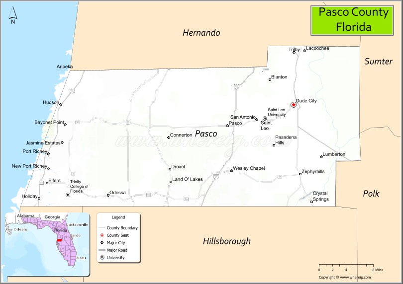
About Pasco County Map, Florida: The map showing the county boundary, county seat, major cities, highways, water bodies and neighbouring counties.
Most Viewed Links
About Pasco County, Florida
Pasco County is located in the west-central part of Florida, in the state of the United States. The county was established in 1887 and was named after Samuel Pasco, a U.S. Senator from Florida. The county seat is Dade City, and the largest city is Wesley Chapel. Pasco County is part of the Tampa Bay metropolitan area and is known for its growing suburban communities, coastal areas, and natural preserves.
Population
According to the United States Census Bureau, the population of Pasco County is 561,891 as recorded in the 2020 Census, and the population density is approximately 756 people per square mile.
Area and Geography
According to the United States Census Bureau, Pasco County covers a total area of approximately 868 square miles (about 2,248 square kilometers), including about 747 square miles (1,935 square kilometers) of land and 121 square miles (313 square kilometers) of water. The county features Gulf Coast shoreline, rivers, wetlands, and expanding residential developments.
Bordering Counties
Pasco County shares boundaries with Hernando County to the north, Sumter County to the northeast, Polk County to the east, and Hillsborough County to the south.
Major Cities and Communities
Major cities and towns include Wesley Chapel, New Port Richey, Port Richey, Dade City, Zephyrhills, and Land O’ Lakes.
Attractions and Recreation
Pasco County offers outdoor recreation including Gulf Coast beaches, parks, and nature preserves. Boating, fishing, and hiking are popular activities throughout the county. Pasco-Hernando State College provides higher education opportunities and supports workforce development in the region.
Transportation
Pasco County is served by Interstate 75, U.S. Highway 19, and the Suncoast Parkway (State Road 589), providing strong regional connectivity within the Tampa Bay area. Major roadways link coastal communities with inland residential and commercial centers.
Explore more counties in Florida Counties or view the complete USA States Map section for additional geographic information.
Sources:
Population and area data sourced from the United States Census Bureau (2020 Census). General county information referenced from the Official Pasco County Government Website.
Facts about Pasco County, Florida
| Country | United States |
| State | Florida |
| Region | West Central Florida (Tampa Bay) |
| County Seat | Dade City |
| Named After | Samuel Pasco |
| Established | 1887 |
| Organized | 1887 |
| Coordinates | 28.3230° N, 82.4572° W |
| Total Area | 868 sq mi |
| Land Area | 747 sq mi |
| Water Area | 121 sq mi |
| Population (2020) | 553,947 |
| Population Rank | One of the fastest-growing counties in Florida |
| Major City | New Port Richey |
| Main Industries | Healthcare, Retail, Logistics, Construction |
| Major Airport | Tampa International Airport (nearby) |
| Time Zone | Eastern Time (UTC−05:00) |
| Known For | Suburban growth, Gulf access, nature preserves |
| Website | https://www.pascocountyfl.net |
Ctities in Pasco county
| City Name | Type | Population (2020) | Pop. Density | Area | Incorporated |
|---|---|---|---|---|---|
| Dade City | City | 7,275 | 3.4 sq mi (8.8 km2) | 1889 | |
| New Port Richey | City | 16,728 | 4.6 sq mi (11.9 km2) | 1924 | |
| Port Richey | City | 3,052 | 2.7 sq mi (7.1 km2) | 1925 | |
| San Antonio | City | 1,297 | 1.2 sq mi (3.2 km2) | 1889 | |
| St. Leo | Town | 2,362 | 1.9 sq mi (4.9 km2) | 1891 | |
| Zephyrhills | City | 17,194 | 6.4 sq mi (16.4 km2) | 1914 |
Top Attractions in Pasco County, Florida
- Weeki Wachee Springs (nearby access) – Mermaid shows and springs.
- Jay B. Starkey Wilderness Park – Hiking, biking, and wildlife.
- Anclote Key Preserve State Park – Beaches and lighthouse.
- Downtown Dade City – Shops and historic charm.
- Werner-Boyce Salt Springs State Park – Coastal trails and kayaking.
- SunWest Park – Recreation lake and beach area.
- Pioneer Florida Museum – State history exhibits.
- Pasco County Courthouse – Historic courthouse landmark.
- St. Leo Abbey – Historic monastery grounds.
- Scenic Coastal & Ridge Drives – Gulf and rolling hill views.
Highways in Pasco
Interstate 75, Alternate 19, U.S. Route 41, U.S. Route 98.
Nearest Airports
Nearest airport of Pasco is Zephyrhills Municipal Airport (ZPH).
- Alachua County Map
- Baker County Map
- Bay County Map
- Bradford County Map
- Brevard County Map
- Broward County Map
- Calhoun County Map
- Charlotte County Map
- Citrus County Map
- Clay County Map
- Collier County Map
- Columbia County Map
- DeSoto County Map
- Dixie County Map
- Duval County Map
- Escambia County Map
- Flagler County Map
- Franklin County Map
- Gadsden County Map
- Gilchrist County Map
- Glades County Map
- Gulf County Map
- Hamilton County Map
- Hardee County Map
- Hendry County Map
- Hernando County Map
- Highlands County Map
- Hillsborough County Map
- Holmes County Map
- Indian River County Map
- Jackson County Map
- Jefferson County Map
- Lafayette County Map
- Lake County Map
- Lee County Map
- Leon County Map
- Levy County Map
- Liberty County Map
- Madison County Map
- Manatee County Map
- Marion County Map
- Martin County Map
- Miami-Dade County Map
- Monroe County Map
- Nassau County Map
- Okaloosa County Map
- Okeechobee County Map
- Orange County Map
- Osceola County Map
- Palm Beach County Map
- Pasco County Map
- Pinellas County Map
- Polk County Map
- Putnam County Map
- St Johns County Map
- St Lucie County Map
- Santa Rosa County Map
- Sarasota County Map
- Seminole County Map
- Sumter County Map
- Suwannee County Map
- Taylor County Map
- Union County Map
- Volusia County Map
- Wakulla County Map
- Walton County Map
- Washington County Map
- Where is Miami
- Where is Hialeah
- Where is Jacksonville
- Where is Orlando
- Where is Saint Petersburg
- Where is Tampa
- Where is Alafaya
- Where is Boca Raton
- Where is Boynton Beach
- Where is Brandon
- Where is Cape Coral
- Where is Clearwater
- Where is Coral Springs
- Where is Davie
- Where is Daytona Beach
- Where is Deerfield Beach
- Where is Deltona
- Where is Doral
- Where is Fort Lauderdale
- Where is Fort Myers
- Where is Gainesville
- Where is Hollywood
- Where is Homestead
- Where is Horizon West
- Where is Kendall
- Where is Kissimmee
- Where is Lakeland
- Where is Largo
- Where is Lauderhill
- Where is Lehigh Acres
- Where is Melbourne
- Where is Miami Beach
- Where is Miami Gardens
- Where is Miramar
- Where is North Port
- Where is Palm Bay
- Where is Palm Coast
- Where is Pembroke Pines
- Where is Plantation
- Where is Poinciana
- Where is Pompano Beach
- Where is Port St. Lucie
- Where is Riverview
- Where is Spring Hill
- Where is St. Petersburg
- Where is Sunrise
- Where is Tallahassee
- Where is Tamarac
- Where is The Villages
- Where is Town 'n' Country
- Where is West Palm Beach