Map of Martin County - Martin County is a county located in the U.S. state of Florida. Martin County Map showing cities, highways, important places and water bodies. Get Where is Martin County located in the map, major cities in Martin county, population, areas, and places of interest.
Map of Martin County, Florida
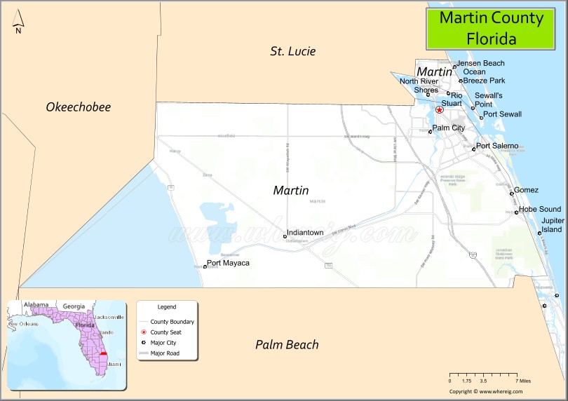
About Martin County Map, Florida: The map showing the county boundary, county seat, major cities, highways, water bodies and neighbouring counties.
Most Viewed Links
About Martin County, Florida
Martin County is located in the southeastern part of Florida, in the state of the United States. The county was established in 1925 and was named after John W. Martin, the 24th Governor of Florida. The county seat and largest city is Stuart. Martin County is part of Florida’s Treasure Coast and is known for its coastal communities, boating culture, and preserved natural areas.
Population
According to the United States Census Bureau, the population of Martin County is 158,431 as recorded in the 2020 Census, and the population density is approximately 284 people per square mile.
Area and Geography
According to the United States Census Bureau, Martin County covers a total area of approximately 753 square miles (about 1,950 square kilometers), including about 543 square miles (1,406 square kilometers) of land and 210 square miles (544 square kilometers) of water. The county features Atlantic Ocean coastline, the Indian River Lagoon, rivers, and inland wetlands.
Bordering Counties
Martin County shares boundaries with St. Lucie County to the north, Okeechobee County to the northwest, Palm Beach County to the south, and the Atlantic Ocean to the east.
Major Cities and Communities
Major cities and towns include Stuart, Jensen Beach, Hobe Sound, Indiantown, and Palm City.
Attractions and Recreation
Martin County offers beaches, boating, fishing, and wildlife observation along the Atlantic coast and Indian River Lagoon. The county features parks, nature preserves, and waterfront communities that support tourism and outdoor recreation. Indian River State College provides higher education access and workforce development opportunities in the region.
Transportation
Martin County is served by Interstate 95 and Florida’s Turnpike, providing north-south connectivity along Florida’s east coast. U.S. Highway 1 runs through coastal communities, supporting regional travel and commerce.
Explore more counties in Florida Counties or view the complete USA States Map section for additional geographic information.
Sources:
Population and area data sourced from the United States Census Bureau (2020 Census). General county information referenced from the Official Martin County Government Website.
Facts about Martin County, Florida
| Country | United States |
| State | Florida |
| Region | Treasure Coast |
| County Seat | Stuart |
| Named After | John W. Martin |
| Established | 1925 |
| Organized | 1925 |
| Coordinates | 27.0836° N, 80.3984° W |
| Total Area | 772 sq mi |
| Land Area | 555 sq mi |
| Water Area | 217 sq mi |
| Population (2020) | 158,431 |
| Population Rank | Mid-sized coastal county on Florida’s east coast |
| Major City | Stuart |
| Main Industries | Tourism, Marine Industries, Healthcare, Agriculture |
| Major Airport | Witham Field (Stuart) |
| Time Zone | Eastern Time (UTC−05:00) |
| Known For | St. Lucie River, boating and fishing, Hutchinson Island beaches |
| Website | https://www.martin.fl.us |
Ctities in Martin county
| City Name | Type | Population (2020) | Pop. Density | Area | Incorporated |
|---|---|---|---|---|---|
| Indiantown | Village | 6,560 | 14.18 sq mi (36.7 km2) | 2017 | |
| Jupiter Island | Town | 804 | 3.6 sq mi (9.3 km2) | 1953 | |
| Ocean Breeze | Town | 301 | 0.2 sq mi (0.5 km2) | 1960 | |
| Sewall's Point | Town | 1,991 | 4.1 sq mi (10.7 km2) | 1957 | |
| Stuart | City | 17,425 | 8.5 sq mi (22.0 km2) | 1914 |
Top Attractions in Martin County, Florida
- Jonathan Dickinson State Park – Hiking, kayaking, and dunes.
- Stuart Downtown Historic District – Shops, dining, and waterfront.
- Blowing Rocks Preserve – Dramatic limestone shoreline.
- Bathtub Reef Beach – Snorkeling and calm waters.
- Elliott Museum – Art, history, and classic cars.
- Florida Oceanographic Coastal Center – Marine life exhibits.
- Hobe Sound National Wildlife Refuge – Sea turtle nesting beach.
- Indian River Lagoon – Kayaking and wildlife viewing.
- St. Lucie Inlet Preserve State Park – Beaches and trails.
- Scenic Coastal Drives – Lagoon and ocean views.
Highways in Martin
U.S. Highway 441, State Road A1A, State Road 76, County Road 707, State Road 710, State Road 714, State Road 732.
Nearest Airports
Nearest airport of Martin is Indiantown Airport.
- Alachua County Map
- Baker County Map
- Bay County Map
- Bradford County Map
- Brevard County Map
- Broward County Map
- Calhoun County Map
- Charlotte County Map
- Citrus County Map
- Clay County Map
- Collier County Map
- Columbia County Map
- DeSoto County Map
- Dixie County Map
- Duval County Map
- Escambia County Map
- Flagler County Map
- Franklin County Map
- Gadsden County Map
- Gilchrist County Map
- Glades County Map
- Gulf County Map
- Hamilton County Map
- Hardee County Map
- Hendry County Map
- Hernando County Map
- Highlands County Map
- Hillsborough County Map
- Holmes County Map
- Indian River County Map
- Jackson County Map
- Jefferson County Map
- Lafayette County Map
- Lake County Map
- Lee County Map
- Leon County Map
- Levy County Map
- Liberty County Map
- Madison County Map
- Manatee County Map
- Marion County Map
- Martin County Map
- Miami-Dade County Map
- Monroe County Map
- Nassau County Map
- Okaloosa County Map
- Okeechobee County Map
- Orange County Map
- Osceola County Map
- Palm Beach County Map
- Pasco County Map
- Pinellas County Map
- Polk County Map
- Putnam County Map
- St Johns County Map
- St Lucie County Map
- Santa Rosa County Map
- Sarasota County Map
- Seminole County Map
- Sumter County Map
- Suwannee County Map
- Taylor County Map
- Union County Map
- Volusia County Map
- Wakulla County Map
- Walton County Map
- Washington County Map
- Where is Miami
- Where is Hialeah
- Where is Jacksonville
- Where is Orlando
- Where is Saint Petersburg
- Where is Tampa
- Where is Alafaya
- Where is Boca Raton
- Where is Boynton Beach
- Where is Brandon
- Where is Cape Coral
- Where is Clearwater
- Where is Coral Springs
- Where is Davie
- Where is Daytona Beach
- Where is Deerfield Beach
- Where is Deltona
- Where is Doral
- Where is Fort Lauderdale
- Where is Fort Myers
- Where is Gainesville
- Where is Hollywood
- Where is Homestead
- Where is Horizon West
- Where is Kendall
- Where is Kissimmee
- Where is Lakeland
- Where is Largo
- Where is Lauderhill
- Where is Lehigh Acres
- Where is Melbourne
- Where is Miami Beach
- Where is Miami Gardens
- Where is Miramar
- Where is North Port
- Where is Palm Bay
- Where is Palm Coast
- Where is Pembroke Pines
- Where is Plantation
- Where is Poinciana
- Where is Pompano Beach
- Where is Port St. Lucie
- Where is Riverview
- Where is Spring Hill
- Where is St. Petersburg
- Where is Sunrise
- Where is Tallahassee
- Where is Tamarac
- Where is The Villages
- Where is Town 'n' Country
- Where is West Palm Beach