Map of Nassau County - Nassau County is a county located in the U.S. state of Florida. Nassau County Map showing cities, highways, important places and water bodies. Get Where is Nassau County located in the map, major cities in Nassau county, population, areas, and places of interest.
Map of Nassau County, Florida
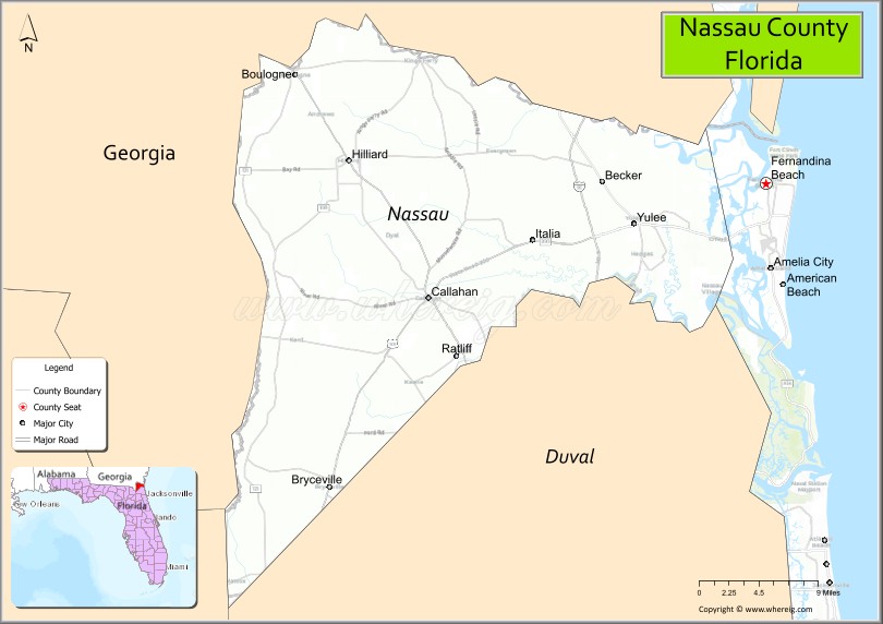
About Nassau County Map, Florida: The map showing the county boundary, county seat, major cities, highways, water bodies and neighbouring counties.
Most Viewed Links
About Nassau County, Florida
Nassau County is located in the northeastern part of Florida, in the state of the United States. The county was established in 1824 and was named after the Duchy of Nassau in Germany. The county seat and largest city is Fernandina Beach. Nassau County is known for its coastal communities, maritime heritage, and proximity to the Jacksonville metropolitan area.
Population
According to the United States Census Bureau, the population of Nassau County is 90,352 as recorded in the 2020 Census, and the population density is approximately 138 people per square mile.
Area and Geography
According to the United States Census Bureau, Nassau County covers a total area of approximately 726 square miles (about 1,880 square kilometers), including about 649 square miles (1,681 square kilometers) of land and 77 square miles (199 square kilometers) of water. The county features Atlantic Ocean coastline, Amelia Island, rivers, marshlands, and inland forests.
Bordering Counties
Nassau County shares boundaries with Georgia to the north, Duval County to the south, and Baker County to the west.
Major Cities and Communities
Major cities and towns include Fernandina Beach, Yulee, Callahan, Hilliard, and Bryceville.
Attractions and Recreation
Nassau County offers beaches and waterfront recreation on Amelia Island, along with parks, boating, and fishing opportunities. The county’s historic downtown Fernandina Beach and maritime heritage contribute to local tourism. Florida State College at Jacksonville serves residents in the broader region and supports higher education access nearby.
Transportation
Nassau County is served by Interstate 95 and State Road A1A, providing north-south coastal connectivity. U.S. Highway 17 runs through inland communities, linking the county to neighboring areas in Northeast Florida and southern Georgia.
Explore more counties in Florida Counties or view the complete USA States Map section for additional geographic information.
Sources:
Population and area data sourced from the United States Census Bureau (2020 Census). General county information referenced from the Official Nassau County Government Website.
Facts about Nassau County, Florida
| Country | United States |
| State | Florida |
| Region | Northeast Florida |
| County Seat | Fernandina Beach |
| Named After | Duchy of Nassau (Germany) |
| Established | 1824 |
| Organized | 1824 |
| Coordinates | 30.6100° N, 81.7700° W |
| Total Area | 726 sq mi |
| Land Area | 649 sq mi |
| Water Area | 77 sq mi |
| Population (2020) | 90,352 |
| Population Rank | Growing county in Northeast Florida |
| Major City | Fernandina Beach |
| Main Industries | Tourism, Manufacturing, Military Support, Logistics |
| Major Airport | Jacksonville International Airport (nearby) |
| Time Zone | Eastern Time (UTC−05:00) |
| Known For | Amelia Island, historic downtown Fernandina Beach, coastal resorts |
| Website | https://www.nassaucountyfl.com |
Ctities in Nassau county
| City Name | Type | Population (2020) | Pop. Density | Area | Incorporated |
|---|---|---|---|---|---|
| Callahan | Town | 1,526 | 1.3 sq mi (3.4 km2) | 1911 | |
| Fernandina Beach | City | 13,052 | 10.7 sq mi (27.8 km2) | 1825 | |
| Hilliard | Town | 2,967 | 5.5 sq mi (14.2 km2) | 1947 |
Top Attractions in Nassau County, Florida
- Amelia Island – Beaches, historic district, and resorts.
- Fort Clinch State Park – Civil War fort and shoreline.
- Downtown Fernandina Beach – Shops, dining, and history.
- Amelia Island Museum of History – Local heritage exhibits.
- Egans Creek Greenway – Trails and wildlife viewing.
- American Beach Museum – African American beach history.
- Fernandina Beach Waterfront – Marina and river views.
- Lofton Creek – Kayaking and scenic paddling.
- Yulee Historic Sites – Early settlement landmarks.
- Scenic Coastal Drives – Marshlands and ocean views.
Highways in Nassau
Interstate 95, Interstate 10, US 1, US 17, US 23, US 90, US 301, SR A1A, SR 2, SR 15A, CR 108, SR 115, CR 119, SR 200.
Nearest Airports
Nearest airport of Nassau is Fernandina Beach Municipal Airport.
- Alachua County Map
- Baker County Map
- Bay County Map
- Bradford County Map
- Brevard County Map
- Broward County Map
- Calhoun County Map
- Charlotte County Map
- Citrus County Map
- Clay County Map
- Collier County Map
- Columbia County Map
- DeSoto County Map
- Dixie County Map
- Duval County Map
- Escambia County Map
- Flagler County Map
- Franklin County Map
- Gadsden County Map
- Gilchrist County Map
- Glades County Map
- Gulf County Map
- Hamilton County Map
- Hardee County Map
- Hendry County Map
- Hernando County Map
- Highlands County Map
- Hillsborough County Map
- Holmes County Map
- Indian River County Map
- Jackson County Map
- Jefferson County Map
- Lafayette County Map
- Lake County Map
- Lee County Map
- Leon County Map
- Levy County Map
- Liberty County Map
- Madison County Map
- Manatee County Map
- Marion County Map
- Martin County Map
- Miami-Dade County Map
- Monroe County Map
- Nassau County Map
- Okaloosa County Map
- Okeechobee County Map
- Orange County Map
- Osceola County Map
- Palm Beach County Map
- Pasco County Map
- Pinellas County Map
- Polk County Map
- Putnam County Map
- St Johns County Map
- St Lucie County Map
- Santa Rosa County Map
- Sarasota County Map
- Seminole County Map
- Sumter County Map
- Suwannee County Map
- Taylor County Map
- Union County Map
- Volusia County Map
- Wakulla County Map
- Walton County Map
- Washington County Map
- Where is Miami
- Where is Hialeah
- Where is Jacksonville
- Where is Orlando
- Where is Saint Petersburg
- Where is Tampa
- Where is Alafaya
- Where is Boca Raton
- Where is Boynton Beach
- Where is Brandon
- Where is Cape Coral
- Where is Clearwater
- Where is Coral Springs
- Where is Davie
- Where is Daytona Beach
- Where is Deerfield Beach
- Where is Deltona
- Where is Doral
- Where is Fort Lauderdale
- Where is Fort Myers
- Where is Gainesville
- Where is Hollywood
- Where is Homestead
- Where is Horizon West
- Where is Kendall
- Where is Kissimmee
- Where is Lakeland
- Where is Largo
- Where is Lauderhill
- Where is Lehigh Acres
- Where is Melbourne
- Where is Miami Beach
- Where is Miami Gardens
- Where is Miramar
- Where is North Port
- Where is Palm Bay
- Where is Palm Coast
- Where is Pembroke Pines
- Where is Plantation
- Where is Poinciana
- Where is Pompano Beach
- Where is Port St. Lucie
- Where is Riverview
- Where is Spring Hill
- Where is St. Petersburg
- Where is Sunrise
- Where is Tallahassee
- Where is Tamarac
- Where is The Villages
- Where is Town 'n' Country
- Where is West Palm Beach