Map of Okaloosa County - Okaloosa County is a county located in the U.S. state of Florida. Okaloosa County Map showing cities, highways, important places and water bodies. Get Where is Okaloosa County located in the map, major cities in Okaloosa county, population, areas, and places of interest.
Map of Okaloosa County, Florida
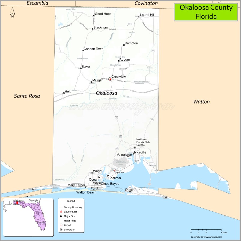
About Okaloosa County Map, Florida: The map showing the county boundary, county seat, major cities, highways, water bodies and neighbouring counties.
Most Viewed Links
About Okaloosa County, Florida
Okaloosa County is located in the northwestern part of Florida, in the state of the United States. The county was established in 1915 and was named after the Choctawhatchee River’s Native American term believed to mean “black water.” The county seat is Crestview, and the largest city is Fort Walton Beach. Okaloosa County is part of the Florida Panhandle and is known for its Gulf Coast beaches, military installations, and tourism industry.
Population
According to the United States Census Bureau, the population of Okaloosa County is 211,668 as recorded in the 2020 Census, and the population density is approximately 226 people per square mile.
Area and Geography
According to the United States Census Bureau, Okaloosa County covers a total area of approximately 1,082 square miles (about 2,802 square kilometers), including about 930 square miles (2,409 square kilometers) of land and 152 square miles (393 square kilometers) of water. The county features Gulf of Mexico coastline, Choctawhatchee Bay, rivers, and inland forests typical of Northwest Florida.
Bordering Counties
Okaloosa County shares boundaries with Alabama to the north, Santa Rosa County to the west, Walton County to the east, and the Gulf of Mexico to the south.
Major Cities and Communities
Major cities and towns include Fort Walton Beach, Crestview, Destin, Niceville, and Mary Esther.
Attractions and Recreation
Okaloosa County offers beaches along the Emerald Coast, boating and fishing on Choctawhatchee Bay, and outdoor recreation in state parks and coastal preserves. The county is also home to Northwest Florida State College, contributing to higher education and workforce development in the region.
Transportation
Okaloosa County is served by Interstate 10 in the northern portion and U.S. Highway 98 along the coast, providing regional connectivity across the Florida Panhandle. Destin–Fort Walton Beach Airport supports domestic air travel.
Explore more counties in Florida Counties or view the complete USA States Map section for additional geographic information.
Sources:
Population and area data sourced from the United States Census Bureau (2020 Census). General county information referenced from the Official Okaloosa County Government Website.
Facts about Okaloosa County, Florida
| Country | United States |
| State | Florida |
| Region | Emerald Coast (Florida Panhandle) |
| County Seat | Crestview |
| Named After | Choctaw word “Okaloosa” meaning “black water” |
| Established | 1915 |
| Organized | 1915 |
| Coordinates | 30.7400° N, 86.5700° W |
| Total Area | 1,082 sq mi |
| Land Area | 936 sq mi |
| Water Area | 146 sq mi |
| Population (2020) | 211,668 |
| Population Rank | One of the more populous counties in the Florida Panhandle |
| Major City | Fort Walton Beach |
| Main Industries | Military, Tourism, Aerospace, Healthcare |
| Major Airport | Destin–Fort Walton Beach Airport |
| Time Zone | Central Time (UTC−06:00) |
| Known For | Emerald Coast beaches, Eglin Air Force Base, tourism |
| Website | https://myokaloosa.com |
Ctities in Okaloosa county
| City Name | Type | Population (2020) | Pop. Density | Area | Incorporated |
|---|---|---|---|---|---|
| Cinco Bayou | Town | 457 | 0.2 sq mi (0.5 km2) | 1950 | |
| Crestview | City | 27,134 | 12.8 sq mi (33.2 km2) | 1916 | |
| Destin | City | 13,931 | 8.2 sq mi (21.2 km2) | 1984 | |
| Fort Walton Beach | City | 20,922 | 8.2 sq mi (21.3 km2) | 1941 | |
| Laurel Hill | City | 584 | 3.1 sq mi (8.1 km2) | 1905 | |
| Mary Esther | City | 3,982 | 1.5 sq mi (4.0 km2) | 1946 | |
| Niceville | City | 15,772 | 11.3 sq mi (29.4 km2) | 1938 | |
| Shalimar | Town | 737 | 0.3 sq mi (0.8 km2) | 1947 | |
| Valparaiso | City | 4,752 | 12.7 sq mi (33.0 km2) | 1921 |
Top Attractions in Okaloosa County, Florida
- Destin Beaches – White sand beaches and emerald waters.
- Henderson Beach State Park – Dunes, trails, and beach access.
- Destin Harbor Boardwalk – Dining, shops, and boat tours.
- Okaloosa Island – Gulf beaches and fishing pier.
- Emerald Coast Science Center – Hands-on science exhibits.
- Air Force Armament Museum – Military aircraft displays.
- Fort Walton Beach Landing Park – Waterfront green space.
- Gulfarium Marine Adventure Park – Marine animal shows.
- Turkey Creek Nature Trail – Boardwalk and creek views.
- Scenic Coastal Drives – Gulf and bay vistas.
Highways in Okaloosa
Interstate 10, US Highway 90, US Highway 98, Florida State Road 4, Florida State Road 85, Florida State Road 188, Florida State Road 189, Florida State Road 293, Florida State Road 393, Florida State Road 397.
Nearest Airports
Nearest airport of Okaloosa is Bob Sikes Airport.
- Alachua County Map
- Baker County Map
- Bay County Map
- Bradford County Map
- Brevard County Map
- Broward County Map
- Calhoun County Map
- Charlotte County Map
- Citrus County Map
- Clay County Map
- Collier County Map
- Columbia County Map
- DeSoto County Map
- Dixie County Map
- Duval County Map
- Escambia County Map
- Flagler County Map
- Franklin County Map
- Gadsden County Map
- Gilchrist County Map
- Glades County Map
- Gulf County Map
- Hamilton County Map
- Hardee County Map
- Hendry County Map
- Hernando County Map
- Highlands County Map
- Hillsborough County Map
- Holmes County Map
- Indian River County Map
- Jackson County Map
- Jefferson County Map
- Lafayette County Map
- Lake County Map
- Lee County Map
- Leon County Map
- Levy County Map
- Liberty County Map
- Madison County Map
- Manatee County Map
- Marion County Map
- Martin County Map
- Miami-Dade County Map
- Monroe County Map
- Nassau County Map
- Okaloosa County Map
- Okeechobee County Map
- Orange County Map
- Osceola County Map
- Palm Beach County Map
- Pasco County Map
- Pinellas County Map
- Polk County Map
- Putnam County Map
- St Johns County Map
- St Lucie County Map
- Santa Rosa County Map
- Sarasota County Map
- Seminole County Map
- Sumter County Map
- Suwannee County Map
- Taylor County Map
- Union County Map
- Volusia County Map
- Wakulla County Map
- Walton County Map
- Washington County Map
- Where is Miami
- Where is Hialeah
- Where is Jacksonville
- Where is Orlando
- Where is Saint Petersburg
- Where is Tampa
- Where is Alafaya
- Where is Boca Raton
- Where is Boynton Beach
- Where is Brandon
- Where is Cape Coral
- Where is Clearwater
- Where is Coral Springs
- Where is Davie
- Where is Daytona Beach
- Where is Deerfield Beach
- Where is Deltona
- Where is Doral
- Where is Fort Lauderdale
- Where is Fort Myers
- Where is Gainesville
- Where is Hollywood
- Where is Homestead
- Where is Horizon West
- Where is Kendall
- Where is Kissimmee
- Where is Lakeland
- Where is Largo
- Where is Lauderhill
- Where is Lehigh Acres
- Where is Melbourne
- Where is Miami Beach
- Where is Miami Gardens
- Where is Miramar
- Where is North Port
- Where is Palm Bay
- Where is Palm Coast
- Where is Pembroke Pines
- Where is Plantation
- Where is Poinciana
- Where is Pompano Beach
- Where is Port St. Lucie
- Where is Riverview
- Where is Spring Hill
- Where is St. Petersburg
- Where is Sunrise
- Where is Tallahassee
- Where is Tamarac
- Where is The Villages
- Where is Town 'n' Country
- Where is West Palm Beach