Map of Duval County - Duval County is a county located in the U.S. state of Florida. Duval County Map showing cities, highways, important places and water bodies. Get Where is Duval County located in the map, major cities in Duval county, population, areas, and places of interest.
Map of Duval County, Florida
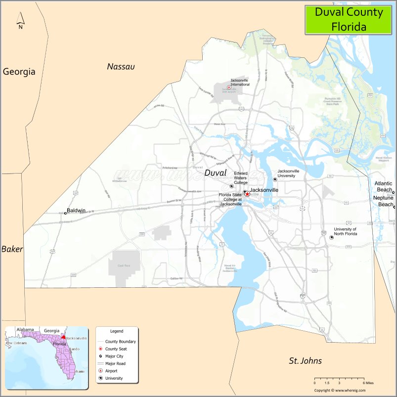
About Duval County Map, Florida: The map showing the county boundary, county seat, major cities, highways, water bodies and neighbouring counties.
Most Viewed Links
About Duval County, Florida
Duval County is located in the northeastern part of Florida, in the state of the United States. The county was established in 1822 and was named after William Pope Duval, the first territorial governor of Florida. The county seat and largest city is Jacksonville. Duval County operates under a consolidated city-county government with Jacksonville, making it one of the most administratively unified counties in Florida.
Population
According to the United States Census Bureau, the population of Duval County was 995,567 as recorded in the 2020 Census.
Area and Geography
According to the United States Census Bureau, Duval County covers a total area of approximately 918 square miles (about 2,377 square kilometers), including about 762 square miles (1,974 square kilometers) of land and 156 square miles (404 square kilometers) of water. The county includes Atlantic coastline, the St. Johns River, and extensive urban development, along with parks and preserved wetlands.
Bordering Counties
Duval County shares boundaries with Nassau County to the north, Clay County to the southwest, St. Johns County to the south, and Georgia to the north across the state line.
Major Cities and Communities
Major cities and towns include Jacksonville, Atlantic Beach, Neptune Beach, and Jacksonville Beach.
Attractions and Recreation
Duval County offers a mix of coastal and urban attractions, including Jacksonville’s riverfront districts, Atlantic Ocean beaches, and numerous parks and preserves. Cultural institutions, professional sports venues, and waterfront recreation along the St. Johns River contribute to the county’s diverse recreational options.
Transportation
Duval County is served by Interstate 95 and Interstate 10, which intersect in Jacksonville and provide regional connectivity. Jacksonville International Airport supports commercial air travel, while major port facilities along the St. Johns River facilitate maritime trade.
Explore more counties in Florida Counties or view the complete USA States Map section for additional geographic information.
Sources:
Population and area data sourced from the United States Census Bureau (2020 Census). General county information referenced from the Official Duval County Government Website.
Facts about Duval County, Florida
| Country | United States |
| State | Florida |
| Region | Northeast Florida |
| County Seat | Jacksonville |
| Named After | William Pope Duval |
| Established | 1822 |
| Organized | 1822 |
| Coordinates | 30.3322° N, 81.6557° W |
| Total Area | 918 sq mi |
| Land Area | 762 sq mi |
| Water Area | 156 sq mi |
| Population (2020) | 995,567 |
| Population Rank | Most populous county in Florida |
| Major City | Jacksonville |
| Main Industries | Logistics, Finance, Healthcare, Military, Port Operations |
| Major Airport | Jacksonville International Airport |
| Time Zone | Eastern Time (UTC−05:00) |
| Known For | Consolidated city-county government, Port of Jacksonville, Atlantic beaches |
| Website | https://www.coj.net |
Ctities in Duval county
| City Name | Type | Population (2020) | Pop. Density | Area | Incorporated |
|---|---|---|---|---|---|
| Atlantic Beach | City | 13,513 | 13.0 sq mi (33.7 km2) | 1926 | |
| Duval | Town | 1,396 | 2.1 sq mi (5.5 km2) | 1876 | |
| Jacksonville | City | 949,611 | 883.6 sq mi (2,292.2 km2) | 1832 | |
| Jacksonville Beach | City | 23,830 | 22.0 sq mi (56.9 km2) | 1907 | |
| Neptune Beach | City | 7,217 | 6.8 sq mi (17.7 km2) | 1931 |
Top Attractions in Duval County, Florida
- Jacksonville Beach – Oceanfront beaches and pier.
- St. Johns Riverwalk – Scenic downtown river views.
- Jacksonville Zoo and Gardens – Wildlife exhibits and gardens.
- Cummer Museum of Art & Gardens – Art collections and riverfront gardens.
- Downtown Jacksonville – Dining, sports, and entertainment.
- Little Talbot Island State Park – Undeveloped beaches and trails.
- Riverside & Avondale Historic Districts – Shops and historic homes.
- TIAA Bank Field – NFL games and major events.
- Friendship Fountain – Iconic city landmark.
- Timucuan Ecological & Historic Preserve – Nature trails and history sites.
Highways in Duval
I-10 / SR 8, I-95 / SR 9, I-295 / SR 9A, US 1 / SR 5, US 1 , US 17, US 23, US 90, US 90 , US 301, SR A1A, SR 9B, SR 10.
Nearest Airports
Nearest airport of Duval are Cecil Airport, Herlong Recreational Airport, Jacksonville Executive at Craig Airport, Jacksonville International Airport.
- Alachua County Map
- Baker County Map
- Bay County Map
- Bradford County Map
- Brevard County Map
- Broward County Map
- Calhoun County Map
- Charlotte County Map
- Citrus County Map
- Clay County Map
- Collier County Map
- Columbia County Map
- DeSoto County Map
- Dixie County Map
- Duval County Map
- Escambia County Map
- Flagler County Map
- Franklin County Map
- Gadsden County Map
- Gilchrist County Map
- Glades County Map
- Gulf County Map
- Hamilton County Map
- Hardee County Map
- Hendry County Map
- Hernando County Map
- Highlands County Map
- Hillsborough County Map
- Holmes County Map
- Indian River County Map
- Jackson County Map
- Jefferson County Map
- Lafayette County Map
- Lake County Map
- Lee County Map
- Leon County Map
- Levy County Map
- Liberty County Map
- Madison County Map
- Manatee County Map
- Marion County Map
- Martin County Map
- Miami-Dade County Map
- Monroe County Map
- Nassau County Map
- Okaloosa County Map
- Okeechobee County Map
- Orange County Map
- Osceola County Map
- Palm Beach County Map
- Pasco County Map
- Pinellas County Map
- Polk County Map
- Putnam County Map
- St Johns County Map
- St Lucie County Map
- Santa Rosa County Map
- Sarasota County Map
- Seminole County Map
- Sumter County Map
- Suwannee County Map
- Taylor County Map
- Union County Map
- Volusia County Map
- Wakulla County Map
- Walton County Map
- Washington County Map
- Where is Miami
- Where is Hialeah
- Where is Jacksonville
- Where is Orlando
- Where is Saint Petersburg
- Where is Tampa
- Where is Alafaya
- Where is Boca Raton
- Where is Boynton Beach
- Where is Brandon
- Where is Cape Coral
- Where is Clearwater
- Where is Coral Springs
- Where is Davie
- Where is Daytona Beach
- Where is Deerfield Beach
- Where is Deltona
- Where is Doral
- Where is Fort Lauderdale
- Where is Fort Myers
- Where is Gainesville
- Where is Hollywood
- Where is Homestead
- Where is Horizon West
- Where is Kendall
- Where is Kissimmee
- Where is Lakeland
- Where is Largo
- Where is Lauderhill
- Where is Lehigh Acres
- Where is Melbourne
- Where is Miami Beach
- Where is Miami Gardens
- Where is Miramar
- Where is North Port
- Where is Palm Bay
- Where is Palm Coast
- Where is Pembroke Pines
- Where is Plantation
- Where is Poinciana
- Where is Pompano Beach
- Where is Port St. Lucie
- Where is Riverview
- Where is Spring Hill
- Where is St. Petersburg
- Where is Sunrise
- Where is Tallahassee
- Where is Tamarac
- Where is The Villages
- Where is Town 'n' Country
- Where is West Palm Beach