Map of Taylor County - Taylor County is a county located in the U.S. state of Florida. Taylor County Map showing cities, highways, important places and water bodies. Get Where is Taylor County located in the map, major cities in Taylor county, population, areas, and places of interest.
Map of Taylor County, Florida
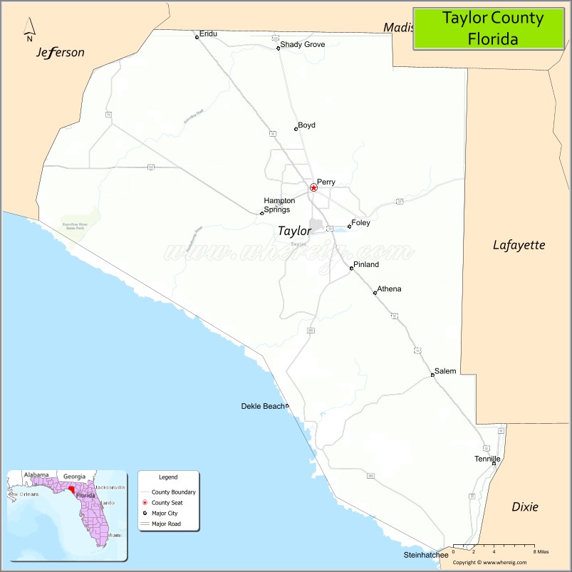
About Taylor County Map, Florida: The map showing the county boundary, county seat, major cities, highways, water bodies and neighbouring counties.
Most Viewed Links
About Taylor County, Florida
Taylor County is located in the northwestern part of Florida, in the state of the United States. The county was established in 1856 and was named after Zachary Taylor, the 12th President of the United States. The county seat and largest city is Perry. Taylor County has a strong forestry and manufacturing base and is known for its Gulf Coast shoreline and rural landscapes.
Population
According to the United States Census Bureau, the population of Taylor County is 21,796 as recorded in the 2020 Census, and the population density is approximately 21 people per square mile.
Area and Geography
According to the United States Census Bureau, Taylor County covers a total area of approximately 1,232 square miles (about 3,191 square kilometers), including about 1,043 square miles (2,702 square kilometers) of land and 189 square miles (489 square kilometers) of water. The county features extensive forested areas, coastal marshlands along the Gulf of Mexico, and rivers that support outdoor recreation and natural habitats.
Bordering Counties
Taylor County shares boundaries with Madison County to the north, Lafayette County to the northeast, Dixie County to the south, and Jefferson County to the east.
Major Cities and Communities
Major cities and towns include Perry, Steinhatchee, Salem, and Shady Grove.
Attractions and Recreation
Taylor County offers outdoor recreation opportunities along the Gulf Coast, particularly in Steinhatchee, which is popular for fishing and boating. The county’s forests and wildlife areas support hunting, camping, and nature exploration. North Florida College provides higher education access for residents in the surrounding region.
Transportation
Taylor County is served by U.S. Highway 19 and U.S. Highway 27, providing north-south connectivity through the Florida Big Bend region. State roads connect coastal and inland communities, supporting local transportation needs.
Explore more counties in Florida Counties or view the complete USA States Map section for additional geographic information.
Sources:
Population and area data sourced from the United States Census Bureau (2020 Census). General county information referenced from the Official Taylor County Government Website.
Facts about Taylor County, Florida
| Country | United States |
| State | Florida |
| Region | North Florida (Big Bend) |
| County Seat | Perry |
| Named After | Zachary Taylor |
| Established | 1856 |
| Organized | 1856 |
| Coordinates | 30.1184° N, 83.5800° W |
| Total Area | 1,043 sq mi |
| Land Area | 1,015 sq mi |
| Water Area | 28 sq mi |
| Population (2020) | 22,190 |
| Population Rank | Small, rural county in North Florida |
| Major City | Perry |
| Main Industries | Forestry, Paper Manufacturing, Agriculture, Fishing |
| Major Airport | Perry–Foley Airport |
| Time Zone | Eastern Time (UTC−05:00) |
| Known For | Forestry industry, Gulf Coast access, rural Big Bend landscapes |
| Website | https://www.taylorcountygov.com |
Ctities in Taylor county
| City Name | Type | Population (2020) | Pop. Density | Area | Incorporated |
|---|---|---|---|---|---|
| Perry | City | 6,898 | 9.3 sq mi (24.1 km2) | 1903 |
Top Attractions in Taylor County, Florida
- Keaton Beach – Fishing village and Gulf sunsets.
- Steinhatchee Falls – Scenic river waterfall.
- Steinhatchee River – Boating, fishing, and kayaking.
- Downtown Perry – Shops and small-town charm.
- Taylor County Courthouse – Historic courthouse landmark.
- Forest Capital Museum State Park – Timber industry history.
- Hampton Springs Park – Spring-fed swimming area.
- Big Bend Wildlife Areas – Birdwatching and nature.
- Scenic Coastal Drives – Marshlands and Gulf views.
- Local Fishing Piers – Fishing and relaxing views.
Highways in Taylor
U.S. Highway 19, U.S. Highway 27, US 27 , U.S. Highway 98, U.S. Highway 221, State Road 51.
Nearest Airports
Nearest airport of Taylor is Perry–Foley Airport.
- Alachua County Map
- Baker County Map
- Bay County Map
- Bradford County Map
- Brevard County Map
- Broward County Map
- Calhoun County Map
- Charlotte County Map
- Citrus County Map
- Clay County Map
- Collier County Map
- Columbia County Map
- DeSoto County Map
- Dixie County Map
- Duval County Map
- Escambia County Map
- Flagler County Map
- Franklin County Map
- Gadsden County Map
- Gilchrist County Map
- Glades County Map
- Gulf County Map
- Hamilton County Map
- Hardee County Map
- Hendry County Map
- Hernando County Map
- Highlands County Map
- Hillsborough County Map
- Holmes County Map
- Indian River County Map
- Jackson County Map
- Jefferson County Map
- Lafayette County Map
- Lake County Map
- Lee County Map
- Leon County Map
- Levy County Map
- Liberty County Map
- Madison County Map
- Manatee County Map
- Marion County Map
- Martin County Map
- Miami-Dade County Map
- Monroe County Map
- Nassau County Map
- Okaloosa County Map
- Okeechobee County Map
- Orange County Map
- Osceola County Map
- Palm Beach County Map
- Pasco County Map
- Pinellas County Map
- Polk County Map
- Putnam County Map
- St Johns County Map
- St Lucie County Map
- Santa Rosa County Map
- Sarasota County Map
- Seminole County Map
- Sumter County Map
- Suwannee County Map
- Taylor County Map
- Union County Map
- Volusia County Map
- Wakulla County Map
- Walton County Map
- Washington County Map
- Where is Miami
- Where is Hialeah
- Where is Jacksonville
- Where is Orlando
- Where is Saint Petersburg
- Where is Tampa
- Where is Alafaya
- Where is Boca Raton
- Where is Boynton Beach
- Where is Brandon
- Where is Cape Coral
- Where is Clearwater
- Where is Coral Springs
- Where is Davie
- Where is Daytona Beach
- Where is Deerfield Beach
- Where is Deltona
- Where is Doral
- Where is Fort Lauderdale
- Where is Fort Myers
- Where is Gainesville
- Where is Hollywood
- Where is Homestead
- Where is Horizon West
- Where is Kendall
- Where is Kissimmee
- Where is Lakeland
- Where is Largo
- Where is Lauderhill
- Where is Lehigh Acres
- Where is Melbourne
- Where is Miami Beach
- Where is Miami Gardens
- Where is Miramar
- Where is North Port
- Where is Palm Bay
- Where is Palm Coast
- Where is Pembroke Pines
- Where is Plantation
- Where is Poinciana
- Where is Pompano Beach
- Where is Port St. Lucie
- Where is Riverview
- Where is Spring Hill
- Where is St. Petersburg
- Where is Sunrise
- Where is Tallahassee
- Where is Tamarac
- Where is The Villages
- Where is Town 'n' Country
- Where is West Palm Beach