Map of Okeechobee County - Okeechobee County is a county located in the U.S. state of Florida. Okeechobee County Map showing cities, highways, important places and water bodies. Get Where is Okeechobee County located in the map, major cities in Okeechobee county, population, areas, and places of interest.
Map of Okeechobee County, Florida
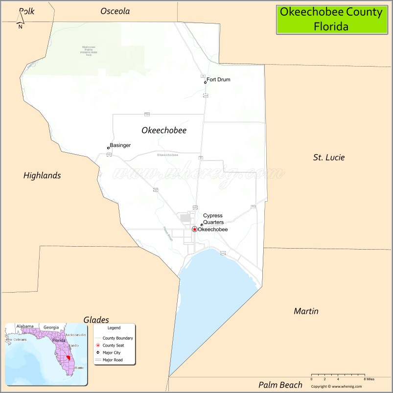
About Okeechobee County Map, Florida: The map showing the county boundary, county seat, major cities, highways, water bodies and neighbouring counties.
Most Viewed Links
About Okeechobee County, Florida
Okeechobee County is located in the south-central part of Florida, in the state of the United States. The county was established in 1917 and was named after Lake Okeechobee, the largest freshwater lake in Florida. The county seat and largest city is Okeechobee. Okeechobee County is known for its agricultural economy, cattle ranching, and access to outdoor recreation around the lake.
Population
According to the United States Census Bureau, the population of Okeechobee County is 39,644 as recorded in the 2020 Census, and the population density is approximately 52 people per square mile.
Area and Geography
According to the United States Census Bureau, Okeechobee County covers a total area of approximately 892 square miles (about 2,310 square kilometers), including about 769 square miles (1,992 square kilometers) of land and 123 square miles (318 square kilometers) of water. The county features shoreline along Lake Okeechobee, flat agricultural lands, wetlands, and rural communities.
Bordering Counties
Okeechobee County shares boundaries with Osceola County to the north, Indian River County to the northeast, St. Lucie County to the east, Martin County to the southeast, Glades County to the south, and Highlands County to the west.
Major Cities and Communities
Major cities and towns include Okeechobee, Taylor Creek, Cypress Quarters, and Buckhead Ridge.
Attractions and Recreation
Okeechobee County offers boating, fishing, and wildlife observation around Lake Okeechobee, making it a popular destination for outdoor enthusiasts. The county’s rural setting and agricultural traditions shape much of its local economy and community life. Indian River State College provides higher education access and workforce training opportunities in the region.
Transportation
Okeechobee County is served by U.S. Highway 441 and State Road 70, providing regional connectivity across South and Central Florida. These routes link the county to coastal and inland communities.
Explore more counties in Florida Counties or view the complete USA States Map section for additional geographic information.
Sources:
Population and area data sourced from the United States Census Bureau (2020 Census). General county information referenced from the Official Okeechobee County Government Website.
Facts about Okeechobee County, Florida
| Country | United States |
| State | Florida |
| Region | South Central Florida |
| County Seat | Okeechobee |
| Named After | Lake Okeechobee |
| Established | 1917 |
| Organized | 1917 |
| Coordinates | 27.3860° N, 80.8890° W |
| Total Area | 769 sq mi |
| Land Area | 769 sq mi |
| Water Area | 0.2 sq mi |
| Population (2020) | 39,644 |
| Population Rank | Small, rural county in South Central Florida |
| Major City | Okeechobee |
| Main Industries | Agriculture, Ranching, Fishing, Food Processing |
| Major Airport | Okeechobee County Airport |
| Time Zone | Eastern Time (UTC−05:00) |
| Known For | Lake Okeechobee fishing, cattle ranches, rural lifestyle |
| Website | https://www.co.okeechobee.fl.us |
Ctities in Okeechobee county
| City Name | Type | Population (2020) | Pop. Density | Area | Incorporated |
|---|---|---|---|---|---|
| Okeechobee | City | 5,254 | 4.2 sq mi (10.8 km2) | 1915 |
Top Attractions in Okeechobee County, Florida
- Lake Okeechobee – Fishing, boating, and lake views.
- Lake Okeechobee Scenic Trail – Walking and biking along the lake.
- Downtown Okeechobee – Shops, dining, and local charm.
- Okeechobee County Courthouse – Historic courthouse landmark.
- Kissimmee Prairie Preserve (nearby access) – Prairie landscapes and stargazing.
- Okeechobee Livestock Market – Local ranching culture.
- Flagler Park – Lakeside park and recreation.
- Okeechobee Battlefield – Second Seminole War history.
- Lake Okeechobee Fishing Piers – Popular angling spots.
- Scenic Rural Drives – Ranchland and wetlands views.
Highways in Okeechobee
US 98, US 441, CR 68, SR 70, SR 78, SR 710.
Nearest Airports
Nearest airport of Okeechobee is Okeechobee County Airport.
- Alachua County Map
- Baker County Map
- Bay County Map
- Bradford County Map
- Brevard County Map
- Broward County Map
- Calhoun County Map
- Charlotte County Map
- Citrus County Map
- Clay County Map
- Collier County Map
- Columbia County Map
- DeSoto County Map
- Dixie County Map
- Duval County Map
- Escambia County Map
- Flagler County Map
- Franklin County Map
- Gadsden County Map
- Gilchrist County Map
- Glades County Map
- Gulf County Map
- Hamilton County Map
- Hardee County Map
- Hendry County Map
- Hernando County Map
- Highlands County Map
- Hillsborough County Map
- Holmes County Map
- Indian River County Map
- Jackson County Map
- Jefferson County Map
- Lafayette County Map
- Lake County Map
- Lee County Map
- Leon County Map
- Levy County Map
- Liberty County Map
- Madison County Map
- Manatee County Map
- Marion County Map
- Martin County Map
- Miami-Dade County Map
- Monroe County Map
- Nassau County Map
- Okaloosa County Map
- Okeechobee County Map
- Orange County Map
- Osceola County Map
- Palm Beach County Map
- Pasco County Map
- Pinellas County Map
- Polk County Map
- Putnam County Map
- St Johns County Map
- St Lucie County Map
- Santa Rosa County Map
- Sarasota County Map
- Seminole County Map
- Sumter County Map
- Suwannee County Map
- Taylor County Map
- Union County Map
- Volusia County Map
- Wakulla County Map
- Walton County Map
- Washington County Map
- Where is Miami
- Where is Hialeah
- Where is Jacksonville
- Where is Orlando
- Where is Saint Petersburg
- Where is Tampa
- Where is Alafaya
- Where is Boca Raton
- Where is Boynton Beach
- Where is Brandon
- Where is Cape Coral
- Where is Clearwater
- Where is Coral Springs
- Where is Davie
- Where is Daytona Beach
- Where is Deerfield Beach
- Where is Deltona
- Where is Doral
- Where is Fort Lauderdale
- Where is Fort Myers
- Where is Gainesville
- Where is Hollywood
- Where is Homestead
- Where is Horizon West
- Where is Kendall
- Where is Kissimmee
- Where is Lakeland
- Where is Largo
- Where is Lauderhill
- Where is Lehigh Acres
- Where is Melbourne
- Where is Miami Beach
- Where is Miami Gardens
- Where is Miramar
- Where is North Port
- Where is Palm Bay
- Where is Palm Coast
- Where is Pembroke Pines
- Where is Plantation
- Where is Poinciana
- Where is Pompano Beach
- Where is Port St. Lucie
- Where is Riverview
- Where is Spring Hill
- Where is St. Petersburg
- Where is Sunrise
- Where is Tallahassee
- Where is Tamarac
- Where is The Villages
- Where is Town 'n' Country
- Where is West Palm Beach