Map of Hernando County - Hernando County is a county located in the U.S. state of Florida. Hernando County Map showing cities, highways, important places and water bodies. Get Where is Hernando County located in the map, major cities in Hernando county, population, areas, and places of interest.
Map of Hernando County, Florida
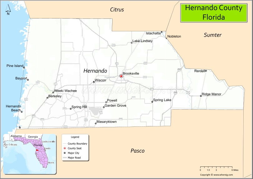
About Hernando County Map, Florida: The map showing the county boundary, county seat, major cities, highways, water bodies and neighbouring counties.
Most Viewed Links
About Hernando County, Florida
Hernando County is located in the west-central part of Florida, in the state of the United States. The county was established in 1843 and was named after Hernando de Soto, the Spanish explorer associated with early expeditions in the southeastern United States. The county seat and largest city is Brooksville. Hernando County is part of the Tampa Bay region and is known for its natural springs, rolling terrain, and expanding residential communities.
Population
According to the United States Census Bureau, the population of Hernando County is 194,515 as recorded in the 2020 Census, and the population density is approximately 409 people per square mile.
Area and Geography
According to the United States Census Bureau, Hernando County covers a total area of approximately 589 square miles (about 1,526 square kilometers), including about 472 square miles (1,223 square kilometers) of land and 117 square miles (303 square kilometers) of water. The county features Gulf Coast shoreline, freshwater springs, rivers, and gently rolling hills that distinguish it from flatter areas of Florida.
Bordering Counties
Hernando County shares boundaries with Citrus County to the north, Sumter County to the east, Pasco County to the south, and the Gulf of Mexico to the west.
Major Cities and Communities
Major cities and towns include Brooksville, Spring Hill, Weeki Wachee, Hernando Beach, and Ridge Manor.
Attractions and Recreation
Hernando County offers outdoor recreation centered around Weeki Wachee Springs State Park and coastal areas along the Gulf of Mexico. Activities include kayaking, fishing, boating, and hiking in preserved natural areas. Pasco-Hernando State College provides higher education opportunities for residents in the region.
Transportation
Hernando County is served by U.S. Highway 19 along the coast and State Road 50, providing east-west connectivity. The Suncoast Parkway (State Road 589) links the county to the Tampa Bay metropolitan area.
Explore more counties in Florida Counties or view the complete USA States Map section for additional geographic information.
Sources:
Population and area data sourced from the United States Census Bureau (2020 Census). General county information referenced from the Official Hernando County Government Website.
Facts about Hernando County, Florida
| Country | United States |
| State | Florida |
| Region | Central West Florida (Nature Coast) |
| County Seat | Brooksville |
| Named After | Hernando de Soto |
| Established | 1843 |
| Organized | 1843 |
| Coordinates | 28.5530° N, 82.4660° W |
| Total Area | 589 sq mi |
| Land Area | 473 sq mi |
| Water Area | 116 sq mi |
| Population (2020) | 194,515 |
| Population Rank | Mid-sized county in West Central Florida |
| Major City | Spring Hill |
| Main Industries | Healthcare, Retail, Construction, Tourism |
| Major Airport | Brooksville–Tampa Bay Regional Airport |
| Time Zone | Eastern Time (UTC−05:00) |
| Known For | Weeki Wachee Springs, mermaid shows, Nature Coast |
| Website | https://www.hernandocounty.us |
Ctities in Hernando county
| City Name | Type | Population (2020) | Pop. Density | Area | Incorporated |
|---|---|---|---|---|---|
| Brooksville | City | 8,890 | 5.0 sq mi (12.9 km2) | 1856 |
Top Attractions in Hernando County, Florida
- Weeki Wachee Springs State Park – Mermaid shows and clear springs.
- Weeki Wachee River – Kayaking and wildlife viewing.
- Chinsegut Hill Historic Site – Historic home and nature trails.
- Downtown Brooksville – Shops and historic charm.
- Hernando Beach – Gulf access and sunsets.
- Withlacoochee State Forest – Hiking, biking, and camping.
- Bayport Park – Fishing pier and coastal views.
- Hernando County Courthouse – Historic courthouse landmark.
- Linda Pedersen Park – Boardwalks and marsh views.
- Scenic Coastal & Ridge Drives – Rolling hills and Gulf scenery.
Highways in Hernando
US 19, US41, US98, US301, SR50.
Nearest Airports
Nearest airport of Hernando is Brooksville–Tampa Bay Regional Airport (ICAO: KBKV, FAA LID: BKV).
- Alachua County Map
- Baker County Map
- Bay County Map
- Bradford County Map
- Brevard County Map
- Broward County Map
- Calhoun County Map
- Charlotte County Map
- Citrus County Map
- Clay County Map
- Collier County Map
- Columbia County Map
- DeSoto County Map
- Dixie County Map
- Duval County Map
- Escambia County Map
- Flagler County Map
- Franklin County Map
- Gadsden County Map
- Gilchrist County Map
- Glades County Map
- Gulf County Map
- Hamilton County Map
- Hardee County Map
- Hendry County Map
- Hernando County Map
- Highlands County Map
- Hillsborough County Map
- Holmes County Map
- Indian River County Map
- Jackson County Map
- Jefferson County Map
- Lafayette County Map
- Lake County Map
- Lee County Map
- Leon County Map
- Levy County Map
- Liberty County Map
- Madison County Map
- Manatee County Map
- Marion County Map
- Martin County Map
- Miami-Dade County Map
- Monroe County Map
- Nassau County Map
- Okaloosa County Map
- Okeechobee County Map
- Orange County Map
- Osceola County Map
- Palm Beach County Map
- Pasco County Map
- Pinellas County Map
- Polk County Map
- Putnam County Map
- St Johns County Map
- St Lucie County Map
- Santa Rosa County Map
- Sarasota County Map
- Seminole County Map
- Sumter County Map
- Suwannee County Map
- Taylor County Map
- Union County Map
- Volusia County Map
- Wakulla County Map
- Walton County Map
- Washington County Map
- Where is Miami
- Where is Hialeah
- Where is Jacksonville
- Where is Orlando
- Where is Saint Petersburg
- Where is Tampa
- Where is Alafaya
- Where is Boca Raton
- Where is Boynton Beach
- Where is Brandon
- Where is Cape Coral
- Where is Clearwater
- Where is Coral Springs
- Where is Davie
- Where is Daytona Beach
- Where is Deerfield Beach
- Where is Deltona
- Where is Doral
- Where is Fort Lauderdale
- Where is Fort Myers
- Where is Gainesville
- Where is Hollywood
- Where is Homestead
- Where is Horizon West
- Where is Kendall
- Where is Kissimmee
- Where is Lakeland
- Where is Largo
- Where is Lauderhill
- Where is Lehigh Acres
- Where is Melbourne
- Where is Miami Beach
- Where is Miami Gardens
- Where is Miramar
- Where is North Port
- Where is Palm Bay
- Where is Palm Coast
- Where is Pembroke Pines
- Where is Plantation
- Where is Poinciana
- Where is Pompano Beach
- Where is Port St. Lucie
- Where is Riverview
- Where is Spring Hill
- Where is St. Petersburg
- Where is Sunrise
- Where is Tallahassee
- Where is Tamarac
- Where is The Villages
- Where is Town 'n' Country
- Where is West Palm Beach