
Where is Fort Myers Located? - Fort Myers is a city located in the Lee County of Florida, United States. Fort Myers lies between 26.64 Degrees North latitudes and 81.87° longitudes.
Location Map of Fort Myers, Florida
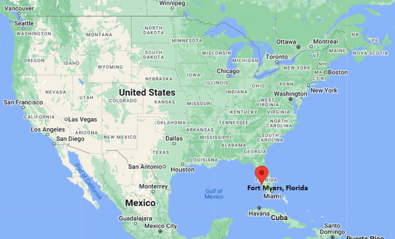
Fort Myers Map, Florida, USA
Where is Fort Myers?: The Google Map showing the location of Fort Myers in the U.S. state of Florida.
Where is Fort Myers Located?
Fort Myers is a city located in Lee County, Florida, United States. Fort Myers is situated at approximately 26.64° North latitude and 81.87° West longitude. According to the 2020 U.S. Census, the population of Fort Myers was 86,395 people, and the city has a land area of 39.84 sq mi. The city has numerous parks and recreational facilities.
Most Viewed US Maps
| USA Sttae Map | USA Region Map | USA Road Map |
| USA County Map | Where is USA in World Map? | US ZIP Code Map |
| USA Time Zones Map | US State and Capitals Map | USA Physical Map |
Find 4,400+ U.S. Cities by State - Explore Their Locations and Get Detailed Information
Fort Myers, Florida Quick Facts
| Property | Information |
|---|---|
| City | Fort Myers |
| County | Lee County |
| State | Florida |
| State Capital | Tallahassee |
| US Region | Southern United States |
| Latitude | 26.6406° N |
| Longitude | 81.8723° W |
| Elevation | 10 ft (3 m) |
| Land Area | 39.04 sq mi |
| Water Area | 9.20 sq mi |
| Total Area | 49.04 sq mi |
| Population (latest Census year) | 86,395 (2020 Census) |
| Population Density | 1,762 per sq mi |
| ZIP Codes | 33901, 33905, 33907, 33908, 33912, 33913, 33916, 33919, 33966, 33967 |
| Area Code | 239 |
| Time Zone Standard | Eastern Standard Time (EST, UTC−5) |
| Time Zone Daylight | Eastern Daylight Time (EDT, UTC−4) |
| Currency | US Dollar (USD) |
| FIPS Code | 12-24125 |
| Congressional District | 19th Congressional District |
Nearby Cities to Fort Myers, Florida
- Cape Coral, Florida — 9 mi West
- North Fort Myers, Florida — 5 mi North
- Fort Myers Beach, Florida — 15 mi Southwest
- Estero, Florida — 16 mi South
- Bonita Springs, Florida — 22 mi South
- Lehigh Acres, Florida — 16 mi East
- Sanibel, Florida — 22 mi Southwest
- Punta Gorda, Florida — 27 mi North
- Naples, Florida — 42 mi South
- Port Charlotte, Florida — 35 mi North
Driving Distances from Fort Myers, Florida
| City | State | Distance (mi) | Approx. Drive Time |
|---|---|---|---|
| North Fort Myers | Florida | 5 | 10 min |
| Cape Coral | Florida | 9 | 15 min |
| Fort Myers Beach | Florida | 15 | 25 min |
| Lehigh Acres | Florida | 16 | 25 min |
| Estero | Florida | 16 | 25 min |
| Bonita Springs | Florida | 22 | 30 min |
| Sanibel | Florida | 22 | 35 min |
| Punta Gorda | Florida | 27 | 35 min |
| Port Charlotte | Florida | 35 | 45 min |
| Naples | Florida | 42 | 50 min |
Transportation and Connectivity in Fort Myers, Florida
| Category | Information |
|---|---|
| Airport Name | Southwest Florida International Airport |
| IATA Code | RSW |
| Port | Port of Fort Myers |
| Major Highways | Interstate 75, U.S. Route 41, State Road 80, State Road 82, State Road 867 |
| Train/Amtrak Service | Nearest Amtrak station is Tampa (connecting bus service available) |
| Local Bus/Transit Service | LeeTran public transit system |
- Interstate 75 provides direct access to Tampa, Naples, Miami, and other major Florida cities.
- U.S. Route 41 (Tamiami Trail) is the principal north-south roadway through Fort Myers and Southwest Florida.
- Southwest Florida International Airport is one of Florida's busiest airports, serving domestic and international destinations.
- LeeTran operates local bus routes throughout Fort Myers, Cape Coral, Bonita Springs, Lehigh Acres, and surrounding communities.
What are top Places to Visit in Fort Myers, Florida
| Landmark Name | Type |
|---|---|
| Edison and Ford Winter Estates | Historic Museum |
| Fort Myers River District | Historic Downtown |
| Six Mile Cypress Slough Preserve | Nature Preserve |
| IMAG History & Science Center | Science Museum |
| Manatee Park | Wildlife Park |
| Lakes Regional Park | City Park |
| Calusa Nature Center & Planetarium | Nature Center |
| Centennial Park | Riverfront Park |
| Fort Myers Beach | Beach |
| Sanibel Island | Island & Nature Destination |
Colleges and Universities in Fort Myers, Florida
| Institution Name | Type | Level | Notable For |
|---|---|---|---|
| Florida SouthWestern State College | Public | State College | Associate and bachelor's degrees, nursing, arts and workforce programs |
| Florida Gulf Coast University | Public | University | Environmental studies, business, engineering and marine science |
| Hodges University | Private | University | Business, technology and professional studies |
| Edison State College (now Florida SouthWestern State College) | Public | State College | Higher education and regional workforce development |
Waterbodies in Fort Myers, Florida
Caloosahatchee River, Gulf of Mexico, Six Mile Cypress Slough, Orange River, Billy's Creek, Ten Mile Canal, Estero Bay, Matlacha Pass
Golf Courses in Fort Myers, Florida
Fort Myers Country Club, Eastwood Golf Course, Pelican Preserve Golf Club, Gateway Golf & Country Club, Legends Golf and Country Club, The Dunes Golf & Tennis Club
Fort Myers, Florida — Key Historical Facts
- Fort Myers was established in 1866 near the former military fort built during the Seminole Wars and named in honor of Colonel Abraham Myers.
- The city gained national recognition as a winter residence for inventors Thomas Edison and Henry Ford, whose estates became major historic attractions.
- During the early twentieth century, Fort Myers developed through agriculture, fishing, tourism, and transportation along the Caloosahatchee River.
- The completion of major highways and regional airport facilities helped transform Fort Myers into a major commercial and tourism center in Southwest Florida.
- Today, Fort Myers is known for its historic River District, waterfront lifestyle, growing economy, baseball spring training facilities, beaches, and access to Gulf Coast attractions.
References
Florida Related Maps and Info
- Where is Miami
- Where is Hialeah
- Where is Jacksonville
- Where is Orlando
- Where is Saint Petersburg
- Where is Tampa
- Where is Alafaya
- Where is Boca Raton
- Where is Boynton Beach
- Where is Brandon
- Where is Cape Coral
- Where is Clearwater
- Where is Coral Springs
- Where is Davie
- Where is Daytona Beach
- Where is Deerfield Beach
- Where is Deltona
- Where is Doral
- Where is Fort Lauderdale
- Where is Fort Myers
- Where is Gainesville
- Where is Hollywood
- Where is Homestead
- Where is Horizon West
- Where is Kendall
- Where is Kissimmee
- Where is Lakeland
- Where is Largo
- Where is Lauderhill
- Where is Lehigh Acres
- Where is Melbourne
- Where is Miami Beach
- Where is Miami Gardens
- Where is Miramar
- Where is North Port
- Where is Palm Bay
- Where is Palm Coast
- Where is Pembroke Pines
- Where is Plantation
- Where is Poinciana
- Where is Pompano Beach
- Where is Port St. Lucie
- Where is Riverview
- Where is Spring Hill
- Where is St. Petersburg
- Where is Sunrise
- Where is Tallahassee
- Where is Tamarac
- Where is The Villages
- Where is Town 'n' Country
- Where is West Palm Beach