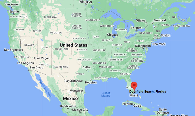
Where is Deerfield Beach Located? - Deerfield Beach is a city located in the Broward County of Florida, United States. Deerfield Beach lies between 21.4823116 Degrees North latitudes and 157.9464013 Degrees West longitudes.
Location Map of Deerfield Beach, Florida
Deerfield Beach Map, Florida, USA
Where is Deerfield Beach?: The Google Map showing the location of Deerfield Beach in the U.S. state of Florida.
Where is Deerfield Beach Located?
Deerfield Beach is a city located in the Broward County of Florida, United States. Deerfield Beach lies between 21.4823116 Degrees North latitudes and 157.9464013 Degrees West longitudes. According to 2020 U.S.census, the population of Deerfield Beach city is 86859 people and the city has a total area of 14.95 sq mi. The city has numerous parks and recreational facilities.
Deerfield Beach, Florida Climate and Weather Overview
Month
Avg High (°F)
Avg Low (°F)
Avg Rainfall (in)
January
76
59
2.7
April
83
68
3.4
July
90
77
6.7
October
86
73
7.1
Annual
84
69
61.9
Climate Attribute
Details
Climate Classification (Köppen)
Tropical Monsoon (Am)
Annual Rainfall
About 62 inches
Annual Sunshine Days
Approximately 246 days
Hurricane/Tornado Risk
High hurricane risk; low tornado risk
Snowfall
None
Driving Distances from Deerfield Beach, Florida
City
State
Distance (mi)
Approx. Drive Time
Boca Raton
Florida
4
10 min
Pompano Beach
Florida
7
15 min
Coconut Creek
Florida
7
15 min
Coral Springs
Florida
12
20 min
Delray Beach
Florida
13
22 min
Fort Lauderdale
Florida
22
30 min
West Palm Beach
Florida
31
40 min
Hollywood
Florida
33
40 min
Miami
Florida
47
55 min
Naples
Florida
118
2 hr
Transportation and Connectivity in Deerfield Beach, Florida
Transportation
Details
Airport Name
Fort Lauderdale-Hollywood International Airport
IATA Code
FLL
Port
Nearby Port Everglades
Major Highways
Interstate 95, Florida's Turnpike, US 1, Hillsboro Boulevard (SR 810), State Road A1A
Train/Amtrak Service
Tri-Rail Deerfield Beach Station; nearest Amtrak station at Deerfield Beach
Local Bus/Transit Service
Broward County Transit (BCT) and Palm Tran connections
Interstate 95 - Primary north-south interstate connecting Deerfield Beach with Miami, Fort Lauderdale, and West Palm Beach.
Florida's Turnpike - Limited-access toll road providing regional travel across central and southern Florida.
US 1 (Federal Highway) - Major commercial corridor serving coastal communities throughout South Florida.
State Road A1A - Scenic coastal highway running alongside the Atlantic Ocean and local beaches.
Hillsboro Boulevard (SR 810) - Main east-west route connecting downtown Deerfield Beach with Interstate 95 and western Broward County.
Key Landmarks and Places to Visit in Deerfield Beach, Florida
Landmark Name
Type
Deerfield Beach International Fishing Pier
Fishing Pier
Quiet Waters Park
Regional Park
Deerfield Island Park
Nature Park
Sullivan Park
Waterfront Park
Constitution Park
City Park
Arboretum at Constitution Park
Botanical Garden
South Inlet Park
Beach Park
Mizner Park
Entertainment District
Hillsboro Inlet Lighthouse
Historic Lighthouse
Butterfly World
Nature Attraction
Colleges and Universities in Deerfield Beach, Florida
Institution Name
Type
Level
Notable For
Broward College - North Campus
Public
Community College
Career and transfer programs
Florida Atlantic University
Public
University
Research and professional education
Lynn University
Private
University
Business and hospitality programs
Palm Beach State College - Boca Raton Campus
Public
Community College
Associate and workforce education
Broward County Public Schools
Public
K-12 District
Public education system
Waterbodies in Deerfield Beach, Florida
Atlantic Ocean, Hillsboro Canal, Intracoastal Waterway, Hillsboro River, Deerfield Island Waterway, Lake Sullivan, Crystal Lake, Hillsboro Inlet
Golf Courses in Deerfield Beach, Florida
Deer Creek Golf Club, Crystal Lake Golf Club, Boca Lago Golf Club, Boca Rio Golf Club, Osprey Point Golf Course, Palm-Aire Country Club
Deerfield Beach, Florida - Key Historical Facts
Deerfield Beach was originally settled in the late 19th century and was named Deerfield because deer frequently grazed along the nearby Hillsboro River.
The community incorporated as the Town of Deerfield in 1925 and later became the City of Deerfield Beach in 1939 to reflect its Atlantic coastline.
The arrival of the Florida East Coast Railway encouraged agricultural development, especially pineapple, tomato, and citrus farming.
During the mid-20th century, the city evolved into a popular coastal destination known for its beaches, fishing pier, and outdoor recreation.
The construction of Interstate 95 and regional highways supported rapid residential and commercial growth throughout South Florida.
Today, Deerfield Beach is recognized for its Blue Wave-certified beach, waterfront parks, marine recreation, and thriving tourism industry.