Map of Lee County - Lee County is a county located in the U.S. state of Florida. Lee County Map showing cities, highways, important places and water bodies. Get Where is Lee County located in the map, major cities in Lee county, population, areas, and places of interest.
Map of Lee County, Florida
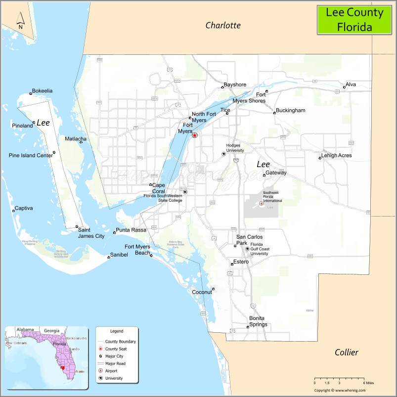
About Lee County Map, Florida: The map showing the county boundary, county seat, major cities, highways, water bodies and neighbouring counties.
Most Viewed Links
About Lee County, Florida
Lee County is located in the southwestern part of Florida, in the state of the United States. The county was established in 1887 and was named after Robert E. Lee, a Confederate general. The county seat and largest city is Fort Myers. Lee County is part of the Cape Coral–Fort Myers metropolitan area and is known for its Gulf Coast beaches, tourism industry, and rapidly growing residential communities.
Population
According to the United States Census Bureau, the population of Lee County is 760,822 as recorded in the 2020 Census, and the population density is approximately 628 people per square mile.
Area and Geography
According to the United States Census Bureau, Lee County covers a total area of approximately 1,212 square miles (about 3,139 square kilometers), including about 785 square miles (2,033 square kilometers) of land and 427 square miles (1,106 square kilometers) of water. The county features Gulf of Mexico coastline, barrier islands such as Sanibel and Captiva, inland waterways, and expanding urban centers.
Bordering Counties
Lee County shares boundaries with Charlotte County to the north, Hendry County to the east, and Collier County to the south.
Major Cities and Communities
Major cities and towns include Fort Myers, Cape Coral, Bonita Springs, Sanibel, and Estero.
Attractions and Recreation
Lee County is widely recognized for its Gulf Coast beaches, island destinations, and waterfront recreation. Activities include boating, fishing, shelling, and wildlife viewing in preserved coastal areas. Florida Gulf Coast University and Florida SouthWestern State College provide higher education opportunities and contribute to research and workforce development in the region.
Transportation
Lee County is served by Interstate 75, U.S. Highway 41, and State Road 82, providing regional connectivity across Southwest Florida. Southwest Florida International Airport supports domestic and international air travel.
Explore more counties in Florida Counties or view the complete USA States Map section for additional geographic information.
Sources:
Population and area data sourced from the United States Census Bureau (2020 Census). General county information referenced from the Official Lee County Government Website.
Facts about Lee County, Florida
| Country | United States |
| State | Florida |
| Region | Southwest Florida |
| County Seat | Fort Myers |
| Named After | Robert E. Lee |
| Established | 1887 |
| Organized | 1887 |
| Coordinates | 26.5533° N, 81.1653° W |
| Total Area | 1,211 sq mi |
| Land Area | 785 sq mi |
| Water Area | 426 sq mi |
| Population (2020) | 760,822 |
| Population Rank | One of the most populous counties in Southwest Florida |
| Major City | Cape Coral |
| Main Industries | Tourism, Healthcare, Real Estate, Construction |
| Major Airport | Southwest Florida International Airport |
| Time Zone | Eastern Time (UTC−05:00) |
| Known For | Gulf Coast beaches, barrier islands, Edison and Ford estates |
| Website | https://www.leegov.com |
Ctities in Lee county
| City Name | Type | Population (2020) | Pop. Density | Area | Incorporated |
|---|---|---|---|---|---|
| Waverly | Town | 159 | 58.5/sq mi (22.6/km2) | 2.72 sq mi (7 km2) | |
| Bonita Springs | City | 53,644 | 41.0 sq mi (106.2 km2) | 1999 | |
| Cape Coral | City | 194,016 | 119.5 sq mi (310.8 km2) | 1970 | |
| Estero | Village | 36,939 | 25.37 sq mi (65.72 km2) | 2015 | |
| Fort Myers | City | 86,395 | 40.4 sq mi (104.7 km2) | 1886 | |
| Fort Myers Beach | Town | 5,582 | 6.2 sq mi (15.9 km2) | 1995 | |
| Sanibel | City | 6,382 | 33.2 sq mi (85.9 km2) | 1974 | |
| Auburn | City | 76,143 | 1,311.2/sq mi (506.3/km2) | 58.07 sq mi (150.4 km2) | |
| Loachapoka | Town | 160 | 140.4/sq mi (54.2/km2) | 1.14 sq mi (3.0) km2) | |
| Opelika | City | 30,995 | 520.1/sq mi (200.8/km2) | 59.59 sq mi (154.3 km2) | |
| Smiths Station | City | 5,384 | 817.0/sq mi (315.4/km2) | 6.59 sq mi (17.1 km2) | |
| Notasulga | Town | 914 | 66.2/sq mi (25.6/km2) | 13.81 sq mi (35.8 km2) | |
| Phenix City | City | 38,816 | 1,398.8/sq mi (540.1/km2) | 27.75 sq mi (71.9 km2) |
- Sanibel Island – Shelling beaches and wildlife.
- Captiva Island – Scenic beaches and sunsets.
- Edison & Ford Winter Estates – Historic homes and gardens.
- Fort Myers Beach – Swimming, dining, and pier.
- Lakes Regional Park – Trails, gardens, and paddle boats.
- J.N. “Ding” Darling National Wildlife Refuge – Birdwatching and kayaking.
- Downtown Fort Myers River District – Shops, dining, and events.
- Six Mile Cypress Slough Preserve – Boardwalks and wetlands.
- Bunche Beach Preserve – Quiet coastal nature area.
- Calusa Nature Center & Planetarium – Nature exhibits and trails.
- Alachua County Map
- Baker County Map
- Bay County Map
- Bradford County Map
- Brevard County Map
- Broward County Map
- Calhoun County Map
- Charlotte County Map
- Citrus County Map
- Clay County Map
- Collier County Map
- Columbia County Map
- DeSoto County Map
- Dixie County Map
- Duval County Map
- Escambia County Map
- Flagler County Map
- Franklin County Map
- Gadsden County Map
- Gilchrist County Map
- Glades County Map
- Gulf County Map
- Hamilton County Map
- Hardee County Map
- Hendry County Map
- Hernando County Map
- Highlands County Map
- Hillsborough County Map
- Holmes County Map
- Indian River County Map
- Jackson County Map
- Jefferson County Map
- Lafayette County Map
- Lake County Map
- Lee County Map
- Leon County Map
- Levy County Map
- Liberty County Map
- Madison County Map
- Manatee County Map
- Marion County Map
- Martin County Map
- Miami-Dade County Map
- Monroe County Map
- Nassau County Map
- Okaloosa County Map
- Okeechobee County Map
- Orange County Map
- Osceola County Map
- Palm Beach County Map
- Pasco County Map
- Pinellas County Map
- Polk County Map
- Putnam County Map
- St Johns County Map
- St Lucie County Map
- Santa Rosa County Map
- Sarasota County Map
- Seminole County Map
- Sumter County Map
- Suwannee County Map
- Taylor County Map
- Union County Map
- Volusia County Map
- Wakulla County Map
- Walton County Map
- Washington County Map
- Where is Miami
- Where is Hialeah
- Where is Jacksonville
- Where is Orlando
- Where is Saint Petersburg
- Where is Tampa
- Where is Alafaya
- Where is Boca Raton
- Where is Boynton Beach
- Where is Brandon
- Where is Cape Coral
- Where is Clearwater
- Where is Coral Springs
- Where is Davie
- Where is Daytona Beach
- Where is Deerfield Beach
- Where is Deltona
- Where is Doral
- Where is Fort Lauderdale
- Where is Fort Myers
- Where is Gainesville
- Where is Hollywood
- Where is Homestead
- Where is Horizon West
- Where is Kendall
- Where is Kissimmee
- Where is Lakeland
- Where is Largo
- Where is Lauderhill
- Where is Lehigh Acres
- Where is Melbourne
- Where is Miami Beach
- Where is Miami Gardens
- Where is Miramar
- Where is North Port
- Where is Palm Bay
- Where is Palm Coast
- Where is Pembroke Pines
- Where is Plantation
- Where is Poinciana
- Where is Pompano Beach
- Where is Port St. Lucie
- Where is Riverview
- Where is Spring Hill
- Where is St. Petersburg
- Where is Sunrise
- Where is Tallahassee
- Where is Tamarac
- Where is The Villages
- Where is Town 'n' Country
- Where is West Palm Beach