Map of Levy County - Levy County is a county located in the U.S. state of Florida. Levy County Map showing cities, highways, important places and water bodies. Get Where is Levy County located in the map, major cities in Levy county, population, areas, and places of interest.
Map of Levy County, Florida
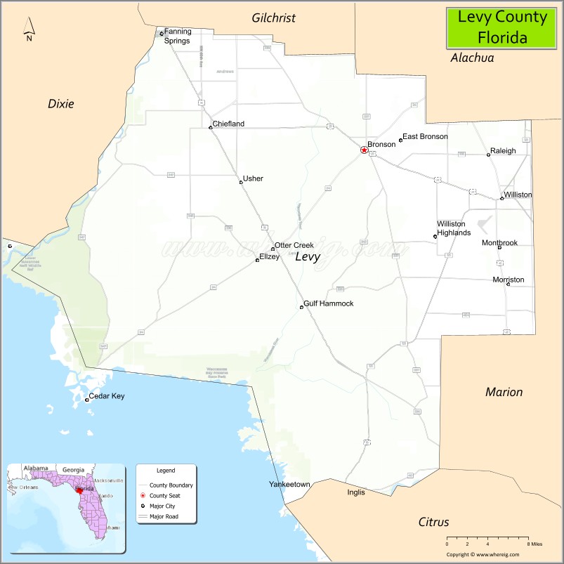
About Levy County Map, Florida: The map showing the county boundary, county seat, major cities, highways, water bodies and neighbouring counties.
Most Viewed Links
About Levy County, Florida
Levy County is located in the north-central part of Florida, in the state of the United States. The county was established in 1845 and was named after David Levy Yulee, one of Florida’s early U.S. Senators. The county seat is Bronson, and the largest city is Williston. Levy County is known for its Gulf Coast shoreline, natural springs, and agricultural economy.
Population
According to the United States Census Bureau, the population of Levy County is 44,276 as recorded in the 2020 Census, and the population density is approximately 39 people per square mile.
Area and Geography
According to the United States Census Bureau, Levy County covers a total area of approximately 1,118 square miles (about 2,895 square kilometers), including about 1,028 square miles (2,663 square kilometers) of land and 90 square miles (233 square kilometers) of water. The county features Gulf of Mexico coastline, rivers such as the Suwannee and Withlacoochee, forests, and rural farmland.
Bordering Counties
Levy County shares boundaries with Dixie County to the north, Gilchrist County to the northeast, Alachua County to the east, Marion County to the southeast, Citrus County to the south, and the Gulf of Mexico to the west.
Major Cities and Communities
Major cities and towns include Williston, Bronson, Chiefland, Cedar Key, and Inglis.
Attractions and Recreation
Levy County offers outdoor recreation opportunities including boating and fishing along the Gulf Coast, particularly in Cedar Key. Natural springs, wildlife refuges, and forested areas support camping, hiking, and birdwatching. The county’s rural character and agricultural activities remain central to its identity.
Transportation
Levy County is served by U.S. Highway 19 and U.S. Highway 27, providing north-south connectivity along Florida’s Gulf Coast. State roads link inland communities with coastal areas and neighboring counties.
Explore more counties in Florida Counties or view the complete USA States Map section for additional geographic information.
Sources:
Population and area data sourced from the United States Census Bureau (2020 Census). General county information referenced from the Official Levy County Government Website.
Facts about Levy County, Florida
| Country | United States |
| State | Florida |
| Region | North Central Florida (Nature Coast) |
| County Seat | Bronson |
| Named After | David Levy Yulee |
| Established | 1845 |
| Organized | 1845 |
| Coordinates | 29.3177° N, 82.7603° W |
| Total Area | 1,184 sq mi |
| Land Area | 1,118 sq mi |
| Water Area | 66 sq mi |
| Population (2020) | 42,915 |
| Population Rank | Mid-sized rural county in North Central Florida |
| Major City | Chiefland |
| Main Industries | Agriculture, Forestry, Mining, Public Services |
| Major Airport | Williston Municipal Airport |
| Time Zone | Eastern Time (UTC−05:00) |
| Known For | Manatee Springs, Gulf Hammock Wildlife Management Area |
| Website | https://www.levycounty.org |
Ctities in Levy county
| City Name | Type | Population (2020) | Pop. Density | Area | Incorporated |
|---|---|---|---|---|---|
| Bronson | Town | 1,140 | 4.0 sq mi (10.4 km2) | 1951 | |
| Cedar Key | City | 687 | 2.0 sq mi (5.3 km2) | 1923 | |
| Chiefland | City | 2,316 | 3.9 sq mi (10.1 km2) | 1913 | |
| Inglis | Town | 1,476 | 3.7 sq mi (9.5 km2) | 1956 | |
| Otter Creek | Town | 108 | 1.5 sq mi (3.8 km2) | 1969 | |
| Williston | City | 2,976 | 6.1 sq mi (15.7 km2) | 1929 | |
| Yankeetown | Town | 588 | 20.3 sq mi (52.6 km2) | 1925 | |
| Fanning Springs | City | 1,182 | 3.7 sq mi (9.6 km2) | 1965 |
Top Attractions in Levy County, Florida
- Cedar Key – Historic island town and fishing.
- Manatee Springs State Park – Spring swimming and trails.
- Lower Suwannee National Wildlife Refuge – Coastal wildlife habitats.
- Downtown Bronson – Small-town shops and charm.
- Levy County Courthouse – Historic courthouse landmark.
- Shell Mound – Prehistoric shell midden site.
- Withlacoochee River Access – Fishing and kayaking.
- Goethe State Forest – Hiking and wildlife viewing.
- Fanning Springs State Park (nearby) – Swimming and springs.
- Scenic Coastal Drives – Marshlands and Gulf views.
Highways in Levy
U.S. Route 19/U.S. Route 98 , U.S. Route 27, Alternate 27 , U.S. Route 41, U.S. Route 129, State Road 24, State Road 121 .
Nearest Airports
Nearest airport of Levy are George T. Lewis Airport, Williston Municipal Airport.
- Alachua County Map
- Baker County Map
- Bay County Map
- Bradford County Map
- Brevard County Map
- Broward County Map
- Calhoun County Map
- Charlotte County Map
- Citrus County Map
- Clay County Map
- Collier County Map
- Columbia County Map
- DeSoto County Map
- Dixie County Map
- Duval County Map
- Escambia County Map
- Flagler County Map
- Franklin County Map
- Gadsden County Map
- Gilchrist County Map
- Glades County Map
- Gulf County Map
- Hamilton County Map
- Hardee County Map
- Hendry County Map
- Hernando County Map
- Highlands County Map
- Hillsborough County Map
- Holmes County Map
- Indian River County Map
- Jackson County Map
- Jefferson County Map
- Lafayette County Map
- Lake County Map
- Lee County Map
- Leon County Map
- Levy County Map
- Liberty County Map
- Madison County Map
- Manatee County Map
- Marion County Map
- Martin County Map
- Miami-Dade County Map
- Monroe County Map
- Nassau County Map
- Okaloosa County Map
- Okeechobee County Map
- Orange County Map
- Osceola County Map
- Palm Beach County Map
- Pasco County Map
- Pinellas County Map
- Polk County Map
- Putnam County Map
- St Johns County Map
- St Lucie County Map
- Santa Rosa County Map
- Sarasota County Map
- Seminole County Map
- Sumter County Map
- Suwannee County Map
- Taylor County Map
- Union County Map
- Volusia County Map
- Wakulla County Map
- Walton County Map
- Washington County Map
- Where is Miami
- Where is Hialeah
- Where is Jacksonville
- Where is Orlando
- Where is Saint Petersburg
- Where is Tampa
- Where is Alafaya
- Where is Boca Raton
- Where is Boynton Beach
- Where is Brandon
- Where is Cape Coral
- Where is Clearwater
- Where is Coral Springs
- Where is Davie
- Where is Daytona Beach
- Where is Deerfield Beach
- Where is Deltona
- Where is Doral
- Where is Fort Lauderdale
- Where is Fort Myers
- Where is Gainesville
- Where is Hollywood
- Where is Homestead
- Where is Horizon West
- Where is Kendall
- Where is Kissimmee
- Where is Lakeland
- Where is Largo
- Where is Lauderhill
- Where is Lehigh Acres
- Where is Melbourne
- Where is Miami Beach
- Where is Miami Gardens
- Where is Miramar
- Where is North Port
- Where is Palm Bay
- Where is Palm Coast
- Where is Pembroke Pines
- Where is Plantation
- Where is Poinciana
- Where is Pompano Beach
- Where is Port St. Lucie
- Where is Riverview
- Where is Spring Hill
- Where is St. Petersburg
- Where is Sunrise
- Where is Tallahassee
- Where is Tamarac
- Where is The Villages
- Where is Town 'n' Country
- Where is West Palm Beach