Map of Madison County - Madison County is a county located in the U.S. state of Florida. It's county seat is Madison. Madison County Map showing cities, highways, important places and water bodies.
Map of Madison County, Florida
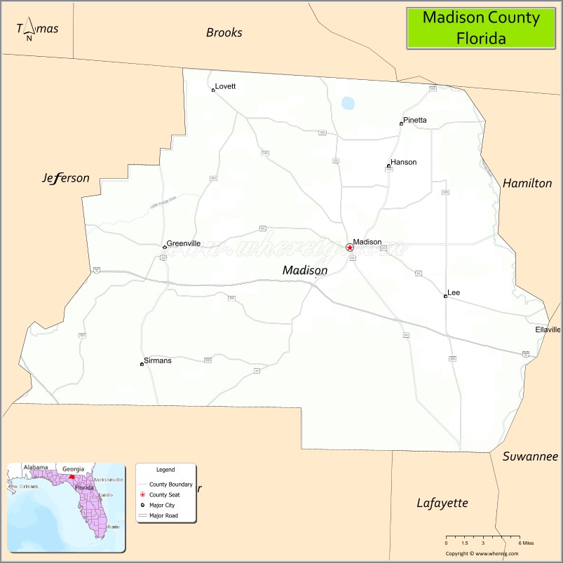
About Madison County Map, Florida: The map showing the county boundary, county seat, major cities, highways, water bodies and neighbouring counties.
Most Viewed Links
About Madison County, Florida
Madison County is located in the north-central part of Florida, in the state of the United States. The county was established in 1827 and was named after James Madison, the fourth President of the United States. The county seat and largest city is Madison. Madison County is primarily rural and is known for its agricultural production, forested landscapes, and small-town communities.
Population
According to the United States Census Bureau, the population of Madison County is 18,649 as recorded in the 2020 Census, and the population density is approximately 27 people per square mile.
Area and Geography
According to the United States Census Bureau, Madison County covers a total area of approximately 716 square miles (about 1,854 square kilometers), including about 696 square miles (1,803 square kilometers) of land and 20 square miles (52 square kilometers) of water. The county features farmland, pine forests, rivers, and rolling terrain typical of inland North Florida.
Bordering Counties
Madison County shares boundaries with Georgia to the north, Hamilton County to the east, Suwannee County to the southeast, Lafayette County to the south, Taylor County to the southwest, and Jefferson County to the west.
Major Cities and Communities
Major cities and towns include Madison, Greenville, Lee, and Pinetta.
Attractions and Recreation
Madison County offers outdoor recreation opportunities including fishing, boating, and camping along local rivers and forested areas. The county’s agricultural heritage and historic downtown Madison reflect its rural character.
Transportation
Madison County is served by Interstate 10, which runs east-west across the county, and U.S. Highway 90, providing regional connectivity within North Florida. These routes connect the county to neighboring communities and states.
Explore more counties in Florida Counties or view the complete USA States Map section for additional geographic information.
Sources:
Population and area data sourced from the United States Census Bureau (2020 Census). General county information referenced from the Official Madison County Government Website.
Facts about Madison County, Florida
| Country | United States |
| State | Florida |
| Region | North Florida |
| County Seat | Madison |
| Named After | James Madison |
| Established | 1827 |
| Organized | 1827 |
| Coordinates | 30.4704° N, 83.4126° W |
| Total Area | 695 sq mi |
| Land Area | 692 sq mi |
| Water Area | 3 sq mi |
| Population (2020) | 18,903 |
| Population Rank | Small, rural county in North Florida |
| Major City | Madison |
| Main Industries | Agriculture, Forestry, Manufacturing, Public Services |
| Major Airport | Madison County Airport |
| Time Zone | Eastern Time (UTC−05:00) |
| Known For | Suwannee River, rural landscapes, historic downtown Madison |
| Website | https://www.madisonfl.org |
Ctities in Madison county
| City Name | Type | Population (2020) | Pop. Density | Area | Incorporated |
|---|---|---|---|---|---|
| Greenville | Town | 746 | 1.3 sq mi (3.4 km2) | 1907 | |
| Lee | Town | 375 | 1.2 sq mi (3.2 km2) | 1909 | |
| Madison | City | 2,912 | 2.5 sq mi (6.7 km2) | 1945 | |
| Gurley | Town | 816 | 231.8/sq mi (89.5/km2) | 3.52 sq mi (9.1 km2) | |
| New Hope | City | 2,889 | 333.6/sq mi (128.8/km2) | 8.66 sq mi (22.4 km2) | |
| Owens Cross Roads | City | 2,594 | 312.5/sq mi (120.7/km2) | 8.3 sq mi (21.5 km2) | |
| Triana | Town | 2,890 | 2,312.0/sq mi (892.7/km2) | 1.25 sq mi (3.2 km2) | |
| Madison | City | 56,933 | 1,924.1/sq mi (742.9/km2) | 29.59 sq mi (76.6 km2) | |
| Huntsville | City | 215,006 | 1,028.5/sq mi (397.1/km2) | 209.05 sq mi (541.4 km2) |
Top Attractions in Madison County, Florida
- Madison Blue Spring State Park – Clear spring swimming.
- Suwannee River – Canoeing, fishing, and scenic views.
- Downtown Madison – Historic shops and charm.
- Madison County Courthouse – Historic courthouse landmark.
- Yogi Bear’s Jellystone Park – Family camping and activities.
- Cherry Lake – Fishing and outdoor recreation.
- Four Freedoms Trail – Walking trail and memorials.
- North Florida College Area – Cultural and community events.
- Rural Farmland Drives – Scenic countryside views.
- Local Nature Trails – Walking and wildlife viewing.
Highways in Madison
Interstate 10, US 19/27, US 90, US 221, State Road 6, State Road 14, State Road 53, State Road 145.
Nearest Airports
Nearest airport of Madison is Valdosta Regional Airport (VLD / KVLD).
- Alachua County Map
- Baker County Map
- Bay County Map
- Bradford County Map
- Brevard County Map
- Broward County Map
- Calhoun County Map
- Charlotte County Map
- Citrus County Map
- Clay County Map
- Collier County Map
- Columbia County Map
- DeSoto County Map
- Dixie County Map
- Duval County Map
- Escambia County Map
- Flagler County Map
- Franklin County Map
- Gadsden County Map
- Gilchrist County Map
- Glades County Map
- Gulf County Map
- Hamilton County Map
- Hardee County Map
- Hendry County Map
- Hernando County Map
- Highlands County Map
- Hillsborough County Map
- Holmes County Map
- Indian River County Map
- Jackson County Map
- Jefferson County Map
- Lafayette County Map
- Lake County Map
- Lee County Map
- Leon County Map
- Levy County Map
- Liberty County Map
- Madison County Map
- Manatee County Map
- Marion County Map
- Martin County Map
- Miami-Dade County Map
- Monroe County Map
- Nassau County Map
- Okaloosa County Map
- Okeechobee County Map
- Orange County Map
- Osceola County Map
- Palm Beach County Map
- Pasco County Map
- Pinellas County Map
- Polk County Map
- Putnam County Map
- St Johns County Map
- St Lucie County Map
- Santa Rosa County Map
- Sarasota County Map
- Seminole County Map
- Sumter County Map
- Suwannee County Map
- Taylor County Map
- Union County Map
- Volusia County Map
- Wakulla County Map
- Walton County Map
- Washington County Map
- Where is Miami
- Where is Hialeah
- Where is Jacksonville
- Where is Orlando
- Where is Saint Petersburg
- Where is Tampa
- Where is Alafaya
- Where is Boca Raton
- Where is Boynton Beach
- Where is Brandon
- Where is Cape Coral
- Where is Clearwater
- Where is Coral Springs
- Where is Davie
- Where is Daytona Beach
- Where is Deerfield Beach
- Where is Deltona
- Where is Doral
- Where is Fort Lauderdale
- Where is Fort Myers
- Where is Gainesville
- Where is Hollywood
- Where is Homestead
- Where is Horizon West
- Where is Kendall
- Where is Kissimmee
- Where is Lakeland
- Where is Largo
- Where is Lauderhill
- Where is Lehigh Acres
- Where is Melbourne
- Where is Miami Beach
- Where is Miami Gardens
- Where is Miramar
- Where is North Port
- Where is Palm Bay
- Where is Palm Coast
- Where is Pembroke Pines
- Where is Plantation
- Where is Poinciana
- Where is Pompano Beach
- Where is Port St. Lucie
- Where is Riverview
- Where is Spring Hill
- Where is St. Petersburg
- Where is Sunrise
- Where is Tallahassee
- Where is Tamarac
- Where is The Villages
- Where is Town 'n' Country
- Where is West Palm Beach