Map of Charlotte County - Charlotte County is a county located in the U.S. state of Florida. Charlotte County Map showing cities, highways, important places and water bodies. Get Where is Charlotte County located in the map, major cities in Charlotte county, population, areas, and places of interest.
Map of Charlotte County, Florida
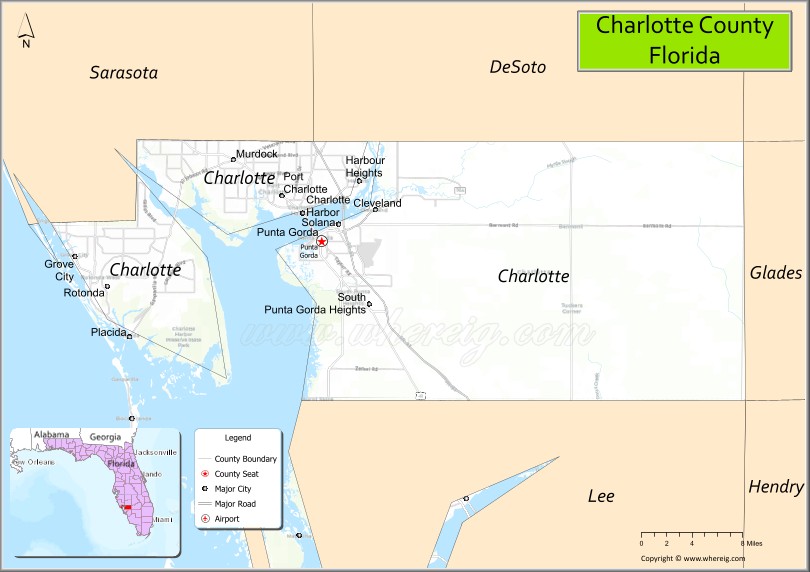
About Charlotte County Map, Florida: The map showing the county boundary, county seat, major cities, highways, water bodies and neighbouring counties.
Most Viewed Links
About Charlotte County, Florida
Charlotte County is located along the southwestern coast of Florida, United States. The county was established in 1921 and was named after Charlotte Harbor. The county seat is Punta Gorda, which also serves as the largest city and a major center for tourism and waterfront living. Charlotte County is known for its coastal communities, boating culture, and scenic Gulf Coast landscapes.
Population
According to the United States Census Bureau, the population of Charlotte County was 186,847 as recorded in the 2020 Census. The population is concentrated in Punta Gorda and surrounding coastal and suburban communities.
Area and Geography
According to the United States Census Bureau, Charlotte County covers a total area of approximately 858 square miles (about 2,222 square kilometers), including about 680 square miles (1,761 square kilometers) of land and 178 square miles (461 square kilometers) of water. The county features extensive shoreline along Charlotte Harbor and the Gulf of Mexico, with numerous waterways, barrier islands, and coastal wetlands.
Bordering Counties
Charlotte County shares borders with DeSoto County to the north, Hardee County to the northeast, Glades County to the east, Lee County to the south, and Sarasota County to the northwest.
Major Cities and Communities
The principal communities in Charlotte County include Punta Gorda, Port Charlotte, Englewood, and Rotonda West, which serve as residential, commercial, and tourism centers.
Attractions and Recreation
Charlotte County offers a wide range of outdoor recreation including boating, fishing, kayaking, and beach activities along the Gulf Coast. Parks, nature preserves, and waterfront trails provide opportunities for wildlife viewing and year-round outdoor enjoyment.
Transportation
Major transportation routes serving Charlotte County include Interstate 75 and U.S. Highway 41, providing north-south connectivity along Florida’s Gulf Coast and access to neighboring counties.
Explore more counties in Florida Counties or view the complete USA States Map section for additional geographic information.
Sources:
Population and area data sourced from the United States Census Bureau (2020 Census). General county information referenced from the Official Charlotte County Government Website.
Facts about Charlotte County, Florida
| Country | United States |
| State | Florida |
| Region | Southwest Florida |
| County Seat | Punta Gorda |
| Named After | Charlotte Harbor |
| Established | 1921 |
| Organized | 1921 |
| Coordinates | 26.9298° N, 81.9500° W |
| Total Area | 858 sq mi |
| Land Area | 680 sq mi |
| Water Area | 178 sq mi |
| Population (2020) | 186,847 |
| Population Rank | Mid-sized county in Southwest Florida |
| Major City | Port Charlotte |
| Main Industries | Tourism, Healthcare, Real Estate, Marine Trades |
| Major Airport | Punta Gorda Airport |
| Time Zone | Eastern Time (UTC−05:00) |
| Known For | Charlotte Harbor, boating and fishing, Gulf Coast lifestyle |
| Website | https://www.charlottecountyfl.gov |
Ctities in Charlotte county
| City Name | Type | Population (2020) | Pop. Density | Area | Incorporated |
|---|---|---|---|---|---|
| Punta Gorda | City | 19,471 | 18.5 sq mi (47.9 km2) | 1900 |
Top Attractions in Charlotte County, Florida
- Fishermen’s Village – Waterfront shops, dining, and marina.
- Port Charlotte Beach Park – Swimming, fishing, and sunsets.
- Peace River Wildlife Center – Native wildlife rehabilitation.
- Charlotte Harbor Preserve State Park – Trails and coastal habitats.
- Englewood Beach – Gulf beach and shelling.
- Tippecanoe Environmental Park – Boardwalks and nature trails.
- Downtown Punta Gorda – Historic district and riverwalk.
- Harborwalk – Scenic waterfront walking path.
- Alligator Creek Preserve – Hiking and wildlife viewing.
- Charlotte Sports Park – Spring training and events.
Highways in Charlotte
CR 74, CR 762, CR 764, CR 765, CR 765 , CR 765A.
Nearest Airports
Nearest airport of Charlotte is Punta Gorda Airport (Florida).
- Alachua County Map
- Baker County Map
- Bay County Map
- Bradford County Map
- Brevard County Map
- Broward County Map
- Calhoun County Map
- Charlotte County Map
- Citrus County Map
- Clay County Map
- Collier County Map
- Columbia County Map
- DeSoto County Map
- Dixie County Map
- Duval County Map
- Escambia County Map
- Flagler County Map
- Franklin County Map
- Gadsden County Map
- Gilchrist County Map
- Glades County Map
- Gulf County Map
- Hamilton County Map
- Hardee County Map
- Hendry County Map
- Hernando County Map
- Highlands County Map
- Hillsborough County Map
- Holmes County Map
- Indian River County Map
- Jackson County Map
- Jefferson County Map
- Lafayette County Map
- Lake County Map
- Lee County Map
- Leon County Map
- Levy County Map
- Liberty County Map
- Madison County Map
- Manatee County Map
- Marion County Map
- Martin County Map
- Miami-Dade County Map
- Monroe County Map
- Nassau County Map
- Okaloosa County Map
- Okeechobee County Map
- Orange County Map
- Osceola County Map
- Palm Beach County Map
- Pasco County Map
- Pinellas County Map
- Polk County Map
- Putnam County Map
- St Johns County Map
- St Lucie County Map
- Santa Rosa County Map
- Sarasota County Map
- Seminole County Map
- Sumter County Map
- Suwannee County Map
- Taylor County Map
- Union County Map
- Volusia County Map
- Wakulla County Map
- Walton County Map
- Washington County Map
- Where is Miami
- Where is Hialeah
- Where is Jacksonville
- Where is Orlando
- Where is Saint Petersburg
- Where is Tampa
- Where is Alafaya
- Where is Boca Raton
- Where is Boynton Beach
- Where is Brandon
- Where is Cape Coral
- Where is Clearwater
- Where is Coral Springs
- Where is Davie
- Where is Daytona Beach
- Where is Deerfield Beach
- Where is Deltona
- Where is Doral
- Where is Fort Lauderdale
- Where is Fort Myers
- Where is Gainesville
- Where is Hollywood
- Where is Homestead
- Where is Horizon West
- Where is Kendall
- Where is Kissimmee
- Where is Lakeland
- Where is Largo
- Where is Lauderhill
- Where is Lehigh Acres
- Where is Melbourne
- Where is Miami Beach
- Where is Miami Gardens
- Where is Miramar
- Where is North Port
- Where is Palm Bay
- Where is Palm Coast
- Where is Pembroke Pines
- Where is Plantation
- Where is Poinciana
- Where is Pompano Beach
- Where is Port St. Lucie
- Where is Riverview
- Where is Spring Hill
- Where is St. Petersburg
- Where is Sunrise
- Where is Tallahassee
- Where is Tamarac
- Where is The Villages
- Where is Town 'n' Country
- Where is West Palm Beach