Map of Clay County - Clay County is a county located in the U.S. state of Florida. Clay County Map showing cities, highways, important places and water bodies. Get Where is Clay County located in the map, major cities in Clay county, population, areas, and places of interest.
Map of Clay County, Florida
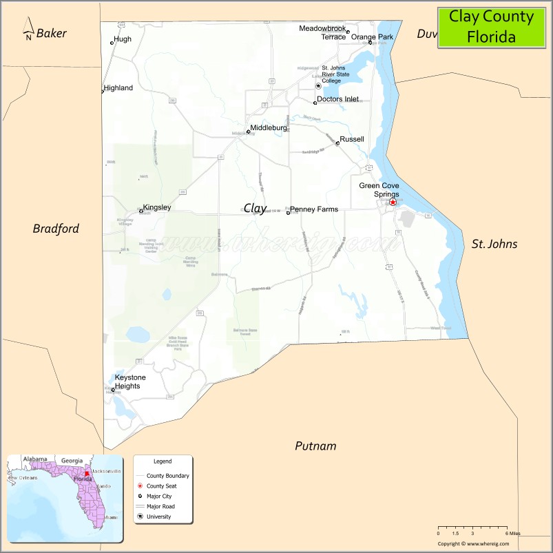
About Clay County Map, Florida: The map showing the county boundary, county seat, major cities, highways, water bodies and neighbouring counties.
Most Viewed Links
About Clay County, Florida
Clay County is located in the northeastern part of Florida, United States. The county was established in 1858 and was named after Henry Clay, an American statesman. The county seat is Green Cove Springs, while Orange Park is one of the largest communities in the county. Clay County is known for its suburban growth, military presence near Jacksonville, and scenic riverfront communities along the St. Johns River.
Population
According to the United States Census Bureau, the population of Clay County was 218,245 as recorded in the 2020 Census. The population is concentrated in suburban communities such as Orange Park and Fleming Island, with continued residential development throughout the county.
Area and Geography
According to the United States Census Bureau, Clay County covers a total area of approximately 644 square miles (about 1,668 square kilometers), including about 604 square miles (1,565 square kilometers) of land and 40 square miles (103 square kilometers) of water. The county features river systems, lakes, and wooded areas that contribute to its natural character.
Bordering Counties
Clay County shares borders with Baker County to the northwest, Duval County to the northeast, St. Johns County to the east, Putnam County to the south, and Bradford County to the west.
Major Cities and Communities
The principal communities in Clay County include Green Cove Springs, Orange Park, Fleming Island, and Keystone Heights, which serve as residential, commercial, and civic centers.
Attractions and Recreation
Clay County offers outdoor recreation including boating, fishing, and waterfront parks along the St. Johns River and local lakes. Community events, historic districts, and nearby state parks contribute to the county’s recreational appeal.
Transportation
Major transportation routes serving Clay County include U.S. Highway 17 and State Road 21, providing connectivity to Jacksonville and other parts of northeastern Florida.
Explore more counties in Florida Counties or view the complete USA States Map section for additional geographic information.
Sources:
Population and area data sourced from the United States Census Bureau (2020 Census). General county information referenced from the Official Clay County Government Website.
Facts about Clay County, Florida
| Country | United States |
| State | Florida |
| Region | Northeast Florida |
| County Seat | Green Cove Springs |
| Named After | Henry Clay |
| Established | 1858 |
| Organized | 1858 |
| Coordinates | 29.9826° N, 81.8591° W |
| Total Area | 644 sq mi |
| Land Area | 604 sq mi |
| Water Area | 40 sq mi |
| Population (2020) | 212,969 |
| Population Rank | Growing suburban county in Northeast Florida |
| Major City | Orange Park |
| Main Industries | Healthcare, Retail, Education, Military Support |
| Major Airport | Cecil Airport (nearby) |
| Time Zone | Eastern Time (UTC−05:00) |
| Known For | St. Johns River, military community, suburban growth |
| Website | https://www.claycountygov.com |
Ctities in Clay county
| City Name | Type | Population (2020) | Pop. Density | Area | Incorporated |
|---|---|---|---|---|---|
| Green Cove Springs | City | 9,786 | 9.4 sq mi (24.5 km2) | 1874 | |
| Orange Park | Town | 9,089 | 5.6 sq mi (14.4 km2) | 1879 | |
| Penney Farms | Town | 821 | 1.4 sq mi (3.6 km2) | 1927 | |
| Ashland | Town | 1,984 | 271.0/sq mi (104.6/km2) | 7.32 sq mi (19 km2) | |
| Lineville | City | 2,489 | 278.4/sq mi (107.5/km2) | 8.94 sq mi (23.2 km2) | |
| Keystone Heights | City | 1,446 | 4.6 sq mi (12.0 km2) | 1925 |
Top Attractions in Clay County, Florida
- Black Creek Ravines Conservation Area – Hiking trails and ravines.
- Gold Head Branch State Park – Springs, trails, and camping.
- Camp Blanding Museum – Military history exhibits.
- Downtown Green Cove Springs – Shops and riverfront charm.
- Spring Park – Natural spring and waterfront park.
- Mike Roess Gold Head Branch State Park – Scenic lakes and forests.
- Doctors Lake – Boating and fishing.
- Keystone Heights Lakes – Swimming and water recreation.
- Camp Chowenwaw Park – Nature trails and historic lodge.
- St. Johns River Access – Scenic river views.
Highways in Clay
US 17, US 301, SR 16, SR 21, SR 23, SR 100.
Nearest Airports
Nearest airport of Clay is Keystone Heights Airport.
- Alachua County Map
- Baker County Map
- Bay County Map
- Bradford County Map
- Brevard County Map
- Broward County Map
- Calhoun County Map
- Charlotte County Map
- Citrus County Map
- Clay County Map
- Collier County Map
- Columbia County Map
- DeSoto County Map
- Dixie County Map
- Duval County Map
- Escambia County Map
- Flagler County Map
- Franklin County Map
- Gadsden County Map
- Gilchrist County Map
- Glades County Map
- Gulf County Map
- Hamilton County Map
- Hardee County Map
- Hendry County Map
- Hernando County Map
- Highlands County Map
- Hillsborough County Map
- Holmes County Map
- Indian River County Map
- Jackson County Map
- Jefferson County Map
- Lafayette County Map
- Lake County Map
- Lee County Map
- Leon County Map
- Levy County Map
- Liberty County Map
- Madison County Map
- Manatee County Map
- Marion County Map
- Martin County Map
- Miami-Dade County Map
- Monroe County Map
- Nassau County Map
- Okaloosa County Map
- Okeechobee County Map
- Orange County Map
- Osceola County Map
- Palm Beach County Map
- Pasco County Map
- Pinellas County Map
- Polk County Map
- Putnam County Map
- St Johns County Map
- St Lucie County Map
- Santa Rosa County Map
- Sarasota County Map
- Seminole County Map
- Sumter County Map
- Suwannee County Map
- Taylor County Map
- Union County Map
- Volusia County Map
- Wakulla County Map
- Walton County Map
- Washington County Map
- Where is Miami
- Where is Hialeah
- Where is Jacksonville
- Where is Orlando
- Where is Saint Petersburg
- Where is Tampa
- Where is Alafaya
- Where is Boca Raton
- Where is Boynton Beach
- Where is Brandon
- Where is Cape Coral
- Where is Clearwater
- Where is Coral Springs
- Where is Davie
- Where is Daytona Beach
- Where is Deerfield Beach
- Where is Deltona
- Where is Doral
- Where is Fort Lauderdale
- Where is Fort Myers
- Where is Gainesville
- Where is Hollywood
- Where is Homestead
- Where is Horizon West
- Where is Kendall
- Where is Kissimmee
- Where is Lakeland
- Where is Largo
- Where is Lauderhill
- Where is Lehigh Acres
- Where is Melbourne
- Where is Miami Beach
- Where is Miami Gardens
- Where is Miramar
- Where is North Port
- Where is Palm Bay
- Where is Palm Coast
- Where is Pembroke Pines
- Where is Plantation
- Where is Poinciana
- Where is Pompano Beach
- Where is Port St. Lucie
- Where is Riverview
- Where is Spring Hill
- Where is St. Petersburg
- Where is Sunrise
- Where is Tallahassee
- Where is Tamarac
- Where is The Villages
- Where is Town 'n' Country
- Where is West Palm Beach