Map of Dixie County - Dixie County is a county located in the U.S. state of Florida. Dixie County Map showing cities, highways, important places and water bodies. Get Where is Dixie County located in the map, major cities in Dixie county, population, areas, and places of interest.
Map of Dixie County, Florida
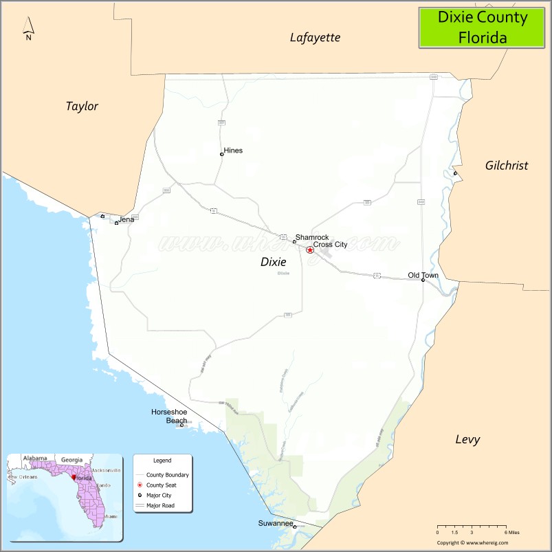
About Dixie County Map, Florida: The map showing the county boundary, county seat, major cities, highways, water bodies and neighbouring counties.
Most Viewed Links
About Dixie County, Florida
Dixie County is located in the northwestern part of Florida, in the state of the United States. The county was established in 1921 and was named to reflect its location in the traditional “Dixie” region of the southern United States. The county seat and largest city is Cross City. Dixie County is largely rural and is known for its natural landscapes, coastal marshes, and small-town character along Florida’s Gulf Coast.
Population
According to the United States Census Bureau, the population of Dixie County was 16,759 as recorded in the 2020 Census.
Area and Geography
According to the United States Census Bureau, Dixie County covers a total area of approximately 864 square miles (about 2,238 square kilometers), including about 705 square miles (1,827 square kilometers) of land and 159 square miles (411 square kilometers) of water. The county features extensive Gulf Coast shoreline, tidal marshes, rivers, and forested areas, making it one of Florida’s least densely populated and most naturally preserved regions.
Bordering Counties
Dixie County shares boundaries with Taylor County to the north, Lafayette County to the northeast, Gilchrist County to the east, and Levy County to the south.
Major Cities and Communities
Major cities and towns include Cross City, Horseshoe Beach, Old Town, Jena, and Suwannee.
Attractions and Recreation
Dixie County offers abundant outdoor recreation opportunities, particularly for fishing, boating, and wildlife viewing. The Lower Suwannee National Wildlife Refuge and coastal areas along the Gulf of Mexico attract visitors interested in nature tourism. The county’s rivers and springs also support kayaking and camping activities.
Transportation
Transportation in Dixie County is primarily supported by U.S. Highway 19 and U.S. Highway 98, which run through the region and connect coastal communities with inland Florida. State roads provide additional access to smaller towns and recreational areas.
Explore more counties in Florida Counties or view the complete USA States Map section for additional geographic information.
Sources:
Population and area data sourced from the United States Census Bureau (2020 Census). General county information referenced from the Official Dixie County Government Website.
Facts about Dixie County, Florida
| Country | United States |
| State | Florida |
| Region | Big Bend / Nature Coast |
| County Seat | Cross City |
| Named After | Southern nickname “Dixie” |
| Established | 1921 |
| Organized | 1921 |
| Coordinates | 29.5780° N, 83.1847° W |
| Total Area | 705 sq mi |
| Land Area | 689 sq mi |
| Water Area | 16 sq mi |
| Population (2020) | 16,759 |
| Population Rank | Small, rural county in North Florida |
| Major City | Cross City |
| Main Industries | Agriculture, Forestry, Fishing, Public Services |
| Major Airport | Dixie County Airport |
| Time Zone | Eastern Time (UTC−05:00) |
| Known For | Nature Coast, fishing villages, rural lifestyle |
| Website | https://www.dixiecountyfl.gov |
Ctities in Dixie county
| City Name | Type | Population (2020) | Pop. Density | Area | Incorporated |
|---|---|---|---|---|---|
| Cross City | Town | 1,689 | 1.9 sq mi (4.9 km2) | 1924 | |
| Horseshoe Beach | Town | 165 | 0.2 sq mi (0.6 km2) | 1963 |
Top Attractions in Dixie County, Florida
- Lower Suwannee National Wildlife Refuge – Wildlife viewing and coastal marshes.
- Suwannee River – Boating, fishing, and scenic views.
- Fanning Springs State Park – Swimming and spring-fed waters.
- Downtown Cross City – Small-town shops and charm.
- Dixie County Courthouse – Historic courthouse landmark.
- Shired Island – Quiet Gulf Coast beach access.
- Jena Downtown Area – Coastal village and marina.
- Old Town Historic District – Heritage buildings and history.
- Scenic Coastal Drives – Marshlands and Gulf views.
- Local Fishing Piers – Fishing and sunset spots.
- Alachua County Map
- Baker County Map
- Bay County Map
- Bradford County Map
- Brevard County Map
- Broward County Map
- Calhoun County Map
- Charlotte County Map
- Citrus County Map
- Clay County Map
- Collier County Map
- Columbia County Map
- DeSoto County Map
- Dixie County Map
- Duval County Map
- Escambia County Map
- Flagler County Map
- Franklin County Map
- Gadsden County Map
- Gilchrist County Map
- Glades County Map
- Gulf County Map
- Hamilton County Map
- Hardee County Map
- Hendry County Map
- Hernando County Map
- Highlands County Map
- Hillsborough County Map
- Holmes County Map
- Indian River County Map
- Jackson County Map
- Jefferson County Map
- Lafayette County Map
- Lake County Map
- Lee County Map
- Leon County Map
- Levy County Map
- Liberty County Map
- Madison County Map
- Manatee County Map
- Marion County Map
- Martin County Map
- Miami-Dade County Map
- Monroe County Map
- Nassau County Map
- Okaloosa County Map
- Okeechobee County Map
- Orange County Map
- Osceola County Map
- Palm Beach County Map
- Pasco County Map
- Pinellas County Map
- Polk County Map
- Putnam County Map
- St Johns County Map
- St Lucie County Map
- Santa Rosa County Map
- Sarasota County Map
- Seminole County Map
- Sumter County Map
- Suwannee County Map
- Taylor County Map
- Union County Map
- Volusia County Map
- Wakulla County Map
- Walton County Map
- Washington County Map
- Where is Miami
- Where is Hialeah
- Where is Jacksonville
- Where is Orlando
- Where is Saint Petersburg
- Where is Tampa
- Where is Alafaya
- Where is Boca Raton
- Where is Boynton Beach
- Where is Brandon
- Where is Cape Coral
- Where is Clearwater
- Where is Coral Springs
- Where is Davie
- Where is Daytona Beach
- Where is Deerfield Beach
- Where is Deltona
- Where is Doral
- Where is Fort Lauderdale
- Where is Fort Myers
- Where is Gainesville
- Where is Hollywood
- Where is Homestead
- Where is Horizon West
- Where is Kendall
- Where is Kissimmee
- Where is Lakeland
- Where is Largo
- Where is Lauderhill
- Where is Lehigh Acres
- Where is Melbourne
- Where is Miami Beach
- Where is Miami Gardens
- Where is Miramar
- Where is North Port
- Where is Palm Bay
- Where is Palm Coast
- Where is Pembroke Pines
- Where is Plantation
- Where is Poinciana
- Where is Pompano Beach
- Where is Port St. Lucie
- Where is Riverview
- Where is Spring Hill
- Where is St. Petersburg
- Where is Sunrise
- Where is Tallahassee
- Where is Tamarac
- Where is The Villages
- Where is Town 'n' Country
- Where is West Palm Beach