Map of St. Johns County - St. Johns County is a county located in the U.S. state of Florida. St. Johns County Map showing cities, highways, important places and water bodies. Get Where is St. Johns County located in the map, major cities in St. Johns county, population, areas, and places of interest.
Map of St Johns County, Florida
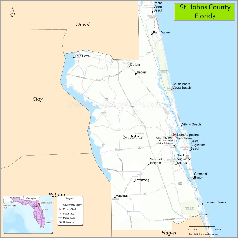
About St. Johns County Map, Florida: The map showing the county boundary, county seat, major cities, highways, water bodies and neighbouring counties.
Most Viewed Links
About St. Johns County, Florida
St. Johns County is located in the northeastern part of Florida, in the state of the United States. The county was established in 1821 and was named after the St. Johns River, which flows along part of its western boundary. The county seat and largest city is St. Augustine. St. Johns County is known for its historic landmarks, coastal communities, and strong residential growth.
Population
According to the United States Census Bureau, the population of St. Johns County is 273,425 as recorded in the 2020 Census, and the population density is approximately 341 people per square mile.
Area and Geography
According to the United States Census Bureau, St. Johns County covers a total area of approximately 822 square miles (about 2,129 square kilometers), including about 601 square miles (1,557 square kilometers) of land and 221 square miles (572 square kilometers) of water. The county features Atlantic Ocean coastline, barrier islands, the Intracoastal Waterway, and inland residential and agricultural areas.
Bordering Counties
St. Johns County shares boundaries with Duval County to the north, Clay County to the northwest, Putnam County to the west, Flagler County to the south, and the Atlantic Ocean to the east.
Major Cities and Communities
Major cities and towns include St. Augustine, St. Augustine Beach, Ponte Vedra Beach, Hastings, and Fruit Cove.
Attractions and Recreation
St. Johns County is widely recognized for historic St. Augustine, the Castillo de San Marcos National Monument, and its Atlantic beaches. The county also offers parks, golf courses, and waterfront recreation along the Intracoastal Waterway. Flagler College and St. Johns River State College provide higher education opportunities and contribute to the county’s academic environment.
Transportation
St. Johns County is served by Interstate 95, U.S. Highway 1, and State Road A1A, providing north-south coastal connectivity. Regional access is further supported by nearby Jacksonville International Airport.
Explore more counties in Florida Counties or view the complete USA States Map section for additional geographic information.
Sources:
Population and area data sourced from the United States Census Bureau (2020 Census). General county information referenced from the Official St. Johns County Government Website.
Facts about St. Johns County, Florida
| Country | United States |
| State | Florida |
| Region | Northeast Florida |
| County Seat | St. Augustine |
| Named After | St. Johns River |
| Established | 1821 |
| Organized | 1821 |
| Coordinates | 29.9020° N, 81.3840° W |
| Total Area | 822 sq mi |
| Land Area | 601 sq mi |
| Water Area | 221 sq mi |
| Population (2020) | 273,425 |
| Population Rank | Fast-growing county in Northeast Florida |
| Major City | St. Augustine |
| Main Industries | Tourism, Education, Healthcare, Professional Services |
| Major Airport | Northeast Florida Regional Airport |
| Time Zone | Eastern Time (UTC−05:00) |
| Known For | Oldest city in the U.S., historic sites, Atlantic beaches |
| Website | https://www.sjcfl.us |
Top Attractions in St. Johns County, Florida
- St. Augustine Historic District – Oldest city streets and landmarks.
- Castillo de San Marcos – Historic Spanish fort.
- St. Augustine Beach – Atlantic beaches and pier.
- St. George Street – Shops, dining, and history.
- Lightner Museum – Gilded Age art and exhibits.
- St. Augustine Lighthouse & Maritime Museum – Coastal views.
- Anastasia State Park – Beaches, trails, and kayaking.
- Fort Matanzas National Monument – Historic river fort.
- Vilano Beach – Quiet beach access.
- Scenic A1A Coastal Drive – Ocean and dune views.