Map of Manatee County - Manatee County is a county located in the U.S. state of Florida. Manatee County Map showing cities, highways, important places and water bodies. Get Where is Manatee County located in the map, major cities in Manatee county, population, areas, and places of interest.
Map of Manatee County, Florida
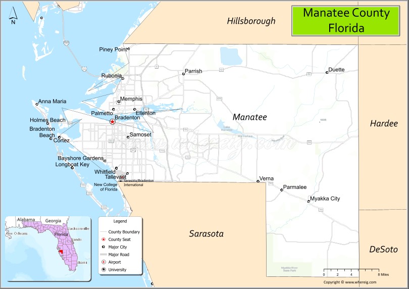
About Manatee County Map, Florida: The map showing the county boundary, county seat, major cities, highways, water bodies and neighbouring counties.
Most Viewed Links
About Manatee County, Florida
Manatee County is located in the west-central part of Florida, in the state of the United States. The county was established in 1855 and was named after the manatee, a marine mammal found in Florida’s coastal waters. The county seat and largest city is Bradenton. Manatee County is part of the North Port–Sarasota–Bradenton metropolitan area and is known for its Gulf Coast beaches, residential growth, and tourism industry.
Population
According to the United States Census Bureau, the population of Manatee County is 399,710 as recorded in the 2020 Census, and the population density is approximately 536 people per square mile.
Area and Geography
According to the United States Census Bureau, Manatee County covers a total area of approximately 893 square miles (about 2,313 square kilometers), including about 743 square miles (1,924 square kilometers) of land and 150 square miles (389 square kilometers) of water. The county features Gulf of Mexico coastline, barrier islands such as Anna Maria Island, rivers, and expanding suburban communities.
Bordering Counties
Manatee County shares boundaries with Hillsborough County to the north, Hardee County to the east, Sarasota County to the south, and the Gulf of Mexico to the west.
Major Cities and Communities
Major cities and towns include Bradenton, Palmetto, Anna Maria, Holmes Beach, and Lakewood Ranch.
Attractions and Recreation
Manatee County offers beaches, boating, fishing, and waterfront parks along the Gulf Coast and Tampa Bay. Cultural attractions, nature preserves, and sports facilities contribute to local tourism. The county is home to the State College of Florida, Manatee-Sarasota, and the University of South Florida Sarasota-Manatee campus, supporting higher education and workforce development in the region.
Transportation
Manatee County is served by Interstate 75 and U.S. Highway 41, providing north-south connectivity along Florida’s west coast. Sarasota Bradenton International Airport supports regional air travel and access to surrounding metropolitan areas.
Explore more counties in Florida Counties or view the complete USA States Map section for additional geographic information.
Sources:
Population and area data sourced from the United States Census Bureau (2020 Census). General county information referenced from the Official Manatee County Government Website.
Facts about Manatee County, Florida
| Country | United States |
| State | Florida |
| Region | West Central Florida (Suncoast) |
| County Seat | Bradenton |
| Named After | Manatee River / West Indian manatee |
| Established | 1855 |
| Organized | 1855 |
| Coordinates | 27.4956° N, 82.5739° W |
| Total Area | 893 sq mi |
| Land Area | 743 sq mi |
| Water Area | 150 sq mi |
| Population (2020) | 399,710 |
| Population Rank | One of the fastest-growing counties in Florida |
| Major City | Bradenton |
| Main Industries | Tourism, Healthcare, Agriculture, Manufacturing |
| Major Airport | Sarasota–Bradenton International Airport |
| Time Zone | Eastern Time (UTC−05:00) |
| Known For | Gulf Coast beaches, Anna Maria Island, Manatee River |
| Website | https://www.mymanatee.org |
Ctities in Manatee county
| City Name | Type | Population (2020) | Pop. Density | Area | Incorporated |
|---|---|---|---|---|---|
| Anna Maria | City | 968 | 1.0 sq mi (2.6 km2) | 1923 | |
| Bradenton | City | 55,698 | 14.4 sq mi (37.4 km2) | 1903 | |
| Bradenton Beach | City | 908 | 1.0 sq mi (2.8 km2) | 1952 | |
| Holmes Beach | City | 3,010 | 1.7 sq mi (4.5 km2) | 1950 | |
| Palmetto | City | 13,323 | 4.4 sq mi (11.5 km2) | 1897 | |
| Longboat Key | Town | 7,505 | 17.0 sq mi (44.2 km2) | 1955 |
Top Attractions in Manatee County, Florida
- Anna Maria Island – White sand beaches and sunsets.
- Robinson Preserve – Trails, kayaking, and wildlife.
- The Bishop Museum of Science and Nature – Planetarium and exhibits.
- Riverwalk (Bradenton) – Waterfront walking path.
- De Soto National Memorial – Historic exploration site.
- Manatee Village Historical Park – Preserved pioneer buildings.
- Cortez Fishing Village – Historic coastal community.
- Emerson Point Preserve – Scenic bay views and trails.
- Coquina Beach – Popular Gulf Coast beach.
- Bradenton Downtown – Dining, arts, and events.
Highways in Manatee
U.S. Route 19, U.S. Route 41, U.S. Route 301, State Road 64, State Road 70, State Road 684, State Road 789, State Road 62, State Road 37, .
Nearest Airports
Nearest airport of Manatee is Sarasota–Bradenton International Airport.
- Alachua County Map
- Baker County Map
- Bay County Map
- Bradford County Map
- Brevard County Map
- Broward County Map
- Calhoun County Map
- Charlotte County Map
- Citrus County Map
- Clay County Map
- Collier County Map
- Columbia County Map
- DeSoto County Map
- Dixie County Map
- Duval County Map
- Escambia County Map
- Flagler County Map
- Franklin County Map
- Gadsden County Map
- Gilchrist County Map
- Glades County Map
- Gulf County Map
- Hamilton County Map
- Hardee County Map
- Hendry County Map
- Hernando County Map
- Highlands County Map
- Hillsborough County Map
- Holmes County Map
- Indian River County Map
- Jackson County Map
- Jefferson County Map
- Lafayette County Map
- Lake County Map
- Lee County Map
- Leon County Map
- Levy County Map
- Liberty County Map
- Madison County Map
- Manatee County Map
- Marion County Map
- Martin County Map
- Miami-Dade County Map
- Monroe County Map
- Nassau County Map
- Okaloosa County Map
- Okeechobee County Map
- Orange County Map
- Osceola County Map
- Palm Beach County Map
- Pasco County Map
- Pinellas County Map
- Polk County Map
- Putnam County Map
- St Johns County Map
- St Lucie County Map
- Santa Rosa County Map
- Sarasota County Map
- Seminole County Map
- Sumter County Map
- Suwannee County Map
- Taylor County Map
- Union County Map
- Volusia County Map
- Wakulla County Map
- Walton County Map
- Washington County Map
- Where is Miami
- Where is Hialeah
- Where is Jacksonville
- Where is Orlando
- Where is Saint Petersburg
- Where is Tampa
- Where is Alafaya
- Where is Boca Raton
- Where is Boynton Beach
- Where is Brandon
- Where is Cape Coral
- Where is Clearwater
- Where is Coral Springs
- Where is Davie
- Where is Daytona Beach
- Where is Deerfield Beach
- Where is Deltona
- Where is Doral
- Where is Fort Lauderdale
- Where is Fort Myers
- Where is Gainesville
- Where is Hollywood
- Where is Homestead
- Where is Horizon West
- Where is Kendall
- Where is Kissimmee
- Where is Lakeland
- Where is Largo
- Where is Lauderhill
- Where is Lehigh Acres
- Where is Melbourne
- Where is Miami Beach
- Where is Miami Gardens
- Where is Miramar
- Where is North Port
- Where is Palm Bay
- Where is Palm Coast
- Where is Pembroke Pines
- Where is Plantation
- Where is Poinciana
- Where is Pompano Beach
- Where is Port St. Lucie
- Where is Riverview
- Where is Spring Hill
- Where is St. Petersburg
- Where is Sunrise
- Where is Tallahassee
- Where is Tamarac
- Where is The Villages
- Where is Town 'n' Country
- Where is West Palm Beach