Map of Sarasota County - Sarasota County is a county located in the U.S. state of Florida. Sarasota County Map showing cities, highways, important places and water bodies. Get Where is Sarasota County located in the map, major cities in Sarasota county, population, areas, and places of interest.
Map of Sarasota County, Florida
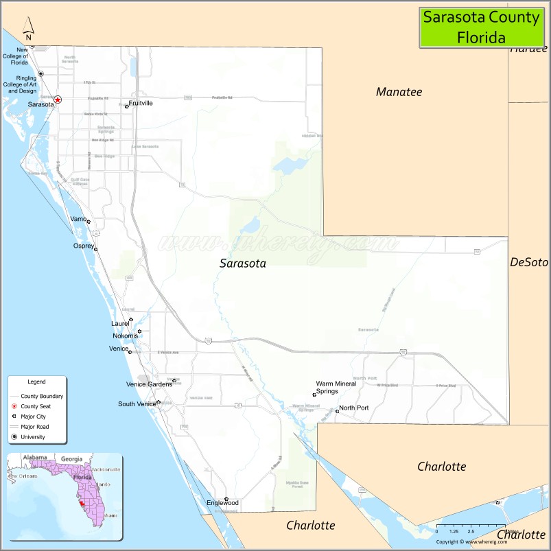
About Sarasota County Map, Florida: The map showing the county boundary, county seat, major cities, highways, water bodies and neighbouring counties.
Most Viewed Links
About Sarasota County, Florida
Sarasota County is located in the southwestern part of Florida, in the state of the United States. The county was established in 1921 and was named after the Sarasota area, a name believed to have Native American origins. The county seat is Sarasota, and the largest city is North Port. Sarasota County is known for its Gulf Coast beaches, cultural institutions, and strong tourism-driven economy.
Population
According to the United States Census Bureau, the population of Sarasota County is 434,006 as recorded in the 2020 Census, and the population density is approximately 779 people per square mile.
Area and Geography
According to the United States Census Bureau, Sarasota County covers a total area of approximately 725 square miles (about 1,878 square kilometers), including about 556 square miles (1,440 square kilometers) of land and 169 square miles (438 square kilometers) of water. The county features Gulf of Mexico coastline, barrier islands such as Siesta Key and Casey Key, and inland residential communities.
Bordering Counties
Sarasota County shares boundaries with Manatee County to the north, Hardee County to the northeast, DeSoto County to the east, and Charlotte County to the south.
Major Cities and Communities
Major cities and towns include Sarasota, North Port, Venice, Longboat Key, and Englewood.
Attractions and Recreation
Sarasota County is widely recognized for Siesta Beach, cultural venues such as museums and performing arts centers, and outdoor recreation along its coastline and waterways. The county is also home to higher education institutions including the State College of Florida, Manatee-Sarasota and Ringling College of Art and Design, contributing to academic programs and workforce development in the region.
Transportation
Sarasota County is served by Interstate 75, U.S. Highway 41, and U.S. Highway 301, providing regional connectivity throughout Southwest Florida. Sarasota Bradenton International Airport supports commercial air travel and regional access.
Explore more counties in Florida Counties or view the complete USA States Map section for additional geographic information.
Sources:
Population and area data sourced from the United States Census Bureau (2020 Census). General county information referenced from the Official Sarasota County Government Website.
Facts about Sarasota County, Florida
| Country | United States |
| State | Florida |
| Region | Southwest Florida (Suncoast) |
| County Seat | Sarasota |
| Named After | Sarasota Bay |
| Established | 1921 |
| Organized | 1921 |
| Coordinates | 27.3375° N, 82.5430° W |
| Total Area | 725 sq mi |
| Land Area | 556 sq mi |
| Water Area | 169 sq mi |
| Population (2020) | 434,006 |
| Population Rank | One of the fastest-growing counties in Southwest Florida |
| Major City | Sarasota |
| Main Industries | Tourism, Healthcare, Arts & Culture, Real Estate |
| Major Airport | Sarasota–Bradenton International Airport |
| Time Zone | Eastern Time (UTC−05:00) |
| Known For | Siesta Key Beach, arts scene, barrier islands |
| Website | https://www.scgov.net |
Ctities in Sarasota county
| City Name | Type | Population (2020) | Pop. Density | Area | Incorporated |
|---|---|---|---|---|---|
| Longboat Key | Town | 7,505 | 17.0 sq mi (44.2 km2) | 1955 | |
| North Port | City | 74,793 | 75.6 sq mi (195.7 km2) | 1959 | |
| Sarasota | City | 54,842 | 25.9 sq mi (67.2 km2) | 1902 | |
| Venice | City | 25,463 | 9.6 sq mi (25.0 km2) | 1926 |
Top Attractions in Sarasota County, Florida
- Siesta Key Beach – Powdery white sand beaches.
- The Ringling – Art museum and historic estate.
- Marie Selby Botanical Gardens – Bayfront gardens and exhibits.
- St. Armands Circle – Shopping, dining, and charm.
- Myakka River State Park – Wildlife viewing and airboat tours.
- Venice Beach – Shark tooth hunting.
- Sarasota Jungle Gardens – Tropical wildlife park.
- Downtown Sarasota – Arts, dining, and waterfront.
- Lido Key Beach – Gulf beach and sunsets.
- Oscar Scherer State Park – Trails and camping.
Highways in Sarasota
Interstate 75, U.S. Highway 41, U.S. Highway 301, State Road 789 , State Road 758, State Road 780, State Road 776 , State Road 72, State Road 681 .
Nearest Airports
Nearest airport of Sarasota are Sarasota-Bradenton International Airport,Venice Municipal Airport,Buchan Airport.
- Alachua County Map
- Baker County Map
- Bay County Map
- Bradford County Map
- Brevard County Map
- Broward County Map
- Calhoun County Map
- Charlotte County Map
- Citrus County Map
- Clay County Map
- Collier County Map
- Columbia County Map
- DeSoto County Map
- Dixie County Map
- Duval County Map
- Escambia County Map
- Flagler County Map
- Franklin County Map
- Gadsden County Map
- Gilchrist County Map
- Glades County Map
- Gulf County Map
- Hamilton County Map
- Hardee County Map
- Hendry County Map
- Hernando County Map
- Highlands County Map
- Hillsborough County Map
- Holmes County Map
- Indian River County Map
- Jackson County Map
- Jefferson County Map
- Lafayette County Map
- Lake County Map
- Lee County Map
- Leon County Map
- Levy County Map
- Liberty County Map
- Madison County Map
- Manatee County Map
- Marion County Map
- Martin County Map
- Miami-Dade County Map
- Monroe County Map
- Nassau County Map
- Okaloosa County Map
- Okeechobee County Map
- Orange County Map
- Osceola County Map
- Palm Beach County Map
- Pasco County Map
- Pinellas County Map
- Polk County Map
- Putnam County Map
- St Johns County Map
- St Lucie County Map
- Santa Rosa County Map
- Sarasota County Map
- Seminole County Map
- Sumter County Map
- Suwannee County Map
- Taylor County Map
- Union County Map
- Volusia County Map
- Wakulla County Map
- Walton County Map
- Washington County Map
- Where is Miami
- Where is Hialeah
- Where is Jacksonville
- Where is Orlando
- Where is Saint Petersburg
- Where is Tampa
- Where is Alafaya
- Where is Boca Raton
- Where is Boynton Beach
- Where is Brandon
- Where is Cape Coral
- Where is Clearwater
- Where is Coral Springs
- Where is Davie
- Where is Daytona Beach
- Where is Deerfield Beach
- Where is Deltona
- Where is Doral
- Where is Fort Lauderdale
- Where is Fort Myers
- Where is Gainesville
- Where is Hollywood
- Where is Homestead
- Where is Horizon West
- Where is Kendall
- Where is Kissimmee
- Where is Lakeland
- Where is Largo
- Where is Lauderhill
- Where is Lehigh Acres
- Where is Melbourne
- Where is Miami Beach
- Where is Miami Gardens
- Where is Miramar
- Where is North Port
- Where is Palm Bay
- Where is Palm Coast
- Where is Pembroke Pines
- Where is Plantation
- Where is Poinciana
- Where is Pompano Beach
- Where is Port St. Lucie
- Where is Riverview
- Where is Spring Hill
- Where is St. Petersburg
- Where is Sunrise
- Where is Tallahassee
- Where is Tamarac
- Where is The Villages
- Where is Town 'n' Country
- Where is West Palm Beach