Map of Calhoun County - Calhoun County is a county located in the U.S. state of Florida. Calhoun County Map showing cities, highways, important places and water bodies. Get Where is Calhoun County located in the map, major cities in Calhoun county, population, areas, and places of interest.
Map of Calhoun County, Florida
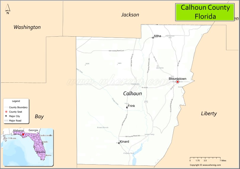
About Calhoun County Map, Florida: The map showing the county boundary, county seat, major cities, highways, water bodies and neighbouring counties.
Most Viewed Links
About Calhoun County, Florida
Calhoun County is located in the Florida Panhandle region of Florida, United States. The county was established in 1838 and was named after John C. Calhoun, a prominent American statesman. The county seat and largest city is Blountstown, which serves as the primary center for government, commerce, and community services. Calhoun County is known for its rural landscapes, forests, and strong agricultural traditions.
Population
According to the United States Census Bureau, the population of Calhoun County was 13,648 as recorded in the 2020 Census. The population is primarily concentrated in Blountstown, with smaller communities spread throughout the county.
Area and Geography
According to the United States Census Bureau, Calhoun County covers a total area of approximately 574 square miles (about 1,486 square kilometers), including about 567 square miles (1,468 square kilometers) of land and 7 square miles (18 square kilometers) of water. The county features river systems, forested areas, and agricultural lands typical of the Florida Panhandle.
Bordering Counties
Calhoun County shares borders with Jackson County to the west, Liberty County to the south, Gadsden County to the east, and Gulf County to the southwest.
Major Cities and Communities
The principal communities in Calhoun County include Blountstown, Altha, and Clarksville, which serve as residential and agricultural centers within the county.
Attractions and Recreation
Calhoun County offers outdoor recreation opportunities including fishing, boating, and camping along the Apalachicola River and Chipola River. Forested areas and natural preserves provide access to hiking, hunting, and wildlife viewing.
Transportation
Major transportation routes serving Calhoun County include State Road 20 and State Road 71, providing connections to neighboring counties and other parts of the Florida Panhandle.
Explore more counties in Florida Counties or view the complete USA States Map section for additional geographic information.
Sources:
Population and area data sourced from the United States Census Bureau (2020 Census). General county information referenced from the Official Calhoun County Government Website.
Facts about Calhoun County, Florida
| Country | United States |
| State | Florida |
| Region | Florida Panhandle |
| County Seat | Blountstown |
| Named After | John C. Calhoun |
| Established | 1858 |
| Organized | 1858 |
| Coordinates | 30.4066° N, 85.1977° W |
| Total Area | 567 sq mi |
| Land Area | 566 sq mi |
| Water Area | 1 sq mi |
| Population (2020) | 13,648 |
| Population Rank | Small, rural county in Northwest Florida |
| Major City | Blountstown |
| Main Industries | Agriculture, Forestry, Corrections, Public Services |
| Major Airport | Calhoun County Airport |
| Time Zone | Central Time (UTC−06:00) |
| Known For | Chipola River, farming communities, rural landscapes |
| Website | https://www.calhounco.org |
Ctities in Calhoun county
| City Name | Type | Population (2020) | Pop. Density | Area | Incorporated |
|---|---|---|---|---|---|
| Altha | Town | 496 | 1.4 sq mi (3.6 km2) | 1946 | |
| Blountstown | City | 2,266 | 3.2 sq mi (8.3 km2) | 1903 | |
| Anniston | City | 21,564 | 472.5/sq mi (182.4/km2) | 45.64 sq mi (118.2 km2) | |
| Hobson City | Town | 759 | 729.8/sq mi (281.8/km2) | 1.04 sq mi (2.7 km2) | |
| Jacksonville | City | 14,385 | 1,461.9/sq mi (564.4/km2) | 9.84 sq mi (25.5 km2) | |
| Ohatchee | Town | 1,157 | 196.1/sq mi (75.7/km2) | 5.9 sq mi (15.3 km2) | |
| Weaver | City | 3,339 | 962.2/sq mi (371.5/km2) | 3.47 sq mi (9 km2) | |
| Piedmont | City | 4,787 | 488.0/sq mi (188.4/km2) | 9.81 sq mi (25.4 km2) | |
| Oxford | City | 22,069 | 719.6/sq mi (277.8/km2) | 30.67 sq mi (79.4 km2) | |
| Glencoe | City | 5,372 | 317.3/sq mi (122.5/km2) | 16.93 sq mi (43.8 km2) | |
| Southside | City | 9,426 | 496.6/sq mi (191.7/km2) | 18.98 sq mi (49.2 km2) |
Top Attractions in Calhoun County, Florida
- Chipola River – Canoeing, fishing, and river views.
- Florida Caverns State Park – Limestone caves and hiking trails.
- Downtown Blountstown – Shops and small-town charm.
- Calhoun County Courthouse – Historic courthouse landmark.
- Sam Atkins Park – Green space and recreation.
- Altha Downtown Area – Rural town history and shops.
- Apalachicola River (nearby access) – Fishing and wildlife viewing.
- Rural Farmland Drives – Scenic countryside views.
- Community Parks – Picnic areas and walking paths.
- Local Nature Trails – Birdwatching and outdoor walks.
- Alachua County Map
- Baker County Map
- Bay County Map
- Bradford County Map
- Brevard County Map
- Broward County Map
- Calhoun County Map
- Charlotte County Map
- Citrus County Map
- Clay County Map
- Collier County Map
- Columbia County Map
- DeSoto County Map
- Dixie County Map
- Duval County Map
- Escambia County Map
- Flagler County Map
- Franklin County Map
- Gadsden County Map
- Gilchrist County Map
- Glades County Map
- Gulf County Map
- Hamilton County Map
- Hardee County Map
- Hendry County Map
- Hernando County Map
- Highlands County Map
- Hillsborough County Map
- Holmes County Map
- Indian River County Map
- Jackson County Map
- Jefferson County Map
- Lafayette County Map
- Lake County Map
- Lee County Map
- Leon County Map
- Levy County Map
- Liberty County Map
- Madison County Map
- Manatee County Map
- Marion County Map
- Martin County Map
- Miami-Dade County Map
- Monroe County Map
- Nassau County Map
- Okaloosa County Map
- Okeechobee County Map
- Orange County Map
- Osceola County Map
- Palm Beach County Map
- Pasco County Map
- Pinellas County Map
- Polk County Map
- Putnam County Map
- St Johns County Map
- St Lucie County Map
- Santa Rosa County Map
- Sarasota County Map
- Seminole County Map
- Sumter County Map
- Suwannee County Map
- Taylor County Map
- Union County Map
- Volusia County Map
- Wakulla County Map
- Walton County Map
- Washington County Map
- Where is Miami
- Where is Hialeah
- Where is Jacksonville
- Where is Orlando
- Where is Saint Petersburg
- Where is Tampa
- Where is Alafaya
- Where is Boca Raton
- Where is Boynton Beach
- Where is Brandon
- Where is Cape Coral
- Where is Clearwater
- Where is Coral Springs
- Where is Davie
- Where is Daytona Beach
- Where is Deerfield Beach
- Where is Deltona
- Where is Doral
- Where is Fort Lauderdale
- Where is Fort Myers
- Where is Gainesville
- Where is Hollywood
- Where is Homestead
- Where is Horizon West
- Where is Kendall
- Where is Kissimmee
- Where is Lakeland
- Where is Largo
- Where is Lauderhill
- Where is Lehigh Acres
- Where is Melbourne
- Where is Miami Beach
- Where is Miami Gardens
- Where is Miramar
- Where is North Port
- Where is Palm Bay
- Where is Palm Coast
- Where is Pembroke Pines
- Where is Plantation
- Where is Poinciana
- Where is Pompano Beach
- Where is Port St. Lucie
- Where is Riverview
- Where is Spring Hill
- Where is St. Petersburg
- Where is Sunrise
- Where is Tallahassee
- Where is Tamarac
- Where is The Villages
- Where is Town 'n' Country
- Where is West Palm Beach