Map of Pinellas County - Pinellas County is a county located in the U.S. state of Florida. Pinellas County Map showing cities, highways, important places and water bodies. Get Where is Pinellas County located in the map, major cities in Pinellas county, population, areas, and places of interest.
Map of Pinellas County, Florida
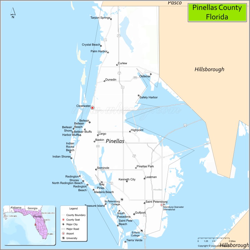
About Pinellas County Map, Florida: The map showing the county boundary, county seat, major cities, highways, water bodies and neighbouring counties.
Most Viewed Links
About Pinellas County, Florida
Pinellas County is located in the west-central part of Florida, in the state of the United States. The county was established in 1912 and was named from a Spanish term meaning “point of pines,” reflecting the area’s early landscape. The county seat is Clearwater, and the largest city is St. Petersburg. Pinellas County is part of the Tampa Bay metropolitan area and is known for its Gulf Coast beaches, dense urban development, and vibrant tourism industry.
Population
According to the United States Census Bureau, the population of Pinellas County is 959,107 as recorded in the 2020 Census, and the population density is approximately 3,491 people per square mile.
Area and Geography
According to the United States Census Bureau, Pinellas County covers a total area of approximately 608 square miles (about 1,575 square kilometers), including about 274 square miles (710 square kilometers) of land and 334 square miles (865 square kilometers) of water. The county occupies a peninsula between the Gulf of Mexico and Tampa Bay, featuring barrier islands, beaches, coastal communities, and urban centers.
Bordering Counties
Pinellas County shares boundaries with Pasco County to the north and Hillsborough County to the east.
Major Cities and Communities
Major cities and towns include St. Petersburg, Clearwater, Largo, Pinellas Park, Dunedin, and Tarpon Springs.
Attractions and Recreation
Pinellas County is widely recognized for Clearwater Beach and St. Pete Beach, along with waterfront parks, museums, and cultural attractions in St. Petersburg. Boating, fishing, beach activities, and nature trails throughout the peninsula support year-round tourism and outdoor recreation.
Transportation
Pinellas County is connected to surrounding regions by major bridges across Tampa Bay, including routes linking to Hillsborough County. U.S. Highway 19 and Interstate 275 provide north-south connectivity, while St. Pete–Clearwater International Airport supports regional air travel.
Explore more counties in Florida Counties or view the complete USA States Map section for additional geographic information.
Sources:
Population and area data sourced from the United States Census Bureau (2020 Census). General county information referenced from the Official Pinellas County Government Website.
Facts about Pinellas County, Florida
| Country | United States |
| State | Florida |
| Region | West Central Florida (Tampa Bay) |
| County Seat | Clearwater |
| Named After | Spanish word “Punta Piñal” (Point of Pines) |
| Established | 1912 |
| Organized | 1912 |
| Coordinates | 27.9031° N, 82.7395° W |
| Total Area | 608 sq mi |
| Land Area | 274 sq mi |
| Water Area | 334 sq mi |
| Population (2020) | 959,107 |
| Population Rank | Second most populous county in Florida |
| Major City | St. Petersburg |
| Main Industries | Tourism, Healthcare, Financial Services, Technology |
| Major Airport | St. Pete–Clearwater International Airport |
| Time Zone | Eastern Time (UTC−05:00) |
| Known For | Gulf beaches, Clearwater Beach, St. Petersburg arts and culture |
| Website | https://www.pinellascounty.org |
Ctities in Pinellas county
| City Name | Type | Population (2020) | Pop. Density | Area | Incorporated |
|---|---|---|---|---|---|
| Belleair | Town | 4,273 | 2.8 sq mi (7.3 km2) | 1924 | |
| Belleair Beach | City | 1,633 | 1.8 sq mi (4.5 km2) | 1950 | |
| Belleair Bluffs | City | 2,311 | 0.7 sq mi (1.6 km2) | 1963 | |
| Belleair Shore | Town | 73 | 0.5 sq mi (1.1 km2) | 1955 | |
| Clearwater | City | 117,292 | 37.7 sq mi (97.7 km2) | 1891 | |
| Dunedin | City | 36,068 | 28.2 sq mi (73.1 km2) | 1899 | |
| Gulfport | City | 11,783 | 3.8 sq mi (9.9 km2) | 1910 | |
| Indian Rocks Beach | City | 4,286 | 1.4 sq mi (3.6 km2) | 1956 | |
| Indian Shores | Town | 1,190 | 0.9 sq mi (2.5 km2) | 1949 | |
| Kenneth City | Town | 5,047 | 0.7 sq mi (1.9 km2) | 1957 | |
| Largo | City | 82,485 | 16.1 sq mi (41.8 km2) | 1905 | |
| Madeira Beach | City | 3,895 | 3.2 sq mi (8.5 km2) | 1947 | |
| North Redington Beach | Town | 1,495 | 1.0 sq mi (2.7 km2) | 1953 | |
| Oldsmar | City | 14,898 | 9.7 sq mi (25.0 km2) | 1936 | |
| Pinellas Park | City | 53,093 | 14.9 sq mi (38.7 km2) | 1915 | |
| Redington Beach | Town | 1,376 | 1.3 sq mi (3.3 km2) | 1944 | |
| Redington Shores | Town | 2,176 | 1.2 sq mi (3.1 km2) | 1955 | |
| Safety Harbor | City | 17,072 | 5.0 sq mi (13.0 km2) | 1917 | |
| Seminole | City | 19,364 | 2.7 sq mi (7.0 km2) | 1970 | |
| South Pasadena | City | 5,353 | 1.2 sq mi (3.0 km2) | 1955 | |
| St. Pete Beach | City | 8,879 | 19.8 sq mi (51.5 km2) | 1957 | |
| St. Petersburg | City | 258,308 | 132.6 sq mi (344.7 km2) | 1903 | |
| Tarpon Springs | City | 25,117 | 16.8 sq mi (43.8 km2) | 1887 | |
| Treasure Island | City | 6,584 | 5.3 sq mi (13.8 km2) | 1955 |
Top Attractions in Pinellas County, Florida
- Clearwater Beach – White sand beaches and sunsets.
- St. Pete Beach – Gulf Coast swimming and resorts.
- The Dalí Museum – World-renowned surrealist art.
- Downtown St. Petersburg – Waterfront dining and arts.
- Fort De Soto Park – Beaches, trails, and historic fort.
- John’s Pass Village & Boardwalk – Shops, dining, and marina.
- Sunken Gardens – Historic botanical gardens.
- Clearwater Marine Aquarium – Marine rescue and exhibits.
- Honeymoon Island State Park – Natural beaches and wildlife.
- St. Pete Pier – Waterfront park and attractions.
Highways in Pinellas
I-175 / SR 594, I-275 / SR 93, I-375, US 19, US 19 , SR 595, US 92, SR 60, SR 580, SR 586, SR 590, SR 679, SR 682, SR 686, SR 687, SR 688, SR 689, SR 693, SR 694, SR 699.
Nearest Airports
Nearest airport of Pinellas is St. Petersburg–Clearwater International Airport.
- Alachua County Map
- Baker County Map
- Bay County Map
- Bradford County Map
- Brevard County Map
- Broward County Map
- Calhoun County Map
- Charlotte County Map
- Citrus County Map
- Clay County Map
- Collier County Map
- Columbia County Map
- DeSoto County Map
- Dixie County Map
- Duval County Map
- Escambia County Map
- Flagler County Map
- Franklin County Map
- Gadsden County Map
- Gilchrist County Map
- Glades County Map
- Gulf County Map
- Hamilton County Map
- Hardee County Map
- Hendry County Map
- Hernando County Map
- Highlands County Map
- Hillsborough County Map
- Holmes County Map
- Indian River County Map
- Jackson County Map
- Jefferson County Map
- Lafayette County Map
- Lake County Map
- Lee County Map
- Leon County Map
- Levy County Map
- Liberty County Map
- Madison County Map
- Manatee County Map
- Marion County Map
- Martin County Map
- Miami-Dade County Map
- Monroe County Map
- Nassau County Map
- Okaloosa County Map
- Okeechobee County Map
- Orange County Map
- Osceola County Map
- Palm Beach County Map
- Pasco County Map
- Pinellas County Map
- Polk County Map
- Putnam County Map
- St Johns County Map
- St Lucie County Map
- Santa Rosa County Map
- Sarasota County Map
- Seminole County Map
- Sumter County Map
- Suwannee County Map
- Taylor County Map
- Union County Map
- Volusia County Map
- Wakulla County Map
- Walton County Map
- Washington County Map
- Where is Miami
- Where is Hialeah
- Where is Jacksonville
- Where is Orlando
- Where is Saint Petersburg
- Where is Tampa
- Where is Alafaya
- Where is Boca Raton
- Where is Boynton Beach
- Where is Brandon
- Where is Cape Coral
- Where is Clearwater
- Where is Coral Springs
- Where is Davie
- Where is Daytona Beach
- Where is Deerfield Beach
- Where is Deltona
- Where is Doral
- Where is Fort Lauderdale
- Where is Fort Myers
- Where is Gainesville
- Where is Hollywood
- Where is Homestead
- Where is Horizon West
- Where is Kendall
- Where is Kissimmee
- Where is Lakeland
- Where is Largo
- Where is Lauderhill
- Where is Lehigh Acres
- Where is Melbourne
- Where is Miami Beach
- Where is Miami Gardens
- Where is Miramar
- Where is North Port
- Where is Palm Bay
- Where is Palm Coast
- Where is Pembroke Pines
- Where is Plantation
- Where is Poinciana
- Where is Pompano Beach
- Where is Port St. Lucie
- Where is Riverview
- Where is Spring Hill
- Where is St. Petersburg
- Where is Sunrise
- Where is Tallahassee
- Where is Tamarac
- Where is The Villages
- Where is Town 'n' Country
- Where is West Palm Beach