Map of DeSoto County - DeSoto County is a county located in the U.S. state of Florida. DeSoto County Map showing cities, highways, important places and water bodies. Get Where is DeSoto County located in the map, major cities in DeSoto county, population, areas, and places of interest.
Map of DeSoto County, Florida
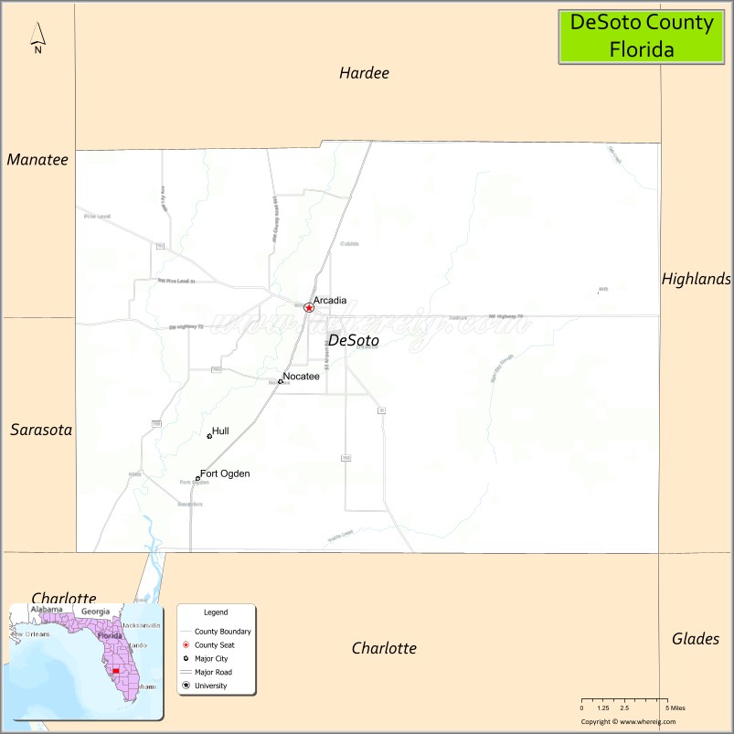
About DeSoto County Map, Florida: The map showing the county boundary, county seat, major cities, highways, water bodies and neighbouring counties.
Most Viewed Links
About DeSoto County, Florida
DeSoto County is located in the south-central part of Florida, in the state of the United States. The county was established in 1887 and was named after Hernando de Soto, a Spanish explorer who traveled through parts of the southeastern region. The county seat and largest city is Arcadia. DeSoto County has a strong agricultural base, with cattle ranching and citrus production playing important roles in the local economy.
Population
According to the United States Census Bureau, the population of DeSoto County was 33,976 as recorded in the 2020 Census.
Area and Geography
According to the United States Census Bureau, DeSoto County covers a total area of approximately 639 square miles (about 1,655 square kilometers), including about 637 square miles (1,650 square kilometers) of land and 2 square miles (5 square kilometers) of water. The county features mostly flat terrain typical of central Florida, with the Peace River flowing through the region and supporting both agriculture and outdoor recreation.
Bordering Counties
DeSoto County shares boundaries with Hardee County to the north, Highlands County to the east, Charlotte County to the south, Sarasota County to the west, and Manatee County to the northwest.
Major Cities and Communities
Major cities and towns include Arcadia, Nocatee, Fort Ogden, and Lake Suzy.
Attractions and Recreation
DeSoto County offers outdoor recreation centered around the Peace River, which is popular for canoeing, kayaking, and fossil hunting. Historic downtown Arcadia features preserved architecture and local shops, while parks and rural landscapes throughout the county provide opportunities for hiking, camping, and wildlife observation.
Transportation
Transportation in DeSoto County is supported by U.S. Highway 17, which runs north-south through Arcadia, and State Road 70, providing east-west connectivity. These routes connect the county with neighboring regions and support agricultural and commercial activity.
Explore more counties in Florida Counties or view the complete USA States Map section for additional geographic information.
Sources:
Population and area data sourced from the United States Census Bureau (2020 Census). General county information referenced from the Official DeSoto County Government Website.
Facts about DeSoto County, Florida
| Country | United States |
| State | Florida |
| Region | South Central Florida |
| County Seat | Arcadia |
| Named After | Hernando de Soto |
| Established | 1887 |
| Organized | 1887 |
| Coordinates | 27.1865° N, 81.8090° W |
| Total Area | 639 sq mi |
| Land Area | 637 sq mi |
| Water Area | 2 sq mi |
| Population (2020) | 33,976 |
| Population Rank | Small, rural county in South Central Florida |
| Major City | Arcadia |
| Main Industries | Agriculture, Food Processing, Manufacturing |
| Major Airport | Arcadia Municipal Airport |
| Time Zone | Eastern Time (UTC−05:00) |
| Known For | Cattle ranching, Peace River, historic downtown Arcadia |
| Website | https://www.desotobocc.com |
Ctities in DeSoto county
| City Name | Type | Population (2020) | Pop. Density | Area | Incorporated |
|---|---|---|---|---|---|
| Arcadia | City | 7,420 | 4.0 sq mi (10.5 km2) | 1886 |
Top Attractions in DeSoto County, Florida
- Peace River – Canoeing, fishing, and fossil hunting.
- Brownville Park – Riverfront trails and picnicking.
- Downtown Arcadia Historic District – Antiques and local charm.
- DeSoto County Courthouse – Historic courthouse landmark.
- Turner Agri-Civic Center – Rodeos and community events.
- Military Heritage Museum (Arcadia) – Veterans and military history.
- Nav-A-Gator Grill & Marina – Waterfront dining and views.
- Joshua Creek Preserve – Hiking and wildlife viewing.
- Local Antique Shops – Popular antique shopping spots.
- Scenic Rural Drives – Open countryside landscapes.
Highways in DeSoto
Interstate 75, U.S. Route 17, State Road 31, State Road 70, State Road 72.
Nearest Airports
Nearest airport of DeSoto is Arcadia Municipal Airport.
- Alachua County Map
- Baker County Map
- Bay County Map
- Bradford County Map
- Brevard County Map
- Broward County Map
- Calhoun County Map
- Charlotte County Map
- Citrus County Map
- Clay County Map
- Collier County Map
- Columbia County Map
- DeSoto County Map
- Dixie County Map
- Duval County Map
- Escambia County Map
- Flagler County Map
- Franklin County Map
- Gadsden County Map
- Gilchrist County Map
- Glades County Map
- Gulf County Map
- Hamilton County Map
- Hardee County Map
- Hendry County Map
- Hernando County Map
- Highlands County Map
- Hillsborough County Map
- Holmes County Map
- Indian River County Map
- Jackson County Map
- Jefferson County Map
- Lafayette County Map
- Lake County Map
- Lee County Map
- Leon County Map
- Levy County Map
- Liberty County Map
- Madison County Map
- Manatee County Map
- Marion County Map
- Martin County Map
- Miami-Dade County Map
- Monroe County Map
- Nassau County Map
- Okaloosa County Map
- Okeechobee County Map
- Orange County Map
- Osceola County Map
- Palm Beach County Map
- Pasco County Map
- Pinellas County Map
- Polk County Map
- Putnam County Map
- St Johns County Map
- St Lucie County Map
- Santa Rosa County Map
- Sarasota County Map
- Seminole County Map
- Sumter County Map
- Suwannee County Map
- Taylor County Map
- Union County Map
- Volusia County Map
- Wakulla County Map
- Walton County Map
- Washington County Map
- Where is Miami
- Where is Hialeah
- Where is Jacksonville
- Where is Orlando
- Where is Saint Petersburg
- Where is Tampa
- Where is Alafaya
- Where is Boca Raton
- Where is Boynton Beach
- Where is Brandon
- Where is Cape Coral
- Where is Clearwater
- Where is Coral Springs
- Where is Davie
- Where is Daytona Beach
- Where is Deerfield Beach
- Where is Deltona
- Where is Doral
- Where is Fort Lauderdale
- Where is Fort Myers
- Where is Gainesville
- Where is Hollywood
- Where is Homestead
- Where is Horizon West
- Where is Kendall
- Where is Kissimmee
- Where is Lakeland
- Where is Largo
- Where is Lauderhill
- Where is Lehigh Acres
- Where is Melbourne
- Where is Miami Beach
- Where is Miami Gardens
- Where is Miramar
- Where is North Port
- Where is Palm Bay
- Where is Palm Coast
- Where is Pembroke Pines
- Where is Plantation
- Where is Poinciana
- Where is Pompano Beach
- Where is Port St. Lucie
- Where is Riverview
- Where is Spring Hill
- Where is St. Petersburg
- Where is Sunrise
- Where is Tallahassee
- Where is Tamarac
- Where is The Villages
- Where is Town 'n' Country
- Where is West Palm Beach