Map of Putnam County - Putnam County is a county located in the U.S. state of Florida. Putnam County Map showing cities, highways, important places and water bodies. Get Where is Putnam County located in the map, major cities in Putnam county, population, areas, and places of interest.
Map of Putnam County, Florida
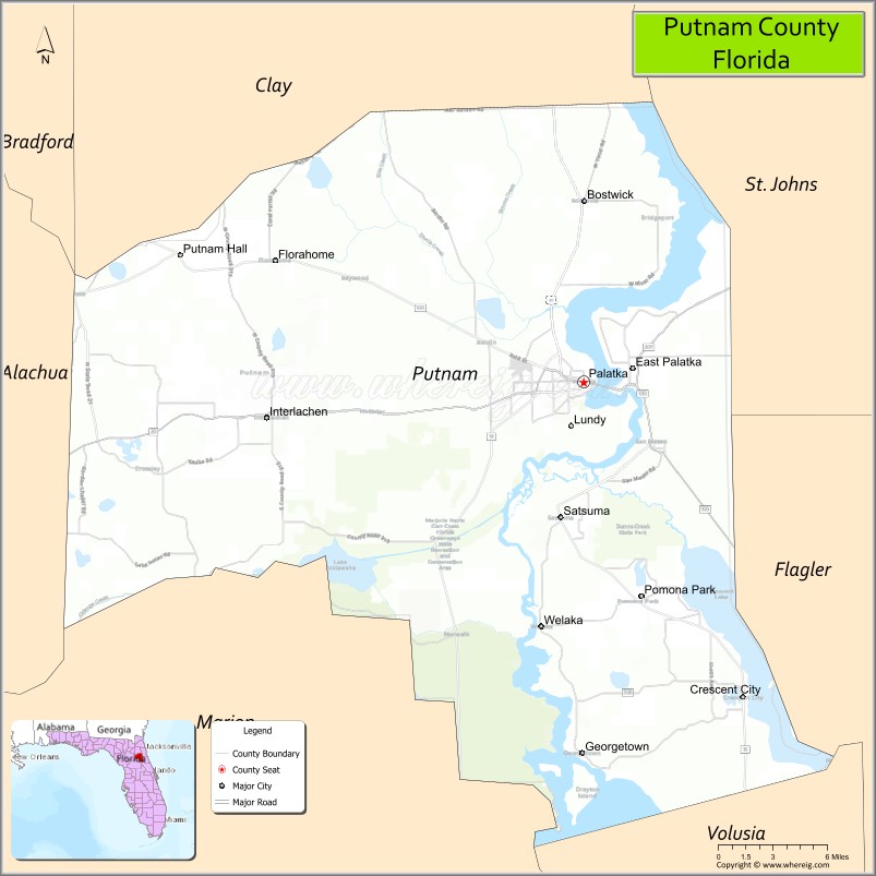
About Putnam County Map, Florida: The map showing the county boundary, county seat, major cities, highways, water bodies and neighbouring counties.
Most Viewed Links
About Putnam County, Florida
Putnam County is located in the northeastern part of Florida, in the state of the United States. The county was established in 1849 and was named after Benjamin A. Putnam, a Florida soldier and legislator. The county seat is Palatka, which is also the largest city. Putnam County is known for its riverfront communities, historic districts, and agricultural traditions.
Population
According to the United States Census Bureau, the population of Putnam County is 73,321 as recorded in the 2020 Census, and the population density is approximately 101 people per square mile.
Area and Geography
According to the United States Census Bureau, Putnam County covers a total area of approximately 827 square miles (about 2,142 square kilometers), including about 728 square miles (1,886 square kilometers) of land and 99 square miles (256 square kilometers) of water. The county features portions of the St. Johns River, numerous lakes, forested lands, and rural landscapes typical of inland Northeast Florida.
Bordering Counties
Putnam County shares boundaries with Clay County to the north, St. Johns County to the northeast, Flagler County to the east, Volusia County to the south, Marion County to the southwest, Alachua County to the west, and Bradford County to the northwest.
Major Cities and Communities
Major cities and towns include Palatka, Crescent City, Interlachen, Pomona Park, and Welaka.
Attractions and Recreation
Putnam County offers outdoor recreation centered around the St. Johns River and its numerous lakes, making it popular for boating, fishing, and water sports. Ravine Gardens State Park in Palatka features landscaped gardens and scenic walking trails. The county is also home to St. Johns River State College, which provides higher education opportunities and workforce development programs for residents.
Transportation
Putnam County is served by U.S. Highway 17, U.S. Highway 19, and State Road 20, providing regional connectivity across Northeast Florida. These routes support local commerce and access to neighboring counties.
Explore more counties in Florida Counties or view the complete USA States Map section for additional geographic information.
Sources:
Population and area data sourced from the United States Census Bureau (2020 Census). General county information referenced from the Official Putnam County Government Website.
Facts about Putnam County, Florida
| Country | United States |
| State | Florida |
| Region | Northeast Florida |
| County Seat | Palatka |
| Named After | Israel Putnam |
| Established | 1849 |
| Organized | 1849 |
| Coordinates | 29.6486° N, 81.7210° W |
| Total Area | 827 sq mi |
| Land Area | 728 sq mi |
| Water Area | 99 sq mi |
| Population (2020) | 73,321 |
| Population Rank | Mid-sized county in Northeast Florida |
| Major City | Palatka |
| Main Industries | Agriculture, Manufacturing, Forestry, Public Services |
| Major Airport | Putnam County Airport |
| Time Zone | Eastern Time (UTC−05:00) |
| Known For | St. Johns River, historic Palatka, outdoor recreation |
| Website | https://www.putnam-fl.com |
Ctities in Putnam county
| City Name | Type | Population (2020) | Pop. Density | Area | Incorporated |
|---|---|---|---|---|---|
| Crescent City | City | 1,654 | 2.1 sq mi (5.5 km2) | 1883 | |
| Interlachen | Town | 1,441 | 6.4 sq mi (16.7 km2) | 1888 | |
| Palatka | City | 10,446 | 7.5 sq mi (19.5 km2) | 1853 | |
| Pomona Park | Town | 784 | 3.3 sq mi (8.6 km2) | 1894 | |
| Welaka | Town | 714 | 1.4 sq mi (3.6 km2) | 1887 |
Top Attractions in Putnam County, Florida
- Ravine Gardens State Park – Steep ravines and azalea blooms.
- St. Johns River – Boating, fishing, and scenic views.
- Downtown Palatka Historic District – Shops and riverfront charm.
- Putnam County Courthouse – Historic courthouse landmark.
- Welaka State Forest – Hiking and wildlife viewing.
- Rodman Reservoir – Fishing and nature scenery.
- Bronson-Mulholland House – Restored Victorian home.
- St. Johns River Center – Environmental education exhibits.
- Crescent Lake – Boating and fishing.
- Scenic River Drives – Waterways and forest views.
Highways in Putnam
US 17, SR 15, SR 15, SR 20, SR 21, SR 26, SR 100, SR 207.
Nearest Airports
Nearest airport of Putnam is Palatka Municipal Airport.
- Alachua County Map
- Baker County Map
- Bay County Map
- Bradford County Map
- Brevard County Map
- Broward County Map
- Calhoun County Map
- Charlotte County Map
- Citrus County Map
- Clay County Map
- Collier County Map
- Columbia County Map
- DeSoto County Map
- Dixie County Map
- Duval County Map
- Escambia County Map
- Flagler County Map
- Franklin County Map
- Gadsden County Map
- Gilchrist County Map
- Glades County Map
- Gulf County Map
- Hamilton County Map
- Hardee County Map
- Hendry County Map
- Hernando County Map
- Highlands County Map
- Hillsborough County Map
- Holmes County Map
- Indian River County Map
- Jackson County Map
- Jefferson County Map
- Lafayette County Map
- Lake County Map
- Lee County Map
- Leon County Map
- Levy County Map
- Liberty County Map
- Madison County Map
- Manatee County Map
- Marion County Map
- Martin County Map
- Miami-Dade County Map
- Monroe County Map
- Nassau County Map
- Okaloosa County Map
- Okeechobee County Map
- Orange County Map
- Osceola County Map
- Palm Beach County Map
- Pasco County Map
- Pinellas County Map
- Polk County Map
- Putnam County Map
- St Johns County Map
- St Lucie County Map
- Santa Rosa County Map
- Sarasota County Map
- Seminole County Map
- Sumter County Map
- Suwannee County Map
- Taylor County Map
- Union County Map
- Volusia County Map
- Wakulla County Map
- Walton County Map
- Washington County Map
- Where is Miami
- Where is Hialeah
- Where is Jacksonville
- Where is Orlando
- Where is Saint Petersburg
- Where is Tampa
- Where is Alafaya
- Where is Boca Raton
- Where is Boynton Beach
- Where is Brandon
- Where is Cape Coral
- Where is Clearwater
- Where is Coral Springs
- Where is Davie
- Where is Daytona Beach
- Where is Deerfield Beach
- Where is Deltona
- Where is Doral
- Where is Fort Lauderdale
- Where is Fort Myers
- Where is Gainesville
- Where is Hollywood
- Where is Homestead
- Where is Horizon West
- Where is Kendall
- Where is Kissimmee
- Where is Lakeland
- Where is Largo
- Where is Lauderhill
- Where is Lehigh Acres
- Where is Melbourne
- Where is Miami Beach
- Where is Miami Gardens
- Where is Miramar
- Where is North Port
- Where is Palm Bay
- Where is Palm Coast
- Where is Pembroke Pines
- Where is Plantation
- Where is Poinciana
- Where is Pompano Beach
- Where is Port St. Lucie
- Where is Riverview
- Where is Spring Hill
- Where is St. Petersburg
- Where is Sunrise
- Where is Tallahassee
- Where is Tamarac
- Where is The Villages
- Where is Town 'n' Country
- Where is West Palm Beach