Map of Alachua County - Alachua County is a county located in the U.S. state of Florida. Alachua County Map showing cities, highways, important places and water bodies. Get Where is Alachua County located in the map, major cities in Alachua county, population, areas, and places of interest.
Map of Alachua County, Florida
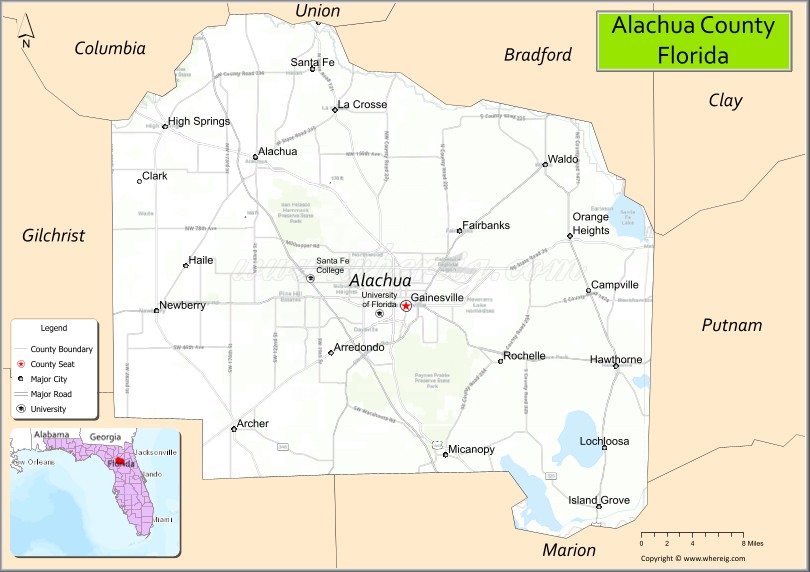
About Alachua County Map, Florida: The map showing the county boundary, county seat, major cities, highways, water bodies and neighbouring counties.
Most Viewed Links
About Alachua County, Florida
Alachua County is located in the north-central part of Florida, in the state of the United States. The county was established in 1824 and was named from a Native American term believed to describe a large sinkhole or prairie in the region. The county seat and largest city is Gainesville. Alachua County is widely recognized as an educational and cultural center, anchored by major institutions and a diverse local economy.
Population
According to the United States Census Bureau, the population of Alachua County is 278,468 as recorded in the 2020 Census, and the population density is approximately 318 people per square mile.
Area and Geography
According to the United States Census Bureau, Alachua County covers a total area of approximately 969 square miles (about 2,509 square kilometers), including about 875 square miles (2,266 square kilometers) of land and 94 square miles (243 square kilometers) of water. The county features rolling hills, freshwater springs, lakes, and conservation lands, contributing to its scenic environment and strong outdoor recreation culture.
Bordering Counties
Alachua County shares boundaries with Columbia County to the north, Union County to the northeast, Bradford County to the east, Putnam County to the southeast, Marion County to the south, Levy County to the southwest, and Gilchrist County to the west.
Major Cities and Communities
Major cities and towns include Gainesville, Alachua, High Springs, Newberry, Hawthorne, and Archer.
Attractions and Recreation
Alachua County offers numerous parks, springs, and natural areas, including Paynes Prairie Preserve State Park and several freshwater springs popular for swimming and kayaking. Cultural attractions, museums, and collegiate sporting events in Gainesville contribute to the county’s vibrant community life.
Transportation
Alachua County is served by Interstate 75, U.S. Highway 441, and several state roads that provide regional access throughout North Florida. Gainesville Regional Airport supports commercial and general aviation services.
Explore more counties in Florida Counties or view the complete USA States Map section for additional geographic information.
Sources:
Population and area data sourced from the United States Census Bureau (2020 Census). General county information referenced from the
| Country | United States |
| State | Florida |
| Region | North Central Florida |
| County Seat | Gainesville |
| Named After | Alachua Prairie (from Timucua and Spanish origins) |
| Established | 1824 |
| Organized | 1824 |
| Coordinates | 29.6740° N, 82.3570° W |
| Total Area | 875 sq mi |
| Land Area | 832 sq mi |
| Water Area | 43 sq mi |
| Population (2020) | 278,468 |
| Population Rank | Mid-to-large county in Florida |
| Major City | Gainesville |
| Main Industries | Education, Healthcare, Biotechnology, Government, Agriculture |
| Major Airport | Gainesville Regional Airport (GNV) |
| Time Zone | Eastern Time (UTC−05:00) |
| Known For | University of Florida, Paynes Prairie Preserve State Park, Springs and wetlands |
| Website | https://www.alachuacounty.us |