Map of Wakulla County - Wakulla County is a county located in the U.S. state of Florida. Wakulla County Map showing cities, highways, important places and water bodies. Get Where is Wakulla County located in the map, major cities in Wakulla county, population, areas, and places of interest.
Map of Wakulla County, Florida
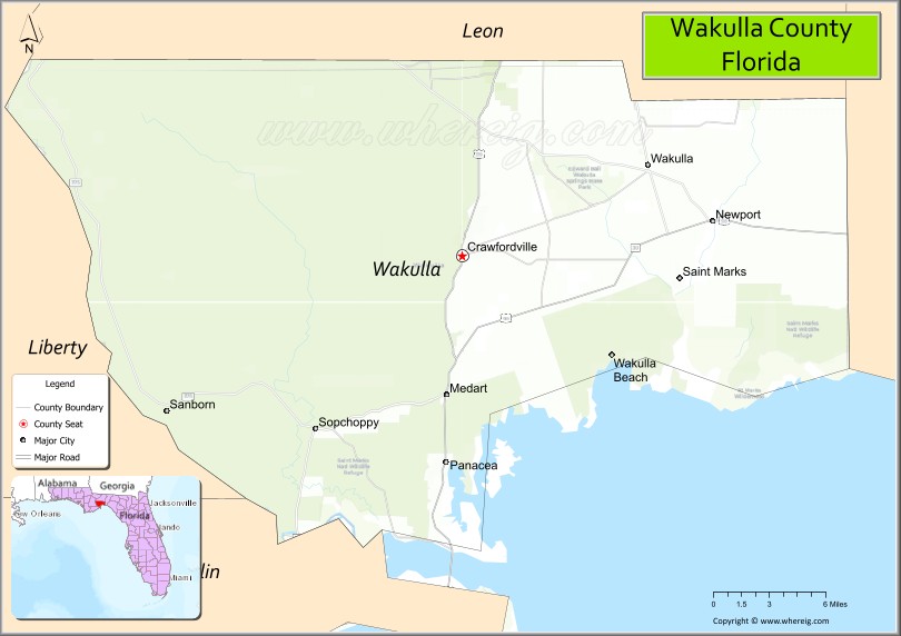
About Wakulla County Map, Florida: The map showing the county boundary, county seat, major cities, highways, water bodies and neighbouring counties.
Most Viewed Links
About Wakulla County, Florida
Wakulla County is located in the northwestern part of Florida, in the state of the United States. The county was established in 1843 and was named after a Native American term believed to describe local springs or water features. The county seat and largest community is Crawfordville. Wakulla County is known for its natural springs, coastal marshes, and largely undeveloped landscapes in Florida’s Big Bend region.
Population
According to the United States Census Bureau, the population of Wakulla County is 33,739 as recorded in the 2020 Census, and the population density is approximately 46 people per square mile.
Area and Geography
According to the United States Census Bureau, Wakulla County covers a total area of approximately 736 square miles (about 1,907 square kilometers), including about 606 square miles (1,570 square kilometers) of land and 130 square miles (337 square kilometers) of water. The county features Gulf Coast shoreline, extensive wetlands, forested areas, and prominent freshwater springs such as Wakulla Springs.
Bordering Counties
Wakulla County shares boundaries with Jefferson County to the east, Leon County to the north, and Franklin County to the west.
Major Cities and Communities
Major cities and towns include Crawfordville, St. Marks, Sopchoppy, and Panacea.
Attractions and Recreation
Wakulla County offers outdoor recreation centered around Wakulla Springs State Park, coastal marshlands, and the Gulf of Mexico. Activities include boating, fishing, hiking, and wildlife observation in preserved natural areas. Tallahassee Community College serves residents in the surrounding region and supports higher education access nearby.
Transportation
Wakulla County is served by U.S. Highway 319 and State Road 98, providing connectivity to Tallahassee and coastal communities along the Gulf. These routes support local travel and regional access within the Florida Panhandle.
Explore more counties in Florida Counties or view the complete USA States Map section for additional geographic information.
Sources:
Population and area data sourced from the United States Census Bureau (2020 Census). General county information referenced from the Official Wakulla County Government Website.
Facts about Wakulla County, Florida
| Country | United States |
| State | Florida |
| Region | North Florida (Big Bend) |
| County Seat | Crawfordville |
| Named After | Wakulla Springs / Native American origin |
| Established | 1843 |
| Organized | 1843 |
| Coordinates | 30.1722° N, 84.3758° W |
| Total Area | 735 sq mi |
| Land Area | 607 sq mi |
| Water Area | 128 sq mi |
| Population (2020) | 33,739 |
| Population Rank | Small to mid-sized county in North Florida |
| Major City | Crawfordville |
| Main Industries | Government, Tourism, Forestry, Public Services |
| Major Airport | Tallahassee International Airport (nearby) |
| Time Zone | Eastern Time (UTC−05:00) |
| Known For | Wakulla Springs, coastal marshes, natural scenery |
| Website | https://www.wakullacountyfl.gov |
Ctities in Wakulla county
| City Name | Type | Population (2020) | Pop. Density | Area | Incorporated |
|---|---|---|---|---|---|
| Bay Minette | City | 8,107 | 946.0/sq mi (365.2/km2) | 8.57 sq mi (22.2 km2) | |
| Daphne | City | 27,462 | 1,691.0/sq mi (652.9/km2) | 16.24 sq mi (42.1 km2) | |
| Elberta | Town | 1,974 | 292.0/sq mi (112.7/km2) | 6.76 sq mi (17.5 km2) | |
| Fairhope | City | 22,477 | 1,863.8/sq mi (719.6/km2) | 12.06 sq mi (31.2 km2) | |
| Foley | City | 20,335 | 789.1/sq mi (304.7/km2) | 25.77 sq mi (66.7 km2) | |
| Gulf Shores | City | 15,014 | 648.3/sq mi (250.3/km2) | 23.16 sq mi (60 km2) | |
| Loxley | Town | 3,710 | 116.5/sq mi (45.0/km2) | 31.85 sq mi (82.5 km2) | |
| Magnolia Springs | Town | 811 | 901.1/sq mi (347.9/km2) | 0.9 sq mi (2.3 km2) | |
| Orange Beach | City | 8,095 | 550.7/sq mi (212.6/km2) | 14.7 sq mi (38.1 km2) | |
| Perdido Beach | Town | 555 | 447.6/sq mi (172.8/km2) | 1.24 sq mi (3.2 km2) | |
| Robertsdale | City | 6,708 | 1,230.8/sq mi (475.2/km2) | 5.45 sq mi (14.1 km2) | |
| Silverhill | Town | 768 | 640.0/sq mi (247.1/km2) | 1.2 sq mi (3.1 km2) | |
| Spanish Fort | City | 10,049 | 350.0/sq mi (135.1/km2) | 28.71 sq mi (74.4 km2) | |
| Summerdale | Town | 1,468 | 151.5/sq mi (58.5/km2) | 9.69 sq mi (25.1 km2) |
Top Attractions in Wakulla County, Florida
- Wakulla Springs State Park – Clear springs and boat tours.
- Edward Ball Wakulla Springs – Historic lodge and wildlife.
- St. Marks National Wildlife Refuge – Birdwatching and lighthouse.
- St. Marks Lighthouse – Coastal views and history.
- Downtown Crawfordville – Shops and small-town charm.
- San Marcos de Apalache Historic State Park – Historic fort site.
- Ochlockonee Bay – Fishing and scenic views.
- Shell Point Beach – Quiet Gulf Coast beach.
- Scenic Coastal Drives – Marshlands and Gulf vistas.
- Local Nature Trails – Walking and wildlife viewing.
Highways in Wakulla
Interstate highways, State Road 267, State Road 363, County Road 375, U.S. Route 319..
Nearest Airports
Nearest airport of Wakulla is Wakulla County Airport.
- Alachua County Map
- Baker County Map
- Bay County Map
- Bradford County Map
- Brevard County Map
- Broward County Map
- Calhoun County Map
- Charlotte County Map
- Citrus County Map
- Clay County Map
- Collier County Map
- Columbia County Map
- DeSoto County Map
- Dixie County Map
- Duval County Map
- Escambia County Map
- Flagler County Map
- Franklin County Map
- Gadsden County Map
- Gilchrist County Map
- Glades County Map
- Gulf County Map
- Hamilton County Map
- Hardee County Map
- Hendry County Map
- Hernando County Map
- Highlands County Map
- Hillsborough County Map
- Holmes County Map
- Indian River County Map
- Jackson County Map
- Jefferson County Map
- Lafayette County Map
- Lake County Map
- Lee County Map
- Leon County Map
- Levy County Map
- Liberty County Map
- Madison County Map
- Manatee County Map
- Marion County Map
- Martin County Map
- Miami-Dade County Map
- Monroe County Map
- Nassau County Map
- Okaloosa County Map
- Okeechobee County Map
- Orange County Map
- Osceola County Map
- Palm Beach County Map
- Pasco County Map
- Pinellas County Map
- Polk County Map
- Putnam County Map
- St Johns County Map
- St Lucie County Map
- Santa Rosa County Map
- Sarasota County Map
- Seminole County Map
- Sumter County Map
- Suwannee County Map
- Taylor County Map
- Union County Map
- Volusia County Map
- Wakulla County Map
- Walton County Map
- Washington County Map
- Where is Miami
- Where is Hialeah
- Where is Jacksonville
- Where is Orlando
- Where is Saint Petersburg
- Where is Tampa
- Where is Alafaya
- Where is Boca Raton
- Where is Boynton Beach
- Where is Brandon
- Where is Cape Coral
- Where is Clearwater
- Where is Coral Springs
- Where is Davie
- Where is Daytona Beach
- Where is Deerfield Beach
- Where is Deltona
- Where is Doral
- Where is Fort Lauderdale
- Where is Fort Myers
- Where is Gainesville
- Where is Hollywood
- Where is Homestead
- Where is Horizon West
- Where is Kendall
- Where is Kissimmee
- Where is Lakeland
- Where is Largo
- Where is Lauderhill
- Where is Lehigh Acres
- Where is Melbourne
- Where is Miami Beach
- Where is Miami Gardens
- Where is Miramar
- Where is North Port
- Where is Palm Bay
- Where is Palm Coast
- Where is Pembroke Pines
- Where is Plantation
- Where is Poinciana
- Where is Pompano Beach
- Where is Port St. Lucie
- Where is Riverview
- Where is Spring Hill
- Where is St. Petersburg
- Where is Sunrise
- Where is Tallahassee
- Where is Tamarac
- Where is The Villages
- Where is Town 'n' Country
- Where is West Palm Beach