Map of Franklin County - Franklin County is a county located in the U.S. state of Florida. Franklin County Map showing cities, highways, important places and water bodies. Get Where is Franklin County located in the map, major cities in Franklin county, population, areas, and places of interest.
Map of Franklin County, Florida
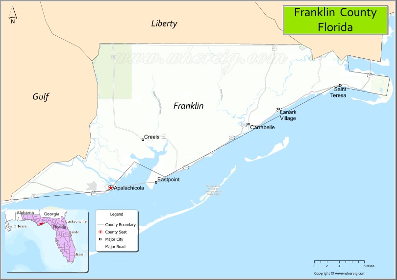
About Franklin County Map, Florida: The map showing the county boundary, county seat, major cities, highways, water bodies and neighbouring counties.
Most Viewed Links
About Franklin County, Florida
Franklin County is located in the northwestern part of Florida, in the state of the United States. The county was established in 1832 and was named after Benjamin Franklin, one of the Founding Fathers of the United States. The county seat is Apalachicola, and the largest community is Eastpoint. Franklin County is known for its Gulf Coast shoreline, fishing industry, and preserved natural landscapes in the Florida Panhandle.
Population
According to the United States Census Bureau, the population of Franklin County is 12,451 as recorded in the 2020 Census, and the population density is approximately 24 people per square mile.
Area and Geography
According to the United States Census Bureau, Franklin County covers a total area of approximately 1,026 square miles (about 2,658 square kilometers), including about 535 square miles (1,386 square kilometers) of land and 491 square miles (1,272 square kilometers) of water. The county features extensive Gulf of Mexico coastline, barrier islands such as St. George Island, and estuaries that support commercial and recreational fishing.
Bordering Counties
Franklin County shares boundaries with Liberty County to the north, Wakulla County to the east, and Gulf County to the west.
Major Cities and Communities
Major cities and towns include Apalachicola, Carrabelle, Eastpoint, and St. George Island.
Attractions and Recreation
Franklin County offers outdoor recreation centered around its coastal waters, including boating, fishing, kayaking, and beach activities. The area is also known for the Apalachicola National Estuarine Research Reserve and historic districts in Apalachicola that reflect its maritime heritage.
Transportation
Franklin County is served by U.S. Highway 98, which runs along the Gulf Coast and connects communities across the Florida Panhandle. State roads provide access to inland areas and neighboring counties.
Explore more counties in Florida Counties or view the complete USA States Map section for additional geographic information.
Sources:
Population and area data sourced from the United States Census Bureau (2020 Census). General county information referenced from the Official Franklin County Government Website.
Facts about Franklin County, Florida
| Country | United States |
| State | Florida |
| Region | Florida Panhandle (Forgotten Coast) |
| County Seat | Apalachicola |
| Named After | Benjamin Franklin |
| Established | 1832 |
| Organized | 1832 |
| Coordinates | 29.8110° N, 84.8150° W |
| Total Area | 1,037 sq mi |
| Land Area | 545 sq mi |
| Water Area | 492 sq mi |
| Population (2020) | 12,451 |
| Population Rank | Small, coastal county in the Florida Panhandle |
| Major City | Apalachicola |
| Main Industries | Seafood, Fishing, Tourism, Forestry |
| Major Airport | Apalachicola Regional Airport |
| Time Zone | Eastern Time (UTC−05:00) |
| Known For | Apalachicola Bay oysters, Forgotten Coast, historic waterfront |
| Website | https://www.franklincountyflorida.com |
Ctities in Franklin county
| City Name | Type | Population (2020) | Pop. Density | Area | Incorporated |
|---|---|---|---|---|---|
| Apalachicola | City | 2,341 | 2.7 sq mi (7.0 km2) | 1831 | |
| Carrabelle | City | 2,606 | 4.8 sq mi (12.5 km2) | 1893 | |
| Hodges | Town | 265 | 64.0/sq mi (24.7/km2) | 4.14 sq mi (10.7 km2) | |
| Phil Campbell | Town | 992 | 243.7/sq mi (94.1/km2) | 4.07 sq mi (10.5 km2) | |
| Red Bay | City | 3,232 | 331.8/sq mi (128.1/km2) | 9.74 sq mi (25.2 km2) | |
| Russellville | City | 10,855 | 810.1/sq mi (312.8/km2) | 13.4 sq mi (34.7 km2) | |
| Vina | Town | 325 | 67.7/sq mi (26.1/km2) | 4.8 sq mi (12.4 km2) |
Top Attractions in Franklin County, Florida
- Apalachicola Historic District – Shops, dining, and maritime charm.
- St. George Island State Park – Pristine beaches and dunes.
- Apalachicola National Estuarine Research Reserve – Wetlands and wildlife.
- John Gorrie Museum State Park – Ice-making history exhibits.
- Apalachicola Maritime Museum – Boatbuilding and maritime history.
- Carrabelle Beach – Quiet Gulf beach access.
- Camp Gordon Johnston WWII Museum – Military history displays.
- St. George Island Lighthouse – Coastal views and history.
- Apalachicola Riverfront – Scenic waterfront walks.
- Scenic Coastal Drives – Gulf and bay views.
Highways in Franklin
CR 30 , CR 30A, CR 65, CR 67, CR 67A , CR 300 , CR 370, CR 370 , CR 376.
Nearest Airports
Nearest airport of Franklin are Apalachicola Regional Airport, Carrabelle-Thompson Airport, St. George Island Airport.
- Alachua County Map
- Baker County Map
- Bay County Map
- Bradford County Map
- Brevard County Map
- Broward County Map
- Calhoun County Map
- Charlotte County Map
- Citrus County Map
- Clay County Map
- Collier County Map
- Columbia County Map
- DeSoto County Map
- Dixie County Map
- Duval County Map
- Escambia County Map
- Flagler County Map
- Franklin County Map
- Gadsden County Map
- Gilchrist County Map
- Glades County Map
- Gulf County Map
- Hamilton County Map
- Hardee County Map
- Hendry County Map
- Hernando County Map
- Highlands County Map
- Hillsborough County Map
- Holmes County Map
- Indian River County Map
- Jackson County Map
- Jefferson County Map
- Lafayette County Map
- Lake County Map
- Lee County Map
- Leon County Map
- Levy County Map
- Liberty County Map
- Madison County Map
- Manatee County Map
- Marion County Map
- Martin County Map
- Miami-Dade County Map
- Monroe County Map
- Nassau County Map
- Okaloosa County Map
- Okeechobee County Map
- Orange County Map
- Osceola County Map
- Palm Beach County Map
- Pasco County Map
- Pinellas County Map
- Polk County Map
- Putnam County Map
- St Johns County Map
- St Lucie County Map
- Santa Rosa County Map
- Sarasota County Map
- Seminole County Map
- Sumter County Map
- Suwannee County Map
- Taylor County Map
- Union County Map
- Volusia County Map
- Wakulla County Map
- Walton County Map
- Washington County Map
- Where is Miami
- Where is Hialeah
- Where is Jacksonville
- Where is Orlando
- Where is Saint Petersburg
- Where is Tampa
- Where is Alafaya
- Where is Boca Raton
- Where is Boynton Beach
- Where is Brandon
- Where is Cape Coral
- Where is Clearwater
- Where is Coral Springs
- Where is Davie
- Where is Daytona Beach
- Where is Deerfield Beach
- Where is Deltona
- Where is Doral
- Where is Fort Lauderdale
- Where is Fort Myers
- Where is Gainesville
- Where is Hollywood
- Where is Homestead
- Where is Horizon West
- Where is Kendall
- Where is Kissimmee
- Where is Lakeland
- Where is Largo
- Where is Lauderhill
- Where is Lehigh Acres
- Where is Melbourne
- Where is Miami Beach
- Where is Miami Gardens
- Where is Miramar
- Where is North Port
- Where is Palm Bay
- Where is Palm Coast
- Where is Pembroke Pines
- Where is Plantation
- Where is Poinciana
- Where is Pompano Beach
- Where is Port St. Lucie
- Where is Riverview
- Where is Spring Hill
- Where is St. Petersburg
- Where is Sunrise
- Where is Tallahassee
- Where is Tamarac
- Where is The Villages
- Where is Town 'n' Country
- Where is West Palm Beach