Map of Walton County - Walton County is a county located in the U.S. state of Florida. Walton County Map showing cities, highways, important places and water bodies. Get Where is Walton County located in the map, major cities in Walton county, population, areas, and places of interest.
Map of Walton County, Florida
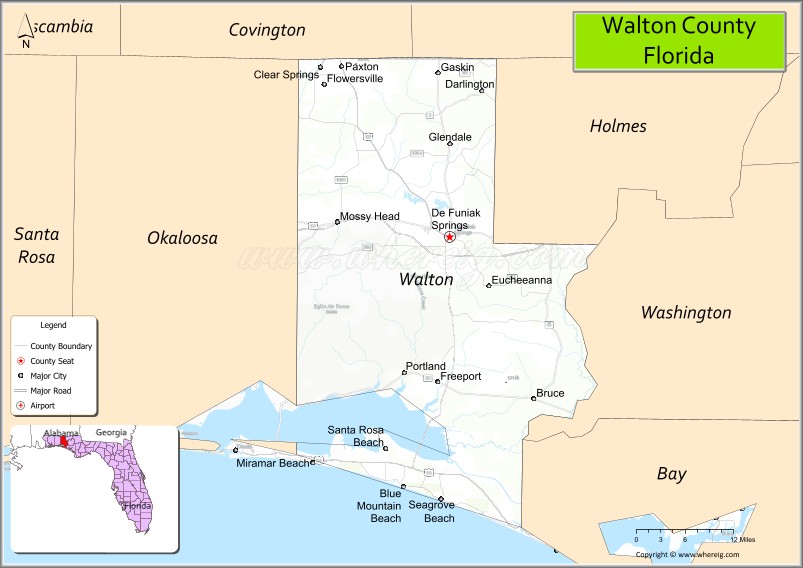
About Walton County Map, Florida: The map showing the county boundary, county seat, major cities, highways, water bodies and neighbouring counties.
Most Viewed Links
About Walton County, Florida
Walton County is located in the northwestern part of Florida, in the state of the United States. The county was established in 1824 and was named after Colonel George Walton Jr., a secretary of the Florida Territory. The county seat is DeFuniak Springs, and the largest community is Miramar Beach. Walton County is part of the Florida Panhandle and is known for its scenic Gulf Coast beaches and growing residential and tourism sectors.
Population
According to the United States Census Bureau, the population of Walton County is 75,305 as recorded in the 2020 Census, and the population density is approximately 71 people per square mile.
Area and Geography
According to the United States Census Bureau, Walton County covers a total area of approximately 1,143 square miles (about 2,960 square kilometers), including about 1,038 square miles (2,689 square kilometers) of land and 105 square miles (272 square kilometers) of water. The county features Gulf of Mexico coastline, rare coastal dune lakes, inland forests, and rural communities.
Bordering Counties
Walton County shares boundaries with Holmes County to the north, Washington County to the northeast, Bay County to the east, Okaloosa County to the west, and the Gulf of Mexico to the south.
Major Cities and Communities
Major cities and towns include DeFuniak Springs, Miramar Beach, Santa Rosa Beach, Freeport, and Paxton.
Attractions and Recreation
Walton County is widely recognized for its beaches along the Emerald Coast, including areas along Scenic Highway 30A. Outdoor recreation includes boating, fishing, beach activities, and exploration of coastal dune lakes and state parks. Northwest Florida State College serves residents in the surrounding region and supports higher education access nearby.
Transportation
Walton County is served by U.S. Highway 98 along the coast and U.S. Highway 331, which provides north-south access through the county. Interstate 10 runs across the northern portion, linking the county to regional transportation networks in the Florida Panhandle.
Explore more counties in Florida Counties or view the complete USA States Map section for additional geographic information.
Sources:
Population and area data sourced from the United States Census Bureau (2020 Census). General county information referenced from the Official Walton County Government Website.
Facts about Walton County, Florida
| Country | United States |
| State | Florida |
| Region | Florida Panhandle (Emerald Coast) |
| County Seat | DeFuniak Springs |
| Named After | Colonel George Walton |
| Established | 1824 |
| Organized | 1824 |
| Coordinates | 30.6180° N, 86.1710° W |
| Total Area | 1,240 sq mi |
| Land Area | 1,038 sq mi |
| Water Area | 202 sq mi |
| Population (2020) | 75,305 |
| Population Rank | Fast-growing coastal county in the Florida Panhandle |
| Major City | Santa Rosa Beach |
| Main Industries | Tourism, Real Estate, Construction, Retail |
| Major Airport | Northwest Florida Beaches International Airport (nearby) |
| Time Zone | Central Time (UTC−06:00) |
| Known For | Scenic Highway 30A, sugar-white beaches, coastal dune lakes |
| Website | https://www.co.walton.fl.us |
Ctities in Walton county
| City Name | Type | Population (2020) | Pop. Density | Area | Incorporated |
|---|---|---|---|---|---|
| DeFuniak Springs | City | 5,919 | 11.3 sq mi (29.1 km2) | 1901 | |
| Freeport | City | 5,861 | 10.8 sq mi (28.0 km2) | 1963 | |
| Paxton | Town | 556 | 4.0 sq mi (10.3 km2) | 1952 |
Top Attractions in Walton County, Florida
- Seaside – Iconic planned beach town.
- Grayton Beach State Park – Dunes, trails, and beaches.
- 30A Scenic Highway – Coastal towns and views.
- Santa Rosa Beach – White sand beaches.
- Western Lake – Rare coastal dune lake.
- Rosemary Beach – Walkable town and architecture.
- Eden Gardens State Park – Historic mansion and gardens.
- Point Washington State Forest – Hiking and wildlife.
- DeFuniak Springs Lake Yard – Circular spring-fed lake.
- Scenic Coastal Drives – Gulf views and dune landscapes.
Highways in Walton
Interstate 10, US Highway 90, US Highway 98, US Highway 331, Florida State Road 20, Florida State Road 30A, Florida State Road 81, Florida State Road 83.
Nearest Airports
Nearest airport of Walton is DeFuniak Springs Airport.
- Alachua County Map
- Baker County Map
- Bay County Map
- Bradford County Map
- Brevard County Map
- Broward County Map
- Calhoun County Map
- Charlotte County Map
- Citrus County Map
- Clay County Map
- Collier County Map
- Columbia County Map
- DeSoto County Map
- Dixie County Map
- Duval County Map
- Escambia County Map
- Flagler County Map
- Franklin County Map
- Gadsden County Map
- Gilchrist County Map
- Glades County Map
- Gulf County Map
- Hamilton County Map
- Hardee County Map
- Hendry County Map
- Hernando County Map
- Highlands County Map
- Hillsborough County Map
- Holmes County Map
- Indian River County Map
- Jackson County Map
- Jefferson County Map
- Lafayette County Map
- Lake County Map
- Lee County Map
- Leon County Map
- Levy County Map
- Liberty County Map
- Madison County Map
- Manatee County Map
- Marion County Map
- Martin County Map
- Miami-Dade County Map
- Monroe County Map
- Nassau County Map
- Okaloosa County Map
- Okeechobee County Map
- Orange County Map
- Osceola County Map
- Palm Beach County Map
- Pasco County Map
- Pinellas County Map
- Polk County Map
- Putnam County Map
- St Johns County Map
- St Lucie County Map
- Santa Rosa County Map
- Sarasota County Map
- Seminole County Map
- Sumter County Map
- Suwannee County Map
- Taylor County Map
- Union County Map
- Volusia County Map
- Wakulla County Map
- Walton County Map
- Washington County Map
- Where is Miami
- Where is Hialeah
- Where is Jacksonville
- Where is Orlando
- Where is Saint Petersburg
- Where is Tampa
- Where is Alafaya
- Where is Boca Raton
- Where is Boynton Beach
- Where is Brandon
- Where is Cape Coral
- Where is Clearwater
- Where is Coral Springs
- Where is Davie
- Where is Daytona Beach
- Where is Deerfield Beach
- Where is Deltona
- Where is Doral
- Where is Fort Lauderdale
- Where is Fort Myers
- Where is Gainesville
- Where is Hollywood
- Where is Homestead
- Where is Horizon West
- Where is Kendall
- Where is Kissimmee
- Where is Lakeland
- Where is Largo
- Where is Lauderhill
- Where is Lehigh Acres
- Where is Melbourne
- Where is Miami Beach
- Where is Miami Gardens
- Where is Miramar
- Where is North Port
- Where is Palm Bay
- Where is Palm Coast
- Where is Pembroke Pines
- Where is Plantation
- Where is Poinciana
- Where is Pompano Beach
- Where is Port St. Lucie
- Where is Riverview
- Where is Spring Hill
- Where is St. Petersburg
- Where is Sunrise
- Where is Tallahassee
- Where is Tamarac
- Where is The Villages
- Where is Town 'n' Country
- Where is West Palm Beach