Map of Miami-Dade County - Miami-Dade County is a county located in the U.S. state of Florida. It's county seat is Miami. Miami-Dade County Map showing cities, highways, important places and water bodies.
Miami-Dade County Map, Florida

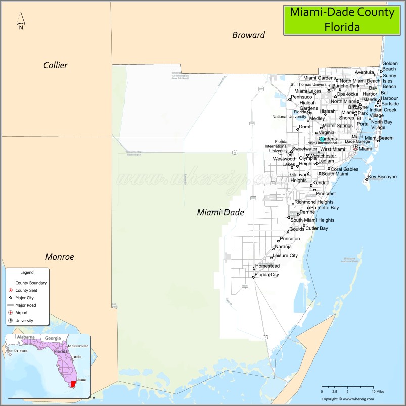
About Miami-Dade County Map, Florida: The map showing the county boundary, county seat, major cities, highways, water bodies and neighbouring counties.
Most Viewed Links
About Miami-Dade County, Florida
Miami-Dade County is a county located in the southeastern part of the state of Florida, along the Atlantic coast. The county is the most populous in Florida and is home to the city of Miami, which is its county seat. Miami-Dade County is known for its beautiful beaches, diverse population, and cultural attractions.
As per 2020 census, the population of Miami-Dade County is 2662777 people and population density is 1368.33 square miles. According to the United States Census Bureau, the county has a total area of 1,946 sq mi (5,040 km2). Miami-Dade County was established on 1836.
Miami-Dade County is a major hub for international trade and commerce, with a thriving economy that includes industries such as finance, healthcare, tourism, and technology. The county is also home to several colleges and universities, including Florida International University and the University of Miami.
Miami-Dade County has many parks and natural areas, including the Everglades National Park and the Biscayne National Park. The county has a tropical climate, with hot and humid summers and mild winters.
Miami-Dade County government is led by a mayor and a board of county commissioners and provides services such as law enforcement, public transportation, and emergency management. Some popular attractions in Miami-Dade County include South Beach, the Art Deco Historic District, the Vizcaya Museum and Gardens, and the Miami Seaquarium. The county is also home to several professional sports teams, including the Miami Heat, Miami Dolphins, and Miami Marlins.
Miami-Dade County Facts
Ctities in Miami-Dade county
City Name | Type | Population (2020) | Pop. Density | Area | Incorporated |
---|---|---|---|---|---|
Aventura | City | 40,242 | 3.5 sq mi (9.1 km2) | 1995 | |
Bal Harbour | Village | 3,093 | 0.6 sq mi (1.6 km2) | 1946 | |
Bay Harbor Islands | Town | 5,922 | 0.6 sq mi (1.6 km2) | 1947 | |
Biscayne Park | Village | 3,117 | 0.6 sq mi (1.7 km2) | 1933 | |
Coral Gables | City | 49,248 | 37.2 sq mi (96.2 km2) | 1925 | |
Cutler Bay | Town | 45,425 | 4.9 sq mi (12.6 km2) | 2005 | |
Doral | City | 75,874 | 13.6 sq mi (35.3 km2) | 2003 | |
El Portal | Village | 1,986 | 0.4 sq mi (1.1 km2) | 1937 | |
Florida City | City | 13,085 | 3.2 sq mi (18.3 km2) | 1914 | |
Golden Beach | Town | 961 | 0.3 sq mi (1.0 km2) | 1929 | |
Hialeah | City | 223,109 | 19.7 sq mi (51.5 km2) | 1925 | |
Hialeah Gardens | City | 23,068 | 2.5 sq mi (6.5 km2) | 1948 | |
Homestead | City | 80,737 | 14.4 sq mi (37.2 km2) | 1913 | |
Indian Creek | Village | 84 | 0.4 sq mi (1.2 km2) | 1939 | |
Key Biscayne | Village | 14,809 | 1.4 sq mi (3.6 km2) | 1991 | |
Medley | Town | 1,056 | 4.3 sq mi (11.1 km2) | 1949 | |
Miami | City | 442,241 | 55.3 sq mi (143.3 km2) | 1896 | |
Miami Beach | City | 82,890 | 18.7 sq mi (48.5 km2) | 1915 | |
Miami Gardens | City | 111,640 | 20.0 sq mi (51.8 km2) | 2003 | |
Miami Lakes | Town | 30,467 | 6.4 sq mi (16.5 km2) | 2000 | |
Miami Shores | Village | 11,567 | 3.7 sq mi (9.7 km2) | 1932 | |
Miami Springs | City | 13,859 | 3.0 sq mi (7.7 km2) | 1926 | |
North Bay Village | City | 8,159 | 0.8 sq mi (2.2 km2) | 1945 | |
North Miami | City | 60,191 | 10.0 sq mi (25.9 km2) | 1926 | |
North Miami Beach | City | 43,676 | 5.0 sq mi (13.7 km2) | 1926 | |
Opa-locka | City | 16,463 | 4.5 sq mi (11.6 km2) | 1926 | |
Palmetto Bay | Village | 24,439 | 8.8 sq mi (22.6 km2) | 2002 | |
Pinecrest | Village | 18,388 | 7.6 sq mi (19.6 km2) | 1996 | |
South Miami | City | 12,026 | 2.3 sq mi (6.0 km2) | 1926 | |
Sunny Isles Beach | City | 22,342 | 1.4 sq mi (3.6 km2) | 1997 | |
Surfside | Town | 5,689 | 1.0 sq mi (2.5 km2) | 1935 | |
Sweetwater | City | 19,363 | 0.8 sq mi (2.1 km2) | 1941 | |
Virginia Gardens | Village | 2,364 | 0.3 sq mi (0.8 km2) | 1947 | |
West Miami | City | 7,233 | 0.7 sq mi (1.8 km2) | 1947 |
Places to Visit in Miami-Dade County
Top places to visit in Vizcaya Museum & Gardens, Zoo Miami, Bayside Marketplace, Bayfront Park, Miami-Dade Arena, Phillip & Patricia Frost Museum , Coral Castle, Crandon Park, Fairchild Tropical Botanic Garden, Deering Estate, Venetian Pool, Miami Children's Museum, Oleta River State Park, Dolphin Mall, Everglades National Park, Matheson Hammock Park, History Miami Museum, Haulover Park, Monkey Jungle, Historic Virginia Key Beach Park, South Pointe Park Pier, Tropical Park, Maurice A. Ferré Park, ZWF Miami, Everglades Alligator Farm, Cape Florida Lighthouse, The Kampong, National Tropical.
Highways in Miami-Dade
Interstate 95, U.S. Highway 1, U.S. Highway 98, I-75, I-95, I-195 / SR 112, I-395 / SR 836, US 1, US 27, US 41, US 441, SR A1A, SR 826, SR 874, SR 878, SR 924.
Nearest Airports
Nearest airport of Miami-Dade is Miami International Airport.
- Alachua County Map
- Baker County Map
- Bay County Map
- Bradford County Map
- Brevard County Map
- Broward County Map
- Calhoun County Map
- Charlotte County Map
- Citrus County Map
- Clay County Map
- Collier County Map
- Columbia County Map
- DeSoto County Map
- Dixie County Map
- Duval County Map
- Escambia County Map
- Flagler County Map
- Franklin County Map
- Gadsden County Map
- Gilchrist County Map
- Glades County Map
- Gulf County Map
- Hamilton County Map
- Hardee County Map
- Hendry County Map
- Hernando County Map
- Highlands County Map
- Hillsborough County Map
- Holmes County Map
- Indian River County Map
- Jackson County Map
- Jefferson County Map
- Lafayette County Map
- Lake County Map
- Lee County Map
- Leon County Map
- Levy County Map
- Liberty County Map
- Madison County Map
- Manatee County Map
- Marion County Map
- Martin County Map
- Miami-Dade County Map
- Monroe County Map
- Nassau County Map
- Okaloosa County Map
- Okeechobee County Map
- Orange County Map
- Osceola County Map
- Palm Beach County Map
- Pasco County Map
- Pinellas County Map
- Polk County Map
- Putnam County Map
- St Johns County Map
- St Lucie County Map
- Santa Rosa County Map
- Sarasota County Map
- Seminole County Map
- Sumter County Map
- Suwannee County Map
- Taylor County Map
- Union County Map
- Volusia County Map
- Wakulla County Map
- Walton County Map
- Washington County Map
- Alabama Counties
- Alaska boroughs
- Arizona Counties
- Arkansas Counties
- California County Map
- Colorado Counties
- Connecticut Counties
- Delaware Counties
- Florida County Map
- Georgia County Map
- Hawaii Counties
- Idaho Counties
- Illinois Counties
- Indiana Counties
- Iowa Counties
- Kansas Counties
- Kentucky Counties
- Louisiana Counties
- Maine Counties
- Maryland Counties
- Massachusetts Counties
- Michigan County Map
- Minnesota Counties
- Mississippi Counties
- Missouri Counties
- Montana Counties
- Nebraska Counties
- New Hampshire Counties
- New Jersey Counties
- New Mexico Counties
- North Carolina Counties
- North Dakota Counties
- Oklahoma Counties
- Oregon Counties
- Pennsylvania Counties
- Rhode Island Counties
- South Carolina Counties
- South Dakota Counties
- Map of Tennessee
- Texas County Map
- Utah Counties
- Vermont Counties
- Virginia Counties
- Washington Counties
- West Virginia Counties
- Wisconsin Counties
- Wyoming Counties
- Nevada Counties
- New York Counties
- Ohio County Map