Map of Osceola County - Osceola County is a county located in the U.S. state of Florida. Osceola County Map showing cities, highways, important places and water bodies. Get Where is Osceola County located in the map, major cities in Osceola county, population, areas, and places of interest.
Map of Osceola County, Florida
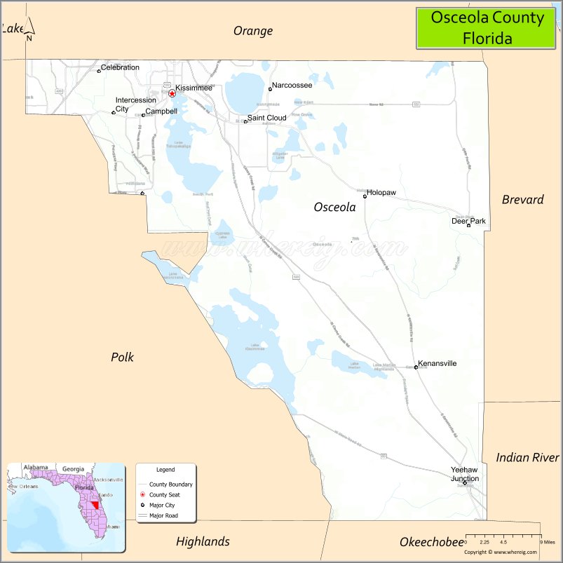
About Osceola County Map, Florida: The map showing the county boundary, county seat, major cities, highways, water bodies and neighbouring counties.
Most Viewed Links
About Osceola County, Florida
Osceola County is located in the central part of Florida, in the state of the United States. The county was established in 1887 and was named after Osceola, a leader of the Seminole people during the Second Seminole War. The county seat is Kissimmee, which is also the largest city. Osceola County is part of the Orlando metropolitan area and is known for tourism, agriculture, and rapidly growing residential communities.
Population
According to the United States Census Bureau, the population of Osceola County is 388,656 as recorded in the 2020 Census, and the population density is approximately 292 people per square mile.
Area and Geography
According to the United States Census Bureau, Osceola County covers a total area of approximately 1,506 square miles (about 3,900 square kilometers), including about 1,322 square miles (3,424 square kilometers) of land and 184 square miles (476 square kilometers) of water. The county features lakes, wetlands, cattle ranches, and portions of the Kissimmee River basin.
Bordering Counties
Osceola County shares boundaries with Orange County to the north, Brevard County to the east, Indian River County to the southeast, Okeechobee County to the south, Highlands County to the southwest, and Polk County to the west.
Major Cities and Communities
Major cities and towns include Kissimmee, St. Cloud, Celebration, Poinciana, and Buenaventura Lakes.
Attractions and Recreation
Osceola County offers outdoor recreation including boating and fishing along Lake Tohopekaliga and the Kissimmee Chain of Lakes. The county also supports tourism activities connected to nearby theme parks and entertainment districts. Valencia College and the University of Central Florida have campuses serving residents in the region, contributing to higher education and workforce development.
Transportation
Osceola County is served by Florida’s Turnpike, U.S. Highway 192, and State Road 417, providing regional connectivity across Central Florida. SunRail commuter rail and nearby Orlando International Airport enhance transportation access.
Explore more counties in Florida Counties or view the complete USA States Map section for additional geographic information.
Sources:
Population and area data sourced from the United States Census Bureau (2020 Census). General county information referenced from the Official Osceola County Government Website.
Facts about Osceola County, Florida
| Country | United States |
| State | Florida |
| Region | Central Florida |
| County Seat | Kissimmee |
| Named After | Osceola (Seminole leader) |
| Established | 1887 |
| Organized | 1887 |
| Coordinates | 28.0597° N, 81.1431° W |
| Total Area | 1,506 sq mi |
| Land Area | 1,327 sq mi |
| Water Area | 179 sq mi |
| Population (2020) | 388,656 |
| Population Rank | Fast-growing county in Central Florida |
| Major City | Kissimmee |
| Main Industries | Tourism, Hospitality, Construction, Retail |
| Major Airport | Orlando International Airport (nearby) |
| Time Zone | Eastern Time (UTC−05:00) |
| Known For | Theme park corridor, resort communities, Kissimmee River |
| Website | https://www.osceola.org |
Ctities in Osceola county
| City Name | Type | Population (2020) | Pop. Density | Area | Incorporated |
|---|---|---|---|---|---|
| Kissimmee | City | 79,226 | 17.3 sq mi (44.8 km2) | 1883 | |
| St. Cloud | City | 58,964 | 9.2 sq mi (23.7 km2) | 1911 |
Top Attractions in Osceola County, Florida
- Walt Disney World (nearby access) – Theme parks and resorts.
- Old Town Kissimmee – Shops, dining, and car shows.
- Gatorland – Alligators and wildlife shows.
- Kissimmee Lakefront Park – Trails and lake views.
- Osceola County Courthouse – Historic courthouse landmark.
- Shingle Creek Regional Park – Kayaking and nature trails.
- Osceola County Welcome Center – Local travel information.
- Medieval Times Dinner & Tournament – Themed dining entertainment.
- Disney Springs (nearby) – Shopping and dining district.
- Scenic Wetland Drives – Natural Florida landscapes.
Highways in Osceola
State Road 417, g State Road 429, Osceola County 522, US 441, US 17/92, US 192, CR 15, SR 60.
Nearest Airports
Nearest airport of Osceola is Kissimmee Gateway Airport.
- Alachua County Map
- Baker County Map
- Bay County Map
- Bradford County Map
- Brevard County Map
- Broward County Map
- Calhoun County Map
- Charlotte County Map
- Citrus County Map
- Clay County Map
- Collier County Map
- Columbia County Map
- DeSoto County Map
- Dixie County Map
- Duval County Map
- Escambia County Map
- Flagler County Map
- Franklin County Map
- Gadsden County Map
- Gilchrist County Map
- Glades County Map
- Gulf County Map
- Hamilton County Map
- Hardee County Map
- Hendry County Map
- Hernando County Map
- Highlands County Map
- Hillsborough County Map
- Holmes County Map
- Indian River County Map
- Jackson County Map
- Jefferson County Map
- Lafayette County Map
- Lake County Map
- Lee County Map
- Leon County Map
- Levy County Map
- Liberty County Map
- Madison County Map
- Manatee County Map
- Marion County Map
- Martin County Map
- Miami-Dade County Map
- Monroe County Map
- Nassau County Map
- Okaloosa County Map
- Okeechobee County Map
- Orange County Map
- Osceola County Map
- Palm Beach County Map
- Pasco County Map
- Pinellas County Map
- Polk County Map
- Putnam County Map
- St Johns County Map
- St Lucie County Map
- Santa Rosa County Map
- Sarasota County Map
- Seminole County Map
- Sumter County Map
- Suwannee County Map
- Taylor County Map
- Union County Map
- Volusia County Map
- Wakulla County Map
- Walton County Map
- Washington County Map
- Where is Miami
- Where is Hialeah
- Where is Jacksonville
- Where is Orlando
- Where is Saint Petersburg
- Where is Tampa
- Where is Alafaya
- Where is Boca Raton
- Where is Boynton Beach
- Where is Brandon
- Where is Cape Coral
- Where is Clearwater
- Where is Coral Springs
- Where is Davie
- Where is Daytona Beach
- Where is Deerfield Beach
- Where is Deltona
- Where is Doral
- Where is Fort Lauderdale
- Where is Fort Myers
- Where is Gainesville
- Where is Hollywood
- Where is Homestead
- Where is Horizon West
- Where is Kendall
- Where is Kissimmee
- Where is Lakeland
- Where is Largo
- Where is Lauderhill
- Where is Lehigh Acres
- Where is Melbourne
- Where is Miami Beach
- Where is Miami Gardens
- Where is Miramar
- Where is North Port
- Where is Palm Bay
- Where is Palm Coast
- Where is Pembroke Pines
- Where is Plantation
- Where is Poinciana
- Where is Pompano Beach
- Where is Port St. Lucie
- Where is Riverview
- Where is Spring Hill
- Where is St. Petersburg
- Where is Sunrise
- Where is Tallahassee
- Where is Tamarac
- Where is The Villages
- Where is Town 'n' Country
- Where is West Palm Beach