Map of Sumter County - Sumter County is a county located in the U.S. state of Florida. Sumter County Map showing cities, highways, important places and water bodies. Get Where is Sumter County located in the map, major cities in Sumter county, population, areas, and places of interest.
Map of Sumter County, Florida
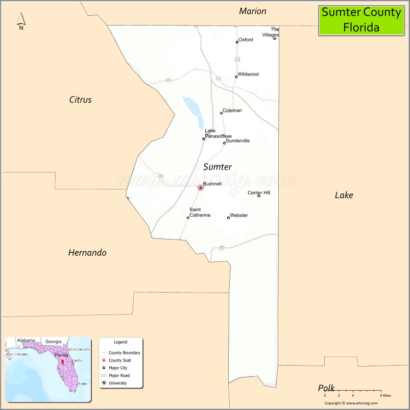
About Sumter County Map, Florida: The map showing the county boundary, county seat, major cities, highways, water bodies and neighbouring counties.
Most Viewed Links
About Sumter County, Florida
Sumter County is located in the central part of Florida, in the state of the United States. The county was established in 1853 and was named after General Thomas Sumter, a hero of the American Revolutionary War. The county seat is Bushnell, and the largest community is The Villages. Sumter County is known for its rural landscapes, agricultural heritage, and significant retirement communities.
Population
According to the United States Census Bureau, the population of Sumter County is 129,752 as recorded in the 2020 Census, and the population density is approximately 237 people per square mile.
Area and Geography
According to the United States Census Bureau, Sumter County covers a total area of approximately 580 square miles (about 1,502 square kilometers), including about 547 square miles (1,417 square kilometers) of land and 33 square miles (85 square kilometers) of water. The county features gently rolling terrain, pastureland, lakes, and expanding residential developments in central Florida.
Bordering Counties
Sumter County shares boundaries with Lake County to the east, Polk County to the south, Pasco County to the southwest, Hernando County to the west, Citrus County to the northwest, and Marion County to the north.
Major Cities and Communities
Major cities and towns include Bushnell, Wildwood, Webster, Center Hill, and The Villages.
Attractions and Recreation
Sumter County offers outdoor recreation opportunities including parks, lakes, and trails that support boating, fishing, and hiking. The Villages provides golf courses, entertainment venues, and community activities that attract retirees from across the country. Lake-Sumter State College serves residents by offering higher education programs and workforce training.
Transportation
Sumter County is served by Interstate 75 and Florida’s Turnpike, making it a key transportation corridor in central Florida. U.S. Highway 301 and State Road 44 provide additional regional connectivity.
Explore more counties in Florida Counties or view the complete USA States Map section for additional geographic information.
Sources:
Population and area data sourced from the United States Census Bureau (2020 Census). General county information referenced from the Official Sumter County Government Website.
Facts about Sumter County, Florida
| Country | United States |
| State | Florida |
| Region | Central Florida |
| County Seat | Bushnell |
| Named After | General Thomas Sumter |
| Established | 1853 |
| Organized | 1853 |
| Coordinates | 28.7142° N, 82.0710° W |
| Total Area | 580 sq mi |
| Land Area | 547 sq mi |
| Water Area | 33 sq mi |
| Population (2020) | 132,420 |
| Population Rank | Fast-growing county in Central Florida |
| Major City | The Villages (partially) |
| Main Industries | Healthcare, Retirement Services, Agriculture, Retail |
| Major Airport | Leesburg International Airport (nearby) |
| Time Zone | Eastern Time (UTC−05:00) |
| Known For | The Villages retirement community, rural landscapes |
| Website | https://www.sumtercountyfl.gov |
Ctities in Sumter county
| City Name | Type | Population (2020) | Pop. Density | Area | Incorporated |
|---|---|---|---|---|---|
| Bushnell | City | 3,047 | 2.4 sq mi (6.1 km2) | 1911 | |
| Center Hill | City | 846 | 1.8 sq mi (4.5 km2) | 1925 | |
| Coleman | City | 642 | 1.5 sq mi (3.8 km2) | 1908 | |
| Webster | City | 778 | 1.3 sq mi (3.4 km2) | 1900 | |
| Wildwood | City | 15,730 | 5.2 sq mi (13.4 km2) | 1877 | |
| Cuba | Town | 306 | 75.4/sq mi (29.1/km2) | 4.06 sq mi (10.5 km2) | |
| Emelle | Town | 32 | 152.4/sq mi (58.8/km2) | 0.21 sq mi (0.54 km2) | |
| Epes | Town | 272 | 141.7/sq mi (54.7/km2) | 1.92 sq mi (5 km2) | |
| Gainesville | Town | 172 | 100.0/sq mi (38.6/km2) | 1.72 sq mi (4.5 km2) | |
| Geiger | Town | 155 | 163.2/sq mi (63.0/km2) | 0.95 sq mi (2.5 km2) | |
| Livingston | City | 3,436 | 481.9/sq mi (186.1/km2) | 7.13 sq mi (18.5 km2) | |
| York | City | 2,414 | 351.4/sq mi (135.7/km2) | 6.87 sq mi (17.8 km2) |
Top Attractions in Sumter County, Florida
- The Villages Town Squares – Shopping, dining, and nightly music.
- Lake Panasoffkee – Fishing, boating, and nature views.
- Dade Battlefield Historic State Park – Seminole War history.
- Downtown Bushnell – Small-town charm and shops.
- Sumter County Courthouse – Historic courthouse landmark.
- Withlacoochee State Forest – Hiking and wildlife viewing.
- Withlacoochee State Trail – Biking and walking path.
- Lake Okahumpka Park – Boardwalks and birdwatching.
- Paige Pond Observation Area – Wildlife viewing platform.
- Scenic Rural Drives – Rolling pasture and woodland views.
Highways in Sumter
Interstate 75, U.S. Route 301, State Road 44, County Road 48, State Road 50, State Road 471.
Nearest Airports
Nearest airport of Sumter is Orlando International Airport (MCO / KMCO).
- Alachua County Map
- Baker County Map
- Bay County Map
- Bradford County Map
- Brevard County Map
- Broward County Map
- Calhoun County Map
- Charlotte County Map
- Citrus County Map
- Clay County Map
- Collier County Map
- Columbia County Map
- DeSoto County Map
- Dixie County Map
- Duval County Map
- Escambia County Map
- Flagler County Map
- Franklin County Map
- Gadsden County Map
- Gilchrist County Map
- Glades County Map
- Gulf County Map
- Hamilton County Map
- Hardee County Map
- Hendry County Map
- Hernando County Map
- Highlands County Map
- Hillsborough County Map
- Holmes County Map
- Indian River County Map
- Jackson County Map
- Jefferson County Map
- Lafayette County Map
- Lake County Map
- Lee County Map
- Leon County Map
- Levy County Map
- Liberty County Map
- Madison County Map
- Manatee County Map
- Marion County Map
- Martin County Map
- Miami-Dade County Map
- Monroe County Map
- Nassau County Map
- Okaloosa County Map
- Okeechobee County Map
- Orange County Map
- Osceola County Map
- Palm Beach County Map
- Pasco County Map
- Pinellas County Map
- Polk County Map
- Putnam County Map
- St Johns County Map
- St Lucie County Map
- Santa Rosa County Map
- Sarasota County Map
- Seminole County Map
- Sumter County Map
- Suwannee County Map
- Taylor County Map
- Union County Map
- Volusia County Map
- Wakulla County Map
- Walton County Map
- Washington County Map
- Where is Miami
- Where is Hialeah
- Where is Jacksonville
- Where is Orlando
- Where is Saint Petersburg
- Where is Tampa
- Where is Alafaya
- Where is Boca Raton
- Where is Boynton Beach
- Where is Brandon
- Where is Cape Coral
- Where is Clearwater
- Where is Coral Springs
- Where is Davie
- Where is Daytona Beach
- Where is Deerfield Beach
- Where is Deltona
- Where is Doral
- Where is Fort Lauderdale
- Where is Fort Myers
- Where is Gainesville
- Where is Hollywood
- Where is Homestead
- Where is Horizon West
- Where is Kendall
- Where is Kissimmee
- Where is Lakeland
- Where is Largo
- Where is Lauderhill
- Where is Lehigh Acres
- Where is Melbourne
- Where is Miami Beach
- Where is Miami Gardens
- Where is Miramar
- Where is North Port
- Where is Palm Bay
- Where is Palm Coast
- Where is Pembroke Pines
- Where is Plantation
- Where is Poinciana
- Where is Pompano Beach
- Where is Port St. Lucie
- Where is Riverview
- Where is Spring Hill
- Where is St. Petersburg
- Where is Sunrise
- Where is Tallahassee
- Where is Tamarac
- Where is The Villages
- Where is Town 'n' Country
- Where is West Palm Beach