Map of Marion County - Marion County is a county located in the U.S. state of Florida. Marion County Map showing cities, highways, important places and water bodies. Get Where is Marion County located in the map, major cities in Marion county, population, areas, and places of interest.
Map of Marion County, Florida
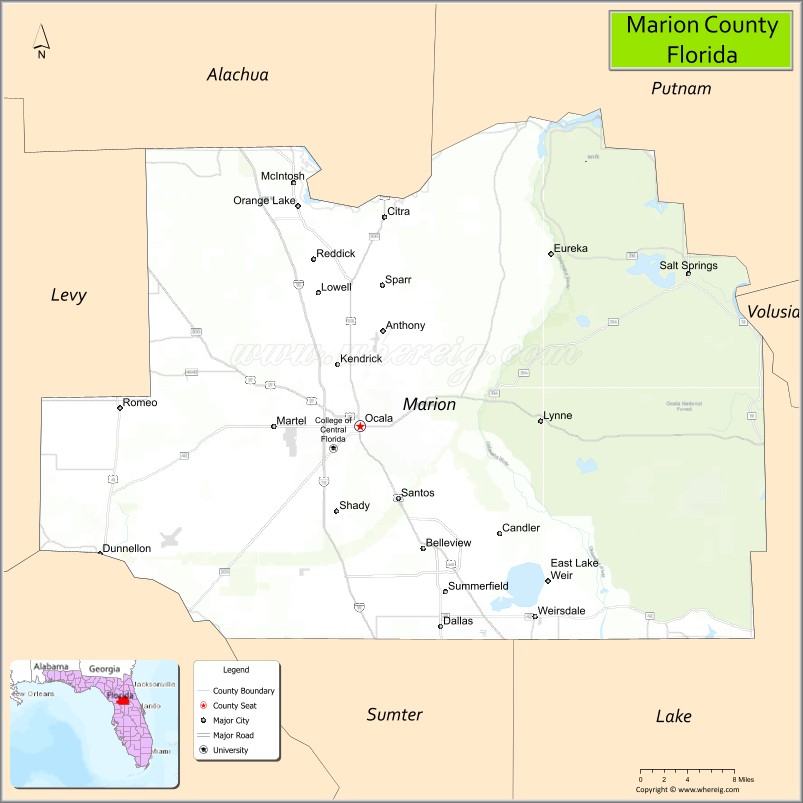
About Marion County Map, Florida: The map showing the county boundary, county seat, major cities, highways, water bodies and neighbouring counties.
Most Viewed Links
About Marion County, Florida
Marion County is located in the north-central part of Florida, in the state of the United States. The county was established in 1844 and was named after General Francis Marion, a hero of the American Revolutionary War. The county seat and largest city is Ocala. Marion County is known for its rolling hills, horse farms, and natural springs, earning Ocala the title of the “Horse Capital of the World.”
Population
According to the United States Census Bureau, the population of Marion County is 375,908 as recorded in the 2020 Census, and the population density is approximately 238 people per square mile.
Area and Geography
According to the United States Census Bureau, Marion County covers a total area of approximately 1,663 square miles (about 4,306 square kilometers), including about 1,585 square miles (4,105 square kilometers) of land and 78 square miles (202 square kilometers) of water. The county features gently rolling terrain, extensive forests, freshwater springs, and numerous lakes that distinguish it from many other parts of Florida.
Bordering Counties
Marion County shares boundaries with Alachua County to the north, Putnam County to the northeast, Lake County to the southeast, Sumter County to the south, Citrus County to the southwest, Levy County to the west, and Gilchrist County to the northwest.
Major Cities and Communities
Major cities and towns include Ocala, Belleview, Dunnellon, McIntosh, and Silver Springs Shores.
Attractions and Recreation
Marion County offers outdoor recreation at Silver Springs State Park and along the Ocala National Forest, including hiking, boating, and wildlife observation. The county’s equestrian industry and horse farms are central to its identity and economy. The College of Central Florida provides higher education opportunities and supports workforce development in the region.
Transportation
Marion County is served by Interstate 75, which runs north-south through Ocala, and U.S. Highway 27 and U.S. Highway 301, providing regional connectivity across central Florida.
Explore more counties in Florida Counties or view the complete USA States Map section for additional geographic information.
Sources:
Population and area data sourced from the United States Census Bureau (2020 Census). General county information referenced from the Official Marion County Government Website.
Facts about Marion County, Florida
| Country | United States |
| State | Florida |
| Region | North Central Florida |
| County Seat | Ocala |
| Named After | Francis Marion |
| Established | 1844 |
| Organized | 1844 |
| Coordinates | 29.2108° N, 82.0569° W |
| Total Area | 1,663 sq mi |
| Land Area | 1,585 sq mi |
| Water Area | 78 sq mi |
| Population (2020) | 375,908 |
| Population Rank | One of the largest counties in Florida by land area |
| Major City | Ocala |
| Main Industries | Agriculture, Equine Industry, Healthcare, Manufacturing |
| Major Airport | Ocala International Airport |
| Time Zone | Eastern Time (UTC−05:00) |
| Known For | Horse farms, Ocala National Forest, natural springs |
| Website | https://www.marionfl.org |
Ctities in Marion county
| City Name | Type | Population (2020) | Pop. Density | Area | Incorporated |
|---|---|---|---|---|---|
| Glen Allen | Town | 433 | 66.1/sq mi (25.5/km2) | 6.55 sq mi (17 km2) | |
| Belleview | City | 5,413 | 1.8 sq mi (4.7 km2) | 1885 | |
| Dunnellon | City | 1,928 | 7.4 sq mi (19.3 km2) | 1891 | |
| McIntosh | Town | 463 | 0.7 sq mi (1.8 km2) | 1913 | |
| Ocala | City | 63,591 | 38.6 sq mi (100.1 km2) | 1869 | |
| Reddick | Town | 449 | 1.2 sq mi (3.2 km2) | 1925 | |
| Bear Creek | Town | 1,047 | 76.8/sq mi (29.7/km2) | 13.63 sq mi (35.3 km2) | |
| Brilliant | Town | 845 | 79.0/sq mi (30.5/km2) | 10.69 sq mi (27.7 km2) | |
| Guin | City | 2,195 | 146.7/sq mi (56.7/km2) | 14.96 sq mi (38.7 km2) | |
| Hackleburg | Town | 1,425 | 93.3/sq mi (36.0/km2) | 15.27 sq mi (39.5 km2) | |
| Hamilton | City | 7,042 | 185.0/sq mi (71.4/km2) | 38.06 sq mi (98.6 km2) | |
| Twin | Town | 359 | 106.5/sq mi (41.1/km2) | 3.37 sq mi (8.7 km2) | |
| Gu-Win | Town | 141 | 72.7/sq mi (28.1/km2) | 1.94 sq mi (5 km2) | |
| Winfield | City | 4,845 | 280.4/sq mi (108.3/km2) | 17.28 sq mi (44.8 km2) | |
| Haleyville | City | 4,361 | 526.1/sq mi (203.1/km2) | 8.29 sq mi (21.5 km2) |
Top Attractions in Marion County, Florida
- Silver Springs State Park – Glass-bottom boats and springs.
- Ocala National Forest – Hiking, springs, and wildlife.
- Downtown Ocala Historic District – Shops and historic charm.
- Appleton Museum of Art – Art collections and exhibitions.
- Don Garlits Museum of Drag Racing – Motorsports history.
- Juniper Springs Recreation Area – Swimming and nature trails.
- Sholom Park – Peaceful gardens and walking paths.
- Florida Horse Park – Equestrian events and trails.
- Ocala Downtown Square – Dining and cultural events.
- Scenic Horse Country Drives – Rolling pastures and farms.
Highways in Marion
I-75, US41, US301, US441, SR19, SR25, SR35, SR40, SR200, SR326, SR464,SR492.
Nearest Airports
Nearest airport of Marion are Dunnellon/Marion County Airport, Ocala International Airport.
- Alachua County Map
- Baker County Map
- Bay County Map
- Bradford County Map
- Brevard County Map
- Broward County Map
- Calhoun County Map
- Charlotte County Map
- Citrus County Map
- Clay County Map
- Collier County Map
- Columbia County Map
- DeSoto County Map
- Dixie County Map
- Duval County Map
- Escambia County Map
- Flagler County Map
- Franklin County Map
- Gadsden County Map
- Gilchrist County Map
- Glades County Map
- Gulf County Map
- Hamilton County Map
- Hardee County Map
- Hendry County Map
- Hernando County Map
- Highlands County Map
- Hillsborough County Map
- Holmes County Map
- Indian River County Map
- Jackson County Map
- Jefferson County Map
- Lafayette County Map
- Lake County Map
- Lee County Map
- Leon County Map
- Levy County Map
- Liberty County Map
- Madison County Map
- Manatee County Map
- Marion County Map
- Martin County Map
- Miami-Dade County Map
- Monroe County Map
- Nassau County Map
- Okaloosa County Map
- Okeechobee County Map
- Orange County Map
- Osceola County Map
- Palm Beach County Map
- Pasco County Map
- Pinellas County Map
- Polk County Map
- Putnam County Map
- St Johns County Map
- St Lucie County Map
- Santa Rosa County Map
- Sarasota County Map
- Seminole County Map
- Sumter County Map
- Suwannee County Map
- Taylor County Map
- Union County Map
- Volusia County Map
- Wakulla County Map
- Walton County Map
- Washington County Map
- Where is Miami
- Where is Hialeah
- Where is Jacksonville
- Where is Orlando
- Where is Saint Petersburg
- Where is Tampa
- Where is Alafaya
- Where is Boca Raton
- Where is Boynton Beach
- Where is Brandon
- Where is Cape Coral
- Where is Clearwater
- Where is Coral Springs
- Where is Davie
- Where is Daytona Beach
- Where is Deerfield Beach
- Where is Deltona
- Where is Doral
- Where is Fort Lauderdale
- Where is Fort Myers
- Where is Gainesville
- Where is Hollywood
- Where is Homestead
- Where is Horizon West
- Where is Kendall
- Where is Kissimmee
- Where is Lakeland
- Where is Largo
- Where is Lauderhill
- Where is Lehigh Acres
- Where is Melbourne
- Where is Miami Beach
- Where is Miami Gardens
- Where is Miramar
- Where is North Port
- Where is Palm Bay
- Where is Palm Coast
- Where is Pembroke Pines
- Where is Plantation
- Where is Poinciana
- Where is Pompano Beach
- Where is Port St. Lucie
- Where is Riverview
- Where is Spring Hill
- Where is St. Petersburg
- Where is Sunrise
- Where is Tallahassee
- Where is Tamarac
- Where is The Villages
- Where is Town 'n' Country
- Where is West Palm Beach