Map of Volusia County - Volusia County is a county located in the U.S. state of Florida. It's county seat is DeLand. Volusia County Map showing cities, highways, important places and water bodies.
Map of Volusia County, Florida
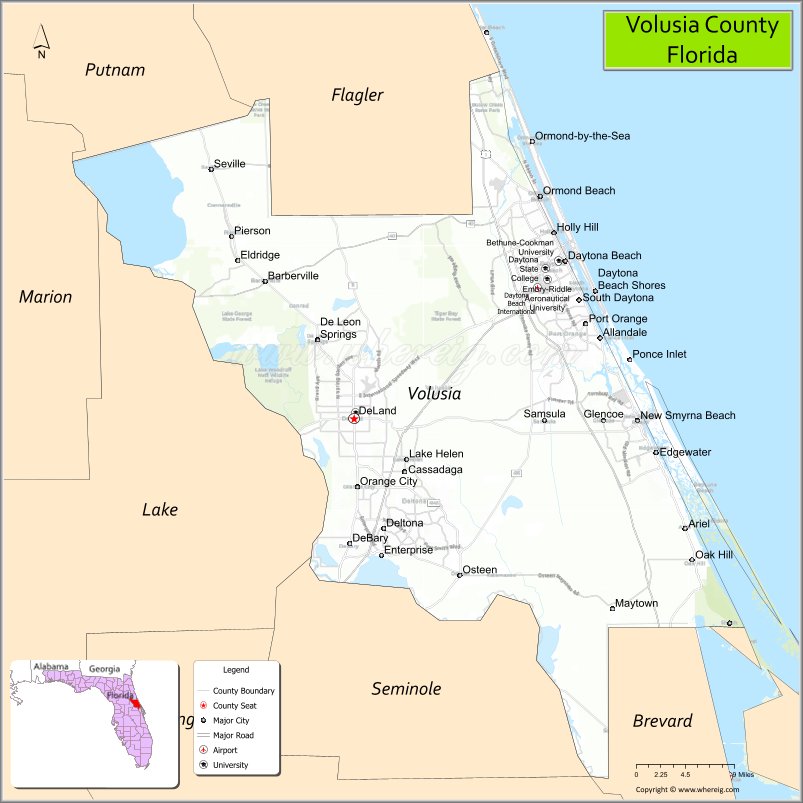
About Volusia County Map, Florida: The map showing the county boundary, county seat, major cities, highways, water bodies and neighbouring counties.
Most Viewed Links
About Volusia County, Florida
Volusia County is located in the east-central part of Florida, in the state of the United States. The county was established in 1854 and was named after the community of Volusia, an early settlement in the area. The county seat is DeLand, and the largest city is Deltona. Volusia County is part of the greater Orlando metropolitan region and is known for its Atlantic coastline, motorsports heritage, and diverse residential communities.
Population
According to the United States Census Bureau, the population of Volusia County is 553,543 as recorded in the 2020 Census, and the population density is approximately 502 people per square mile.
Area and Geography
According to the United States Census Bureau, Volusia County covers a total area of approximately 1,432 square miles (about 3,709 square kilometers), including about 1,101 square miles (2,851 square kilometers) of land and 331 square miles (858 square kilometers) of water. The county features Atlantic Ocean beaches, barrier islands, the Halifax River, and inland lakes and forests.
Bordering Counties
Volusia County shares boundaries with Flagler County to the north, Putnam County to the west, Lake County to the southwest, Orange County to the south, Seminole County to the southwest, and Brevard County to the south.
Major Cities and Communities
Major cities and towns include Deltona, Daytona Beach, DeLand, Ormond Beach, Port Orange, and New Smyrna Beach.
Attractions and Recreation
Volusia County is widely recognized for Daytona Beach, the Daytona International Speedway, and its Atlantic coastline. Outdoor recreation includes beach activities, boating along the Halifax River, and parks throughout the county. The county is also home to Stetson University and Daytona State College, contributing to higher education and workforce development in the region.
Transportation
Volusia County is served by Interstate 95 and Interstate 4, providing major north-south and westbound connectivity. U.S. Highway 1 runs along the coast, and Daytona Beach International Airport supports commercial and general aviation services.
Explore more counties in Florida Counties or view the complete USA States Map section for additional geographic information.
Volusia County has a humid subtropical climate, with hot and humid summers and mild winters. The county government is led by a council of elected officials, and it provides services such as law enforcement, public transportation, and emergency management.
Some popular attractions in Volusia County include the Daytona International Speedway, the Ponce de Leon Inlet Lighthouse, and the Daytona Beach Boardwalk and Pier. The county also has several parks and nature preserves, including the Tomoka State Park and the Spruce Creek Preserve, which offer opportunities for outdoor recreation and wildlife viewing.
Sources:
Population and area data sourced from the United States Census Bureau (2020 Census). General county information referenced from the Official Volusia County Government Website.
Facts about Volusia County, Florida
| Country | United States |
| State | Florida |
| Region | Central East Florida |
| County Seat | DeLand |
| Named After | Volusia plantation / name of unclear origin |
| Established | 1854 |
| Organized | 1854 |
| Coordinates | 29.0284° N, 81.0750° W |
| Total Area | 1,432 sq mi |
| Land Area | 1,101 sq mi |
| Water Area | 331 sq mi |
| Population (2020) | 553,284 |
| Population Rank | One of the most populous counties in Central Florida |
| Major City | Daytona Beach |
| Main Industries | Tourism, Education, Healthcare, Manufacturing |
| Major Airport | Daytona Beach International Airport |
| Time Zone | Eastern Time (UTC−05:00) |
| Known For | Daytona International Speedway, Atlantic beaches, St. Johns River |
| Website | https://www.volusia.org |
Ctities in Volusia county
| City Name | Type | Population (2020) | Pop. Density | Area | Incorporated |
|---|---|---|---|---|---|
| Daytona Beach | City | 72,647 | 64.9 sq mi (168.2 km2) | 1876 | |
| Daytona Beach Shores | City | 5,179 | 0.9 sq mi (2.4 km2) | 1960 | |
| DeBary | City | 22,260 | 21.4 sq mi (55.5 km2) | 1993 | |
| DeLand | City | 37,351 | 16.1 sq mi (41.6 km2) | 1882 | |
| Deltona | City | 93,692 | 41.1 sq mi (106.4 km2) | 1995 | |
| Edgewater | City | 23,097 | 10.4 sq mi (26.8 km2) | 1924 | |
| Holly Hill | City | 12,958 | 4.5 sq mi (11.7 km2) | 1901 | |
| Lake Helen | City | 2,842 | 4.3 sq mi (11.2 km2) | 1888 | |
| New Smyrna Beach | City | 30,142 | 30.8 sq mi (79.7 km2) | 1887 | |
| Oak Hill | City | 1,986 | 11.3 sq mi (29.1 km2) | 1927 | |
| Orange City | City | 12,632 | 6.2 sq mi (15.9 km2) | 1882 | |
| Ormond Beach | City | 43,475 | 29.0 sq mi (75.3 km2) | 1880 | |
| Pierson | Town | 1,542 | 8.7 sq mi (22.7 km2) | 1926 | |
| Ponce Inlet | Town | 3,364 | 14.6 sq mi (38.0 km2) | 1963 | |
| Port Orange | City | 62,596 | 26.7 sq mi (69.1 km2) | 1867 | |
| South Daytona | City | 12,865 | 4.9 sq mi (12.5 km2) | 1938 |
Top Attractions in Volusia County, Florida
- Daytona Beach – Drive-on beach and boardwalk.
- Daytona International Speedway – Famous motorsports venue.
- Blue Spring State Park – Manatee viewing and springs.
- New Smyrna Beach – Surfing and coastal charm.
- Downtown DeLand Historic District – Shops and culture.
- Ponce de Leon Inlet Lighthouse – Scenic coastal views.
- Canaveral National Seashore (nearby) – Pristine beaches.
- Stetson University Campus – Historic university grounds.
- Marine Science Center – Sea turtle and wildlife exhibits.
- Scenic A1A Coastal Drive – Ocean and dune views.
Highways in Volusia
Interstate 95, Interstate 4, U.S. 1, US 17, US 92, SR A1A, SR 40, SR 44, SR 46, SR 5A, SR 5A, SR 421.
Nearest Airports
Nearest airport of Volusia are Daytona Beach International, DeLand Municipal Airport, Massey Ranch Airpark, New Smyrna Beach Municipal Airport, Ormond Beach Municipal Airport, Pierson Municipal Airport.
- Alachua County Map
- Baker County Map
- Bay County Map
- Bradford County Map
- Brevard County Map
- Broward County Map
- Calhoun County Map
- Charlotte County Map
- Citrus County Map
- Clay County Map
- Collier County Map
- Columbia County Map
- DeSoto County Map
- Dixie County Map
- Duval County Map
- Escambia County Map
- Flagler County Map
- Franklin County Map
- Gadsden County Map
- Gilchrist County Map
- Glades County Map
- Gulf County Map
- Hamilton County Map
- Hardee County Map
- Hendry County Map
- Hernando County Map
- Highlands County Map
- Hillsborough County Map
- Holmes County Map
- Indian River County Map
- Jackson County Map
- Jefferson County Map
- Lafayette County Map
- Lake County Map
- Lee County Map
- Leon County Map
- Levy County Map
- Liberty County Map
- Madison County Map
- Manatee County Map
- Marion County Map
- Martin County Map
- Miami-Dade County Map
- Monroe County Map
- Nassau County Map
- Okaloosa County Map
- Okeechobee County Map
- Orange County Map
- Osceola County Map
- Palm Beach County Map
- Pasco County Map
- Pinellas County Map
- Polk County Map
- Putnam County Map
- St Johns County Map
- St Lucie County Map
- Santa Rosa County Map
- Sarasota County Map
- Seminole County Map
- Sumter County Map
- Suwannee County Map
- Taylor County Map
- Union County Map
- Volusia County Map
- Wakulla County Map
- Walton County Map
- Washington County Map
- Where is Miami
- Where is Hialeah
- Where is Jacksonville
- Where is Orlando
- Where is Saint Petersburg
- Where is Tampa
- Where is Alafaya
- Where is Boca Raton
- Where is Boynton Beach
- Where is Brandon
- Where is Cape Coral
- Where is Clearwater
- Where is Coral Springs
- Where is Davie
- Where is Daytona Beach
- Where is Deerfield Beach
- Where is Deltona
- Where is Doral
- Where is Fort Lauderdale
- Where is Fort Myers
- Where is Gainesville
- Where is Hollywood
- Where is Homestead
- Where is Horizon West
- Where is Kendall
- Where is Kissimmee
- Where is Lakeland
- Where is Largo
- Where is Lauderhill
- Where is Lehigh Acres
- Where is Melbourne
- Where is Miami Beach
- Where is Miami Gardens
- Where is Miramar
- Where is North Port
- Where is Palm Bay
- Where is Palm Coast
- Where is Pembroke Pines
- Where is Plantation
- Where is Poinciana
- Where is Pompano Beach
- Where is Port St. Lucie
- Where is Riverview
- Where is Spring Hill
- Where is St. Petersburg
- Where is Sunrise
- Where is Tallahassee
- Where is Tamarac
- Where is The Villages
- Where is Town 'n' Country
- Where is West Palm Beach