Map of Flagler County - Flagler County is a county located in the U.S. state of Florida. Flagler County Map showing cities, highways, important places and water bodies. Get Where is Flagler County located in the map, major cities in Flagler county, population, areas, and places of interest.
Map of Flagler County, Florida
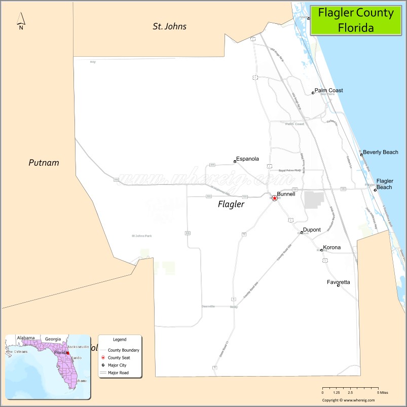
About Flagler County Map, Florida: The map showing the county boundary, county seat, major cities, highways, water bodies and neighbouring counties.
Most Viewed Links
About Flagler County, Florida
Flagler County is located in the northeastern part of Florida, in the state of the United States. The county was established in 1917 and was named after Henry Morrison Flagler, a railroad developer who played a major role in Florida’s east coast expansion. The county seat is Bunnell, and the largest city is Palm Coast. Flagler County is known for its Atlantic coastline, residential communities, and growing suburban development.
Population
According to the United States Census Bureau, the population of Flagler County was 115,378 as recorded in the 2020 Census.
Area and Geography
According to the United States Census Bureau, Flagler County covers a total area of approximately 571 square miles (about 1,479 square kilometers), including about 485 square miles (1,256 square kilometers) of land and 86 square miles (223 square kilometers) of water. The county features Atlantic Ocean beaches, the Intracoastal Waterway, marshlands, and inland residential areas, offering a mix of coastal and suburban landscapes.
Bordering Counties
Flagler County shares boundaries with St. Johns County to the north, Putnam County to the west, and Volusia County to the south.
Major Cities and Communities
Major cities and towns include Palm Coast, Bunnell, Flagler Beach, and Beverly Beach.
Attractions and Recreation
Flagler County offers coastal recreation along Flagler Beach and waterfront activities along the Intracoastal Waterway. Parks, golf courses, nature preserves, and scenic coastal routes contribute to the county’s appeal for residents and visitors seeking outdoor experiences.
Transportation
Flagler County is served by Interstate 95 and U.S. Highway 1, providing north-south connectivity along Florida’s east coast. State Road 100 connects inland and coastal communities, supporting regional transportation and economic activity.
Explore more counties in Florida Counties or view the complete USA States Map section for additional geographic information.
Sources:
Population and area data sourced from the United States Census Bureau (2020 Census). General county information referenced from the Official Flagler County Government Website.
<Facts about Flagler County, Florida
| Country | United States |
| State | Florida |
| Region | Northeast Florida |
| County Seat | Bunnell |
| Named After | Henry Morrison Flagler |
| Established | 1917 |
| Organized | 1917 |
| Coordinates | 29.4710° N, 81.2869° W |
| Total Area | 571 sq mi |
| Land Area | 485 sq mi |
| Water Area | 86 sq mi |
| Population (2020) | 115,081 |
| Population Rank | Small to mid-sized coastal county in Northeast Florida |
| Major City | Palm Coast |
| Main Industries | Tourism, Healthcare, Retail, Construction |
| Major Airport | Flagler Executive Airport |
| Time Zone | Eastern Time (UTC−05:00) |
| Known For | Palm Coast, Atlantic beaches, Intracoastal Waterway |
| Website | https://www.flaglercounty.gov |
Ctities in Flagler county
| City Name | Type | Population (2020) | Pop. Density | Area | Incorporated |
|---|---|---|---|---|---|
| Beverly Beach | Town | 474 | 0.4 sq mi (1.0 km2) | 1955 | |
| Bunnell | City | 3,276 | 4.7 sq mi (12.1 km2) | 1913 | |
| Flagler Beach | City | 5,160 | 4.1 sq mi (10.6 km2) | 1925 | |
| Palm Coast | City | 89,258 | 51.7 sq mi (133.9 km2) | 1999 | |
| Marineland | Town | 15 | 0.3 sq mi (0.8 km2) | 1940 |
Top Attractions in Flagler County, Florida
- Flagler Beach – Atlantic beaches and fishing pier.
- Bulow Creek State Park – Trails and historic sugar mill ruins.
- Gamble Rogers Memorial State Recreation Area – Beachfront camping.
- Downtown Palm Coast – Shops, dining, and local parks.
- Washington Oaks Gardens State Park – Formal gardens and coquina rocks.
- Bulow Plantation Ruins Historic State Park – Plantation ruins and nature.
- Flagler County Historical Society Museum – Local history exhibits.
- Wadsworth Park – Trails and picnic areas.
- Intracoastal Waterway Access – Kayaking and boating.
- Scenic A1A Coastal Drive – Ocean views and beaches.
Highways in Flagler
Interstate 95, U.S. 1, SR A1A, SR 11, SR 20, SR 100.
Nearest Airports
Nearest airport of Flagler is Flagler County Airport.
- Alachua County Map
- Baker County Map
- Bay County Map
- Bradford County Map
- Brevard County Map
- Broward County Map
- Calhoun County Map
- Charlotte County Map
- Citrus County Map
- Clay County Map
- Collier County Map
- Columbia County Map
- DeSoto County Map
- Dixie County Map
- Duval County Map
- Escambia County Map
- Flagler County Map
- Franklin County Map
- Gadsden County Map
- Gilchrist County Map
- Glades County Map
- Gulf County Map
- Hamilton County Map
- Hardee County Map
- Hendry County Map
- Hernando County Map
- Highlands County Map
- Hillsborough County Map
- Holmes County Map
- Indian River County Map
- Jackson County Map
- Jefferson County Map
- Lafayette County Map
- Lake County Map
- Lee County Map
- Leon County Map
- Levy County Map
- Liberty County Map
- Madison County Map
- Manatee County Map
- Marion County Map
- Martin County Map
- Miami-Dade County Map
- Monroe County Map
- Nassau County Map
- Okaloosa County Map
- Okeechobee County Map
- Orange County Map
- Osceola County Map
- Palm Beach County Map
- Pasco County Map
- Pinellas County Map
- Polk County Map
- Putnam County Map
- St Johns County Map
- St Lucie County Map
- Santa Rosa County Map
- Sarasota County Map
- Seminole County Map
- Sumter County Map
- Suwannee County Map
- Taylor County Map
- Union County Map
- Volusia County Map
- Wakulla County Map
- Walton County Map
- Washington County Map
- Where is Miami
- Where is Hialeah
- Where is Jacksonville
- Where is Orlando
- Where is Saint Petersburg
- Where is Tampa
- Where is Alafaya
- Where is Boca Raton
- Where is Boynton Beach
- Where is Brandon
- Where is Cape Coral
- Where is Clearwater
- Where is Coral Springs
- Where is Davie
- Where is Daytona Beach
- Where is Deerfield Beach
- Where is Deltona
- Where is Doral
- Where is Fort Lauderdale
- Where is Fort Myers
- Where is Gainesville
- Where is Hollywood
- Where is Homestead
- Where is Horizon West
- Where is Kendall
- Where is Kissimmee
- Where is Lakeland
- Where is Largo
- Where is Lauderhill
- Where is Lehigh Acres
- Where is Melbourne
- Where is Miami Beach
- Where is Miami Gardens
- Where is Miramar
- Where is North Port
- Where is Palm Bay
- Where is Palm Coast
- Where is Pembroke Pines
- Where is Plantation
- Where is Poinciana
- Where is Pompano Beach
- Where is Port St. Lucie
- Where is Riverview
- Where is Spring Hill
- Where is St. Petersburg
- Where is Sunrise
- Where is Tallahassee
- Where is Tamarac
- Where is The Villages
- Where is Town 'n' Country
- Where is West Palm Beach