Map of Brevard County - Brevard County is a county located in the U.S. state of Florida. Brevard County Map showing cities, highways, important places and water bodies. Get Where is Brevard County located in the map, major cities in Brevard county, population, areas, and places of interest.
Map of Brevard County, Florida
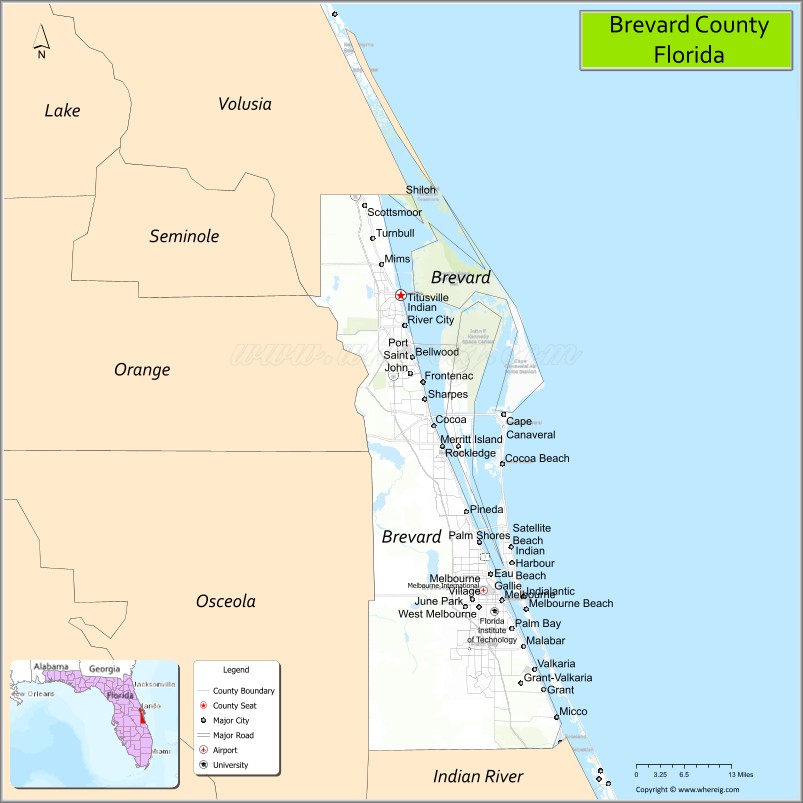
About Brevard County Map, Florida: The map showing the county boundary, county seat, major cities, highways, water bodies and neighbouring counties.
Most Viewed Links
About Brevard County, Florida
Brevard County is located in the east-central part of Florida, in the state of the United States. The county was established in 1855 and was named after Theodore Washington Brevard, a Florida state comptroller. The county seat is Titusville, and the largest city is Palm Bay. Brevard County is widely known as the “Space Coast” due to the presence of major aerospace facilities and its role in U.S. space exploration.
Population
According to the United States Census Bureau, the population of Brevard County is 606,612 as recorded in the 2020 Census, and the population density is approximately 608 people per square mile.
Area and Geography
According to the United States Census Bureau, Brevard County covers a total area of approximately 1,557 square miles (about 4,033 square kilometers), including about 1,016 square miles (2,632 square kilometers) of land and 541 square miles (1,401 square kilometers) of water. The county features Atlantic Ocean coastline, barrier islands, the Indian River Lagoon, and inland residential communities, making it one of Florida’s most geographically diverse coastal counties.
Bordering Counties
Brevard County shares boundaries with Volusia County to the north, Indian River County to the south, Osceola County to the southwest, and Orange County to the west.
Major Cities and Communities
Major cities and towns include Palm Bay, Melbourne, Titusville, Cocoa, Rockledge, Satellite Beach, and Cape Canaveral.
Attractions and Recreation
Brevard County is home to Kennedy Space Center and Cape Canaveral Space Force Station, attracting visitors interested in space exploration history. The county also offers Atlantic beaches, wildlife refuges, boating, fishing, and numerous parks along the Indian River Lagoon.
Transportation
Brevard County is served by Interstate 95, U.S. Highway 1, and State Road A1A, providing north-south coastal connectivity. Melbourne Orlando International Airport supports regional air travel, while Port Canaveral functions as a major cruise and cargo port.
Explore more counties in Florida Counties or view the complete USA States Map section for additional geographic information.
Sources:
Population and area data sourced from the United States Census Bureau (2020 Census). General county information referenced from the Official Bre
Facts about Brevard County, Florida
Country United States State Florida Region East Central Florida (Space Coast) County Seat Titusville Named After Judge Theodore W. Brevard Established 1844 Organized 1844 Coordinates 28.2639° N, 80.7214° W Total Area 1,557 sq mi Land Area 1,016 sq mi Water Area 541 sq mi Population (2020) 606,612 Population Rank One of the largest counties on Florida’s east coast Major City Palm Bay Main Industries Aerospace, Defense, Tourism, Technology, Manufacturing Major Airport Melbourne Orlando International Airport Time Zone Eastern Time (UTC−05:00) Known For Kennedy Space Center, Space Coast beaches, Rocket launches Website https://www.brevardfl.gov