Map of Collier County - Collier County is a county located in the U.S. state of Florida. It's county seat is East Naples. Collier County Map showing cities, highways, important places and water bodies.
Map of Collier County, Florida
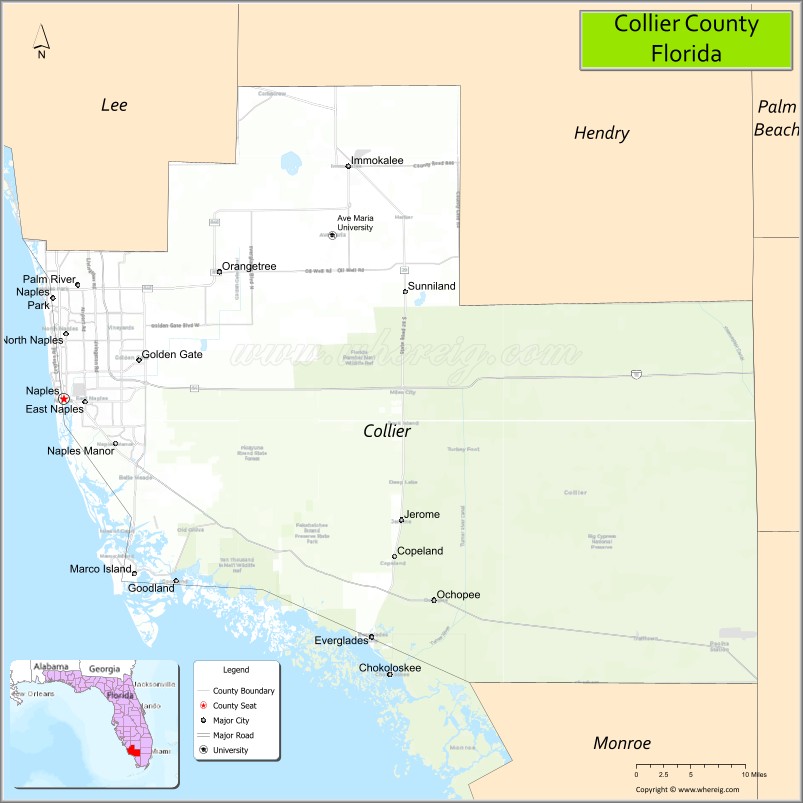
About Collier County Map, Florida: The map showing the county boundary, county seat, major cities, highways, water bodies and neighbouring counties.
Most Viewed Links
About Collier County, Florida
Collier County is located in the southwestern part of United States, within the state of Florida. The county was established in 1923 and was named after Barron Gift Collier, a businessman and developer who played a key role in promoting the region’s early growth. The county seat is East Naples, while the largest city is Naples. Known for its Gulf Coast shoreline, natural preserves, and growing residential communities, Collier County forms an important part of Southwest Florida’s economic and environmental landscape.
Collier County is known for its beautiful beaches, luxurious golf courses, and natural attractions such as the Everglades National Park and Big Cypress National Preserve. It is also home to several wildlife sanctuaries and state parks, including the Corkscrew Swamp Sanctuary and the Collier-Seminole State Park. The county is served by the Southwest Florida International Airport, which is located in neighboring Lee County.
Population
According to the United States Census Bureau, the population of Collier County was 375,752 as recorded in the 2020 Census.
Area and Geography
According to the United States Census Bureau, Collier County covers a total area of approximately 2,305 square miles (about 5,971 square kilometers), including about 1,998 square miles (5,175 square kilometers) of land and 307 square miles (796 square kilometers) of water. It is one of the largest counties in Florida by land area. The county features coastal beaches along the Gulf of Mexico, extensive wetlands, and portions of the Everglades ecosystem.
Bordering Counties
Collier County shares boundaries with Lee County to the north, Hendry County to the northeast, Broward County to the east, and Monroe County to the south.
Major Cities and Communities
The principal communities include Naples, Marco Island, Everglades City, Golden Gate, Immokalee, and North Naples.
Attractions and Recreation
Collier County is known for its natural attractions and outdoor recreation. Popular destinations include Everglades National Park, Big Cypress National Preserve, and the white-sand beaches along the Gulf Coast. The county also offers boating, fishing, wildlife viewing, golf courses, and cultural venues in Naples and surrounding communities.
Transportation
Transportation in Collier County is supported by Interstate 75 (Alligator Alley), U.S. Highway 41 (Tamiami Trail), and regional road networks connecting coastal and inland communities. Naples Airport serves general aviation, while nearby Southwest Florida International Airport provides commercial air service for the region.
Explore more counties in Florida Counties or view the complete USA States Map section for additional geographic information.
Sources:
Population and area data sourced from the United States Census Bureau (2020 Census). General county information referenced from the Official Collier County Government Website.
Facts about Collier County, Florida
| Country | United States |
| State | Florida |
| Region | Southwest Florida |
| County Seat | East Naples |
| Named After | Barron G. Collier |
| Established | 1923 |
| Organized | 1923 |
| Coordinates | 26.1189° N, 81.4086° W |
| Total Area | 2,305 sq mi |
| Land Area | 1,999 sq mi |
| Water Area | 306 sq mi |
| Population (2020) | 375,752 |
| Population Rank | One of the largest counties in Florida by area |
| Major City | Naples |
| Main Industries | Tourism, Real Estate, Agriculture, Healthcare |
| Major Airport | Naples Municipal Airport |
| Time Zone | Eastern Time (UTC−05:00) |
| Known For | Everglades, Gulf Coast beaches, upscale communities |
| Website | https://www.colliercountyfl.gov |
Ctities in Collier county
| City Name | Type | Population (2020) | Pop. Density | Area | Incorporated |
|---|---|---|---|---|---|
| Everglades City | City | 352 | 1.2 sq mi (3.1 km2) | 1953 | |
| Marco Island | City | 15,760 | 17.1 sq mi (44.3 km2) | 1997 | |
| Naples | City | 19,115 | 14.4 sq mi (37.3 km2) | 1925 |
Top Attractions in Collier County, Florida
- Everglades National Park – Wetlands, wildlife, and airboat tours.
- Naples Pier – Fishing, sunsets, and Gulf views.
- Delnor-Wiggins Pass State Park – Pristine beach and shelling.
- Naples Botanical Garden – Tropical gardens and walking paths.
- Corkscrew Swamp Sanctuary – Boardwalks and birdwatching.
- Fifth Avenue South – Shopping, dining, and galleries.
- Clam Pass Park – Beach access and nature trail.
- Marco Island Beaches – White sand and resort coastline.
- Rookery Bay National Estuarine Reserve – Kayaking and marine habitats.
- Naples Zoo at Caribbean Gardens – Family-friendly wildlife exhibits.
Highways in Collier
Interstate 75, U.S. Route 41, State Road 29, State Road 84, State Road 951.
Nearest Airports
Nearest airport of Collier are Everglades Airpark, Immokalee Airport, Marco Island Airport, Naples Municipal Airport.
- Alachua County Map
- Baker County Map
- Bay County Map
- Bradford County Map
- Brevard County Map
- Broward County Map
- Calhoun County Map
- Charlotte County Map
- Citrus County Map
- Clay County Map
- Collier County Map
- Columbia County Map
- DeSoto County Map
- Dixie County Map
- Duval County Map
- Escambia County Map
- Flagler County Map
- Franklin County Map
- Gadsden County Map
- Gilchrist County Map
- Glades County Map
- Gulf County Map
- Hamilton County Map
- Hardee County Map
- Hendry County Map
- Hernando County Map
- Highlands County Map
- Hillsborough County Map
- Holmes County Map
- Indian River County Map
- Jackson County Map
- Jefferson County Map
- Lafayette County Map
- Lake County Map
- Lee County Map
- Leon County Map
- Levy County Map
- Liberty County Map
- Madison County Map
- Manatee County Map
- Marion County Map
- Martin County Map
- Miami-Dade County Map
- Monroe County Map
- Nassau County Map
- Okaloosa County Map
- Okeechobee County Map
- Orange County Map
- Osceola County Map
- Palm Beach County Map
- Pasco County Map
- Pinellas County Map
- Polk County Map
- Putnam County Map
- St Johns County Map
- St Lucie County Map
- Santa Rosa County Map
- Sarasota County Map
- Seminole County Map
- Sumter County Map
- Suwannee County Map
- Taylor County Map
- Union County Map
- Volusia County Map
- Wakulla County Map
- Walton County Map
- Washington County Map
- Where is Miami
- Where is Hialeah
- Where is Jacksonville
- Where is Orlando
- Where is Saint Petersburg
- Where is Tampa
- Where is Alafaya
- Where is Boca Raton
- Where is Boynton Beach
- Where is Brandon
- Where is Cape Coral
- Where is Clearwater
- Where is Coral Springs
- Where is Davie
- Where is Daytona Beach
- Where is Deerfield Beach
- Where is Deltona
- Where is Doral
- Where is Fort Lauderdale
- Where is Fort Myers
- Where is Gainesville
- Where is Hollywood
- Where is Homestead
- Where is Horizon West
- Where is Kendall
- Where is Kissimmee
- Where is Lakeland
- Where is Largo
- Where is Lauderhill
- Where is Lehigh Acres
- Where is Melbourne
- Where is Miami Beach
- Where is Miami Gardens
- Where is Miramar
- Where is North Port
- Where is Palm Bay
- Where is Palm Coast
- Where is Pembroke Pines
- Where is Plantation
- Where is Poinciana
- Where is Pompano Beach
- Where is Port St. Lucie
- Where is Riverview
- Where is Spring Hill
- Where is St. Petersburg
- Where is Sunrise
- Where is Tallahassee
- Where is Tamarac
- Where is The Villages
- Where is Town 'n' Country
- Where is West Palm Beach