Map of St. Lucie County - St. Lucie County is a county located in the U.S. state of Florida. St. Lucie County Map showing cities, highways, important places and water bodies. Get Where is St. Lucie County located in the map, major cities in St. Lucie county, population, areas, and places of interest.
Map of St Lucie County, Florida
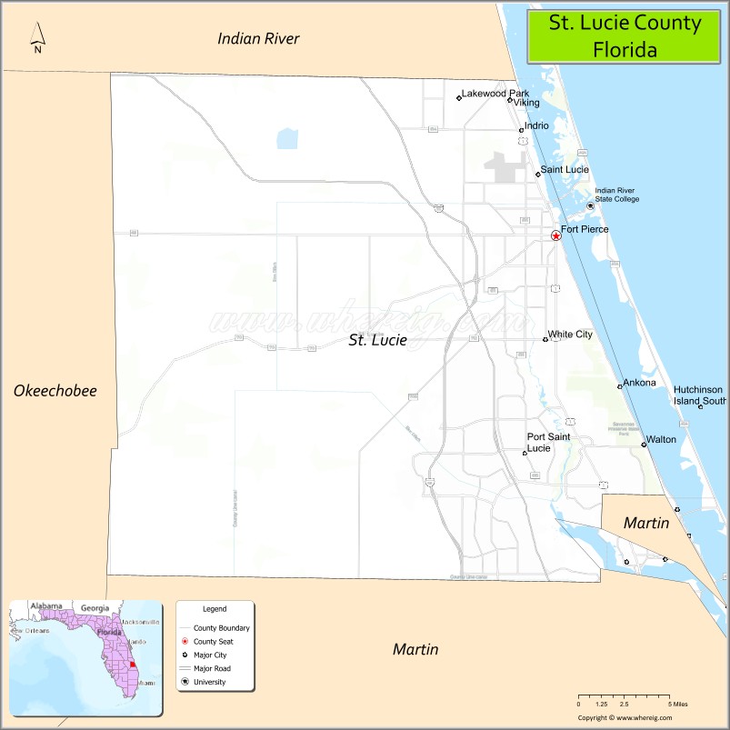
About St. Lucie County Map, Florida: The map showing the county boundary, county seat, major cities, highways, water bodies and neighbouring counties.
Most Viewed Links
About St. Lucie County, Florida
St. Lucie County is located in the southeastern part of Florida, in the state of the United States. The county was established in 1905 and was named after the St. Lucie River and St. Lucie Inlet. The county seat is Fort Pierce, and the largest city is Port St. Lucie. St. Lucie County is part of Florida’s Treasure Coast region and is known for its coastal communities, growing residential development, and marine industries.
Population
According to the United States Census Bureau, the population of St. Lucie County is 329,226 as recorded in the 2020 Census, and the population density is approximately 572 people per square mile.
Area and Geography
According to the United States Census Bureau, St. Lucie County covers a total area of approximately 688 square miles (about 1,782 square kilometers), including about 572 square miles (1,481 square kilometers) of land and 116 square miles (301 square kilometers) of water. The county features Atlantic Ocean coastline, the Indian River Lagoon, inland agricultural areas, and expanding suburban neighborhoods.
Bordering Counties
St. Lucie County shares boundaries with Indian River County to the north, Martin County to the south, and Osceola County to the west.
Major Cities and Communities
Major cities and towns include Port St. Lucie, Fort Pierce, St. Lucie Village, and Lakewood Park.
Attractions and Recreation
St. Lucie County offers beaches, waterfront parks, boating, and fishing along the Atlantic coast and Indian River Lagoon. Cultural and historical attractions are centered in Fort Pierce, including museums and waterfront districts. The county is also home to Indian River State College, contributing to higher education and workforce training in the region.
Transportation
St. Lucie County is served by Interstate 95 and Florida’s Turnpike, providing major north-south connectivity along Florida’s east coast. U.S. Highway 1 runs through coastal communities, supporting local and regional travel.
Explore more counties in Florida Counties or view the complete USA States Map section for additional geographic information.
Sources:
Population and area data sourced from the United States Census Bureau (2020 Census). General county information referenced from the Official St. Lucie County Government Website.
Facts about St. Lucie County, Florida
| Country | United States |
| State | Florida |
| Region | Treasure Coast |
| County Seat | Fort Pierce |
| Named After | St. Lucie River |
| Established | 1905 |
| Organized | 1905 |
| Coordinates | 27.3764° N, 80.4487° W |
| Total Area | 688 sq mi |
| Land Area | 573 sq mi |
| Water Area | 115 sq mi |
| Population (2020) | 329,226 |
| Population Rank | Mid-sized coastal county in Southeast Florida |
| Major City | Port St. Lucie |
| Main Industries | Healthcare, Tourism, Construction, Manufacturing |
| Major Airport | St. Lucie County International Airport |
| Time Zone | Eastern Time (UTC−05:00) |
| Known For | Treasure Coast beaches, Port St. Lucie growth, marine research |
| Website | https://www.stlucieco.gov |
Top Attractions in St. Lucie County, Florida
- Fort Pierce Inlet State Park – Beaches, snorkeling, and fishing.
- Downtown Fort Pierce – Marina, dining, and history.
- Manatee Observation & Education Center – Manatee viewing and exhibits.
- St. Lucie County Aquarium – Marine life displays.
- Jetty Park – Fishing and inlet views.
- Savannas Preserve State Park – Wetlands and trails.
- Heathcote Botanical Gardens – Bonsai and tropical plants.
- St. Lucie Inlet Preserve State Park – Beaches and nature trails.
- Port St. Lucie Botanical Gardens – Gardens and walking paths.
- Scenic Indian River Lagoon Drives – Water and wildlife views.