Map of Indian River County - Indian River County is a county located in the U.S. state of Florida. Indian River County Map showing cities, highways, important places and water bodies. Get Where is Indian River County located in the map, major cities in Indian River county, population, areas, and places of interest.
Map of Indian River County, Florida
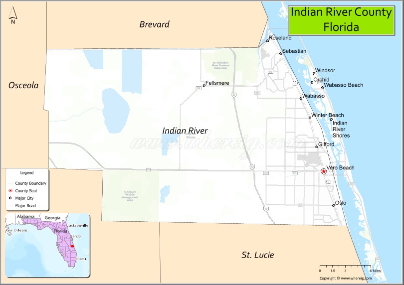
About Indian River County Map, Florida: The map showing the county boundary, county seat, major cities, highways, water bodies and neighbouring counties.
Most Viewed Links
About Indian River County, Florida
Indian River County is located in the east-central part of Florida, in the state of the United States. The county was established in 1925 and was named after the Indian River Lagoon, which borders much of its eastern shoreline. The county seat and largest city is Vero Beach. Indian River County is part of Florida’s Treasure Coast and is known for its coastal communities, citrus production, and growing residential areas.
Population
According to the United States Census Bureau, the population of Indian River County is 159,788 as recorded in the 2020 Census, and the population density is approximately 316 people per square mile.
Area and Geography
According to the United States Census Bureau, Indian River County covers a total area of approximately 617 square miles (about 1,598 square kilometers), including about 503 square miles (1,303 square kilometers) of land and 114 square miles (295 square kilometers) of water. The county features Atlantic Ocean coastline, barrier islands, the Indian River Lagoon, and inland agricultural lands.
Bordering Counties
Indian River County shares boundaries with Brevard County to the north, Osceola County to the west, Okeechobee County to the southwest, and St. Lucie County to the south.
Major Cities and Communities
Major cities and towns include Vero Beach, Sebastian, Fellsmere, Indian River Shores, and Orchid.
Attractions and Recreation
Indian River County offers beaches, boating, fishing, and cultural attractions along the Atlantic coast and Indian River Lagoon. The county features parks, wildlife refuges, and waterfront communities that support tourism and outdoor recreation. Indian River State College provides higher education access and workforce development opportunities in the region.
Transportation
Indian River County is served by Interstate 95 and U.S. Highway 1, providing north-south connectivity along Florida’s east coast. State Road 60 runs east-west through Vero Beach, linking inland communities with the coast.
Explore more counties in Florida Counties or view the complete USA States Map section for additional geographic information.
Sources:
Population and area data sourced from the United States Census Bureau (2020 Census). General county information referenced from the Official Indian River County Government Website.
Facts about Indian River County, Florida
| Country | United States |
| State | Florida |
| Region | Treasure Coast |
| County Seat | Vero Beach |
| Named After | Indian River Lagoon |
| Established | 1925 |
| Organized | 1925 |
| Coordinates | 27.6948° N, 80.5438° W |
| Total Area | 616 sq mi |
| Land Area | 503 sq mi |
| Water Area | 113 sq mi |
| Population (2020) | 159,788 |
| Population Rank | Mid-sized county on Florida’s east coast |
| Major City | Vero Beach |
| Main Industries | Tourism, Agriculture, Healthcare, Aviation |
| Major Airport | Vero Beach Regional Airport |
| Time Zone | Eastern Time (UTC−05:00) |
| Known For | Indian River Lagoon, citrus industry, Atlantic beaches |
| Website | https://www.ircgov.com |
Ctities in Indian River county
| City Name | Type | Population (2020) | Pop. Density | Area | Incorporated |
|---|---|---|---|---|---|
| Fellsmere | City | 4,834 | 5.4 sq mi (14.0 km2) | 1911 | |
| Indian River Shores | Town | 4,241 | 7.2 sq mi (18.5 km2) | 1953 | |
| Orchid | Town | 516 | 1.8 sq mi (4.8 km2) | 1965 | |
| Sebastian | City | 25,054 | 13.5 sq mi (35.1 km2) | 1924 | |
| Vero Beach | City | 16,354 | 12.9 sq mi (33.5 km2) | 1919 |
Top Attractions in Indian River County, Florida
- Vero Beach – Atlantic beaches and seaside charm.
- McKee Botanical Garden – Tropical gardens and walkways.
- Environmental Learning Center – Mangrove boardwalks and wildlife.
- Pelican Island National Wildlife Refuge – Birdwatching and kayaking.
- Downtown Vero Beach – Shops, dining, and arts.
- Indian River Citrus Museum – Citrus industry history.
- Riverside Theatre – Live performances and events.
- Round Island Riverside Park – Riverfront trails and views.
- Wabasso Beach – Quiet beach access.
- Scenic Coastal Drives – Lagoon and ocean views.
- Alachua County Map
- Baker County Map
- Bay County Map
- Bradford County Map
- Brevard County Map
- Broward County Map
- Calhoun County Map
- Charlotte County Map
- Citrus County Map
- Clay County Map
- Collier County Map
- Columbia County Map
- DeSoto County Map
- Dixie County Map
- Duval County Map
- Escambia County Map
- Flagler County Map
- Franklin County Map
- Gadsden County Map
- Gilchrist County Map
- Glades County Map
- Gulf County Map
- Hamilton County Map
- Hardee County Map
- Hendry County Map
- Hernando County Map
- Highlands County Map
- Hillsborough County Map
- Holmes County Map
- Indian River County Map
- Jackson County Map
- Jefferson County Map
- Lafayette County Map
- Lake County Map
- Lee County Map
- Leon County Map
- Levy County Map
- Liberty County Map
- Madison County Map
- Manatee County Map
- Marion County Map
- Martin County Map
- Miami-Dade County Map
- Monroe County Map
- Nassau County Map
- Okaloosa County Map
- Okeechobee County Map
- Orange County Map
- Osceola County Map
- Palm Beach County Map
- Pasco County Map
- Pinellas County Map
- Polk County Map
- Putnam County Map
- St Johns County Map
- St Lucie County Map
- Santa Rosa County Map
- Sarasota County Map
- Seminole County Map
- Sumter County Map
- Suwannee County Map
- Taylor County Map
- Union County Map
- Volusia County Map
- Wakulla County Map
- Walton County Map
- Washington County Map
- Where is Miami
- Where is Hialeah
- Where is Jacksonville
- Where is Orlando
- Where is Saint Petersburg
- Where is Tampa
- Where is Alafaya
- Where is Boca Raton
- Where is Boynton Beach
- Where is Brandon
- Where is Cape Coral
- Where is Clearwater
- Where is Coral Springs
- Where is Davie
- Where is Daytona Beach
- Where is Deerfield Beach
- Where is Deltona
- Where is Doral
- Where is Fort Lauderdale
- Where is Fort Myers
- Where is Gainesville
- Where is Hollywood
- Where is Homestead
- Where is Horizon West
- Where is Kendall
- Where is Kissimmee
- Where is Lakeland
- Where is Largo
- Where is Lauderhill
- Where is Lehigh Acres
- Where is Melbourne
- Where is Miami Beach
- Where is Miami Gardens
- Where is Miramar
- Where is North Port
- Where is Palm Bay
- Where is Palm Coast
- Where is Pembroke Pines
- Where is Plantation
- Where is Poinciana
- Where is Pompano Beach
- Where is Port St. Lucie
- Where is Riverview
- Where is Spring Hill
- Where is St. Petersburg
- Where is Sunrise
- Where is Tallahassee
- Where is Tamarac
- Where is The Villages
- Where is Town 'n' Country
- Where is West Palm Beach