Map of Kent County - Kent County is a county located in the U.S. state of Delaware. Kent County Map showing cities, highways, important places and water bodies. Get Where is Kent County located in the map, major cities in Kent county, population, areas, and places of interest.
Map of Kent County, Delaware
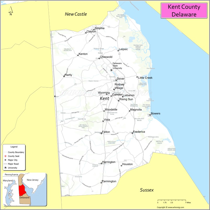
About Kent County Map, Delaware: The map showing the county boundary, county seat, major cities, highways, water bodies and neighbouring counties.
Most Viewed Links
Map of Kent County, Delaware
Bay County is a county located in the U.S. state of Florida. It`s county seat is Panama City. As per 2020 census, the population of Bay County was 179168 and population density of Bay was 234.51square miles. According to the United States Census Bureau, the county has a total area of 764 sq mi (1,979 km2). Bay County was established on 1913.
Kent County Facts
| Continent | North America |
| Country | United States |
| State | Delaware |
| County Seat | Dover |
| Largest City/Town | Dover |
| Established | 1683 |
| Total Area | 801 sq mi (2,074 sq km) |
| Land Area | 586 sq mi (1,518 sq km) |
| Water Area | 215 sq mi (557 sq km) |
| Population | 181,851 (Census 2020) |
| Population Density | 310 people per sq mi |
| Time Zone | Eastern Time Zone (ET) |
| Major Highways | U.S. Route 13, U.S. Route 113, Delaware Route 1, Delaware Route 8 |
| Major Rivers | St. Jones River, Murderkill River, Mispillion River |
| Neighboring Counties | New Castle County, Sussex County, Queen Anne's County (Maryland), Caroline County (Maryland) |
| Famous For | Dover Air Force Base, Delaware State Capitol, NASCAR racing, agriculture, coastal wetlands |
| Top Attractions | Dover Motor Speedway, First State Heritage Park, Bombay Hook National Wildlife Refuge, Delaware Agricultural Museum, John Dickinson Plantation |
| Official Website | Official Website |
About Kent County, Delaware
Kent County is located in central Delaware in the United States and was established in 1683. Dover serves as both the county seat and largest city and is also the capital of Delaware. The county is known for government institutions, Dover Air Force Base, NASCAR racing, farming, wildlife refuges, and historic attractions throughout central Delaware.
Cities and Towns in Kent County, Delaware
| City/Town | Population (Census 2020) | Latitude & Longitude |
|---|---|---|
| Dover (county seat) | 39,403 | 39.1582°N, 75.5244°W |
| Smyrna | 12,883 | 39.2998°N, 75.6046°W |
| Milford | 11,190 | 38.9126°N, 75.4277°W |
| Camden | 3,715 | 39.1137°N, 75.5419°W |
| Harrington | 3,735 | 38.9237°N, 75.5777°W |
| Felton | 1,568 | 39.0093°N, 75.5774°W |
| Frederica | 774 | 39.0090°N, 75.4660°W |
| Houston | 405 | 38.9201°N, 75.4991°W |
| Wyoming | 1,806 | 39.1146°N, 75.5591°W |
| Bowers | 335 | 39.0587°N, 75.3985°W |
Golf Courses in Kent County, Delaware
| Golf Course | Location | Latitude & Longitude |
|---|---|---|
| Maple Dale Country Club | Dover | 39.1770°N, 75.5518°W |
| Jonathan's Landing Golf Club | Magnolia | 39.0657°N, 75.4921°W |
| Wild Quail Golf & Country Club | Wyoming | 39.0992°N, 75.5788°W |
Roads and Highways in Kent County
Major highways connect the county with Wilmington, Maryland, and Delaware beach communities.
- U.S. Route 13 - major north-south highway through central Delaware
- U.S. Route 113 - regional route connecting Milford with southern Delaware
- Delaware Route 1 - primary limited-access highway serving the Delaware coast
- Delaware Route 8 - east-west route through Dover and nearby towns
- Delaware Route 10 - connector roadway across central Delaware
Neighboring Counties of Kent County
- New Castle County (north)
- Sussex County (south)
- Queen Anne's County, Maryland (west)
- Caroline County, Maryland (southwest)
Top Attractions in Kent County, Delaware
The county offers historic sites, wildlife refuges, racing attractions, and cultural landmarks throughout central Delaware.
- Dover Motor Speedway - major NASCAR racing venue and entertainment complex
- First State Heritage Park - historic district showcasing Delaware history and government buildings
- Bombay Hook National Wildlife Refuge - birdwatching, marshlands, and scenic wildlife drives
- Delaware Agricultural Museum - exhibits on farming history and rural heritage
- John Dickinson Plantation - historic home of a Founding Father of the United States
- Dover Air Force Base Air Mobility Command Museum - military aircraft exhibits and aviation history
- Downtown Dover Historic District - colonial architecture, museums, and local shops
- Killens Pond State Park - boating, hiking, camping, and water park recreation
- Biggs Museum of American Art - regional art collections and cultural exhibits
- Bowers Beach - small coastal community with fishing and bayfront scenery
Distance from Kent County to Nearby Cities
The following distances are measured by road (driving).
- Dover to Wilmington (New Castle County), Delaware - 52 mi (84 km)
- Dover to Georgetown (Sussex County), Delaware - 39 mi (63 km)
- Dover to Baltimore (Baltimore City), Maryland - 88 mi (142 km)
- Dover to Annapolis (Anne Arundel County), Maryland - 69 mi (111 km)
- Dover to Philadelphia (Philadelphia County), Pennsylvania - 87 mi (140 km)
- Dover to Atlantic City (Atlantic County), New Jersey - 118 mi (190 km)
- Dover to Washington, D.C. - 104 mi (167 km)
- Dover to New York City (New York County), New York - 176 mi (283 km)
- Dover to Richmond (Richmond City), Virginia - 207 mi (333 km)
- Dover to Pittsburgh (Allegheny County), Pennsylvania - 312 mi (502 km)
- Dover to Boston (Suffolk County), Massachusetts - 387 mi (623 km)
- Dover to Charlotte (Mecklenburg County), North Carolina - 468 mi (753 km)
FAQs about Kent County
Kent County is located in central Delaware.
Kent County has a population of 181,851 according to the Census 2020.
The county is known for Dover Air Force Base, NASCAR racing, agriculture, and Delaware government institutions.
Major highways include U.S. Route 13, U.S. Route 113, Delaware Route 1, and Delaware Route 8.
Yes, Kent County has golf facilities including Maple Dale Country Club and Wild Quail Golf & Country Club.
References
- QuickFacts - U.S. Census Bureau
- United States Census Bureau
- United States Geological Survey (USGS)
- Official Website
- State of Delaware Official Website
- Alabama Counties
- Alaska boroughs
- Arizona Counties
- Arkansas Counties
- California County Map
- Colorado Counties
- Connecticut Counties
- Delaware Counties
- Florida County Map
- Georgia County Map
- Hawaii Counties
- Idaho Counties
- Illinois Counties
- Indiana Counties
- Iowa Counties
- Kansas Counties
- Kentucky Counties
- Louisiana Counties
- Maine Counties
- Maryland Counties
- Massachusetts Counties
- Michigan County Map
- Minnesota Counties
- Mississippi Counties
- Missouri Counties
- Montana Counties
- Nebraska Counties
- Nevada Counties
- New York Counties
- New Hampshire Counties
- New Jersey Counties
- New Mexico Counties
- North Carolina Counties
- North Dakota Counties
- Ohio County Map
- Oklahoma Counties
- Oregon Counties
- Pennsylvania Counties
- Rhode Island Counties
- South Carolina Counties
- South Dakota Counties
- Map of Tennessee
- Texas County Map
- Utah Counties
- Vermont Counties
- Virginia Counties
- Washington Counties
- West Virginia Counties
- Wisconsin Counties
- Wyoming Counties