Map of Sussex County - Sussex County is a county located in the U.S. state of Delaware. Sussex County Map showing cities, highways, important places and water bodies. Get Where is Sussex County located in the map, major cities in Sussex county, population, areas, and places of interest.
Map of Sussex County, Delaware
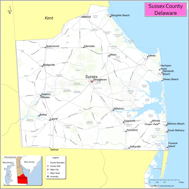
About Sussex County Map, Delaware: The map showing the county boundary, county seat, major cities, highways, water bodies and neighbouring counties.
Most Viewed Links
Map of Sussex County, Delaware
Brevard County is a county located in the U.S. state of Florida. It`s county seat is Titusville. As per 2020 census, the population of Brevard County was 616628 and population density of Brevard was 605.72square miles. According to the United States Census Bureau, the county has a total area of 1,018 sq mi (2,637 km2). Brevard County was established on 1844.
Sussex County Facts
| Continent | North America |
| Country | United States |
| State | Delaware |
| County Seat | Georgetown |
| Largest City/Town | Seaford |
| Established | 1683 |
| Total Area | 1,196 sq mi (3,098 sq km) |
| Land Area | 936 sq mi (2,424 sq km) |
| Water Area | 260 sq mi (673 sq km) |
| Population | 255,346 (Census 2020) |
| Population Density | 273 people per sq mi |
| Time Zone | Eastern Time Zone (ET) |
| Major Highways | U.S. Route 9, U.S. Route 13, U.S. Route 113, Delaware Route 1 |
| Major Rivers | Nanticoke River, Broadkill River, Indian River |
| Neighboring Counties | Kent County (Delaware), Wicomico County (Maryland), Worcester County (Maryland), Caroline County (Maryland) |
| Famous For | Delaware beaches, coastal tourism, poultry farming, fishing, resort communities |
| Top Attractions | Rehoboth Beach, Cape Henlopen State Park, Bethany Beach, Fenwick Island, Delaware Seashore State Park |
| Official Website | Official Website |
About Sussex County, Delaware
Sussex County is located in southern Delaware in the United States along the Atlantic coast and was established in 1683. Georgetown serves as the county seat while Seaford is the largest city. The county is known for popular beach resorts, coastal tourism, seafood, agriculture, boating, and outdoor recreation along Delaware’s Atlantic shoreline.
Cities and Towns in Sussex County, Delaware
| City/Town | Population (Census 2020) | Latitude & Longitude |
|---|---|---|
| Seaford | 8,325 | 38.6412°N, 75.6110°W |
| Georgetown (county seat) | 7,134 | 38.6901°N, 75.3855°W |
| Rehoboth Beach | 1,108 | 38.7209°N, 75.0760°W |
| Lewes | 3,303 | 38.7746°N, 75.1393°W |
| Milford | 11,190 | 38.9126°N, 75.4277°W |
| Bethany Beach | 1,060 | 38.5396°N, 75.0552°W |
| Fenwick Island | 343 | 38.4626°N, 75.0524°W |
| Laurel | 4,436 | 38.5565°N, 75.5713°W |
| Bridgeville | 2,568 | 38.7426°N, 75.6038°W |
| Millsboro | 6,168 | 38.5915°N, 75.2913°W |
Golf Courses in Sussex County, Delaware
| Golf Course | Location | Latitude & Longitude |
|---|---|---|
| Bayside Resort Golf Club | Selbyville | 38.4702°N, 75.1015°W |
| Kings Creek Country Club | Rehoboth Beach | 38.7101°N, 75.1079°W |
| The Peninsula Golf & Country Club | Millsboro | 38.6244°N, 75.1925°W |
Roads and Highways in Sussex County
Major highways connect the county with Delaware beach resorts, Maryland, and central Delaware.
- U.S. Route 9 - east-west highway connecting Georgetown with coastal communities
- U.S. Route 13 - major north-south highway through western Sussex County
- U.S. Route 113 - regional route linking Dover with the Maryland border
- Delaware Route 1 - primary coastal highway serving beach tourism areas
- Delaware Route 404 - connector route toward Maryland’s Eastern Shore
Neighboring Counties of Sussex County
- Kent County, Delaware (north)
- Wicomico County, Maryland (west)
- Worcester County, Maryland (south)
- Caroline County, Maryland (northwest)
Top Attractions in Sussex County, Delaware
The county offers beaches, coastal parks, seafood dining, and outdoor recreation along the Atlantic Ocean.
- Rehoboth Beach - popular resort town with boardwalk, shopping, and beaches
- Cape Henlopen State Park - beaches, biking trails, dunes, and historic military sites
- Bethany Beach - family-friendly coastal resort community
- Fenwick Island - beach destination near the Maryland border
- Delaware Seashore State Park - ocean beaches, fishing, camping, and boating
- Lewes Historic District - colonial architecture and waterfront attractions
- Jungle Jim's Water Park - family entertainment attraction near Rehoboth Beach
- Indian River Inlet - fishing, boating, and scenic coastal views
- Prime Hook National Wildlife Refuge - birdwatching and marshland habitats
- Tanger Outlets Rehoboth Beach - popular tax-free shopping destination
Distance from Sussex County to Nearby Cities
The following distances are measured by road (driving).
- Georgetown to Dover (Kent County), Delaware - 39 mi (63 km)
- Georgetown to Wilmington (New Castle County), Delaware - 91 mi (146 km)
- Georgetown to Ocean City (Worcester County), Maryland - 33 mi (53 km)
- Georgetown to Baltimore (Baltimore City), Maryland - 108 mi (174 km)
- Georgetown to Annapolis (Anne Arundel County), Maryland - 91 mi (146 km)
- Georgetown to Philadelphia (Philadelphia County), Pennsylvania - 124 mi (200 km)
- Georgetown to Washington, D.C. - 122 mi (196 km)
- Georgetown to Atlantic City (Atlantic County), New Jersey - 153 mi (246 km)
- Georgetown to New York City (New York County), New York - 214 mi (344 km)
- Georgetown to Richmond (Richmond City), Virginia - 213 mi (343 km)
- Georgetown to Charlotte (Mecklenburg County), North Carolina - 473 mi (761 km)
- Georgetown to Boston (Suffolk County), Massachusetts - 425 mi (684 km)
FAQs about Sussex County
Sussex County is located in southern Delaware along the Atlantic coast.
Sussex County has a population of 255,346 according to the Census 2020.
The county is known for Delaware beaches, coastal tourism, seafood, and resort communities.
Major highways include U.S. Route 9, U.S. Route 13, U.S. Route 113, and Delaware Route 1.
Yes, Sussex County has golf facilities including Bayside Resort Golf Club and The Peninsula Golf & Country Club.
References
- QuickFacts - U.S. Census Bureau
- United States Census Bureau
- United States Geological Survey (USGS)
- Official Website
- State of Delaware Official Website
- Alabama Counties
- Alaska boroughs
- Arizona Counties
- Arkansas Counties
- California County Map
- Colorado Counties
- Connecticut Counties
- Delaware Counties
- Florida County Map
- Georgia County Map
- Hawaii Counties
- Idaho Counties
- Illinois Counties
- Indiana Counties
- Iowa Counties
- Kansas Counties
- Kentucky Counties
- Louisiana Counties
- Maine Counties
- Maryland Counties
- Massachusetts Counties
- Michigan County Map
- Minnesota Counties
- Mississippi Counties
- Missouri Counties
- Montana Counties
- Nebraska Counties
- Nevada Counties
- New York Counties
- New Hampshire Counties
- New Jersey Counties
- New Mexico Counties
- North Carolina Counties
- North Dakota Counties
- Ohio County Map
- Oklahoma Counties
- Oregon Counties
- Pennsylvania Counties
- Rhode Island Counties
- South Carolina Counties
- South Dakota Counties
- Map of Tennessee
- Texas County Map
- Utah Counties
- Vermont Counties
- Virginia Counties
- Washington Counties
- West Virginia Counties
- Wisconsin Counties
- Wyoming Counties