Map of Lamoille County - Lamoille County is a county located in the U.S. state of Vermont. Lamoille County Map showing cities, highways, important places and water bodies. Get Where is Lamoille County located in the map, major cities in Lamoille county, population, areas, and places of interest.
Map of Lamoille County, Vermont
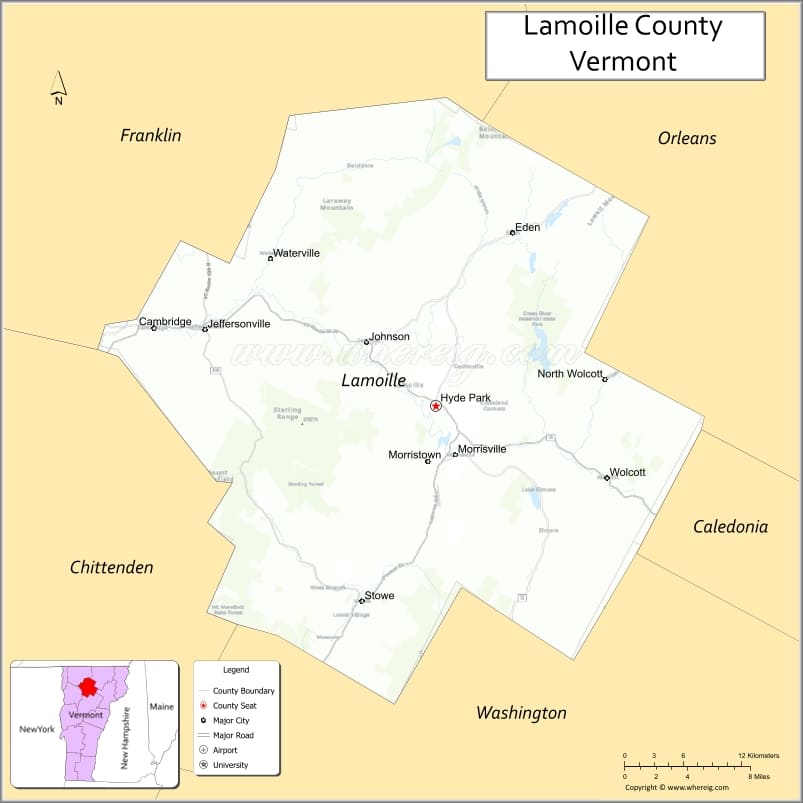
About Lamoille County Map, Alabama: The map showing the county boundary, county seat, major cities, highways, water bodies and neighbouring counties.
Most Viewed Links
Map of Lamoille County, Vermont
Wythe County is a county located in the U.S. state of Virginia. It`s county seat is Wytheville. As per 2020 census, the population of Wythe County was 28178 and population density of Wythe was square miles. According to the United States Census Bureau, the county has a total area of 463 sq mi (1,199 km2). Wythe County was established on 1790.
Lamoille County Facts
| Continent | North America |
| Country | United States |
| State | Vermont |
| County Seat | Hyde Park |
| Largest City/Town | Morristown |
| Established | 1835 |
| Total Area | 464 sq mi (1,202 sq km) |
| Land Area | 459 sq mi (1,189 sq km) |
| Water Area | 5 sq mi (13 sq km) |
| Population | 25,945 (Census 2020) |
| Population Density | 56.5 people per sq mi |
| Time Zone | Eastern Time Zone (ET) |
| Major Highways | VT Route 15, VT Route 100, VT Route 108, VT Route 12, VT Route 109 |
| Major Rivers | Lamoille River, Green River, Brewster River |
| Neighboring Counties | Franklin County, Orleans County, Caledonia County, Washington County, Chittenden County |
| Famous For | Stowe Mountain Resort, Green Mountains, skiing, hiking, covered bridges, and scenic byways |
| Top Attractions | Stowe Mountain Resort, Smugglers' Notch, Moss Glen Falls, Lamoille Valley Rail Trail, Green River Reservoir |
| Official Website | Official Website |
About Lamoille County, Vermont
Lamoille County is located in north-central Vermont and was established in 1835. The county seat is Hyde Park, while Morristown is the largest town in the county. Lamoille County is widely known for mountain recreation, ski resorts, scenic highways, and outdoor activities throughout the Green Mountains region.
Cities and Towns in Lamoille County, Vermont
| City/Town | Population (Census 2020) | Latitude & Longitude |
|---|---|---|
| Hyde Park (county seat) | 2,994 | 44.5937°N, 72.6140°W |
| Morristown | 5,455 | 44.5587°N, 72.5982°W |
| Stowe | 5,223 | 44.4654°N, 72.6874°W |
| Cambridge | 4,344 | 44.6406°N, 72.8765°W |
| Johnson | 3,491 | 44.6356°N, 72.6804°W |
| Wolcott | 1,670 | 44.5517°N, 72.4618°W |
| Eden | 1,338 | 44.7076°N, 72.5468°W |
| Belvidere | 358 | 44.7051°N, 72.7182°W |
| Elmore | 862 | 44.5234°N, 72.5301°W |
| Waterville | 686 | 44.6934°N, 72.7582°W |
| Jeffersonville (CDP) | 729 | 44.6437°N, 72.8270°W |
| Morrisville (CDP) | 2,092 | 44.5611°N, 72.5989°W |
| Stowe Village (CDP) | 495 | 44.4650°N, 72.6871°W |
| North Hyde Park (CDP) | 331 | 44.6228°N, 72.6123°W |
Best Golf Courses in Lamoille County, Vermont
| Golf Course | Location | Latitude & Longitude |
|---|---|---|
| Stowe Country Club | Stowe | 44.4658°N, 72.7046°W |
| Ryder Brook Golf Club | Morristown | 44.5659°N, 72.6067°W |
| Brewster Ridge Disc Golf Course | Jeffersonville | 44.6421°N, 72.8258°W |
| West Branch Golf Club | Stowe | 44.4907°N, 72.7162°W |
| Eden Recreation Golf Area | Eden | 44.7083°N, 72.5475°W |
What are Major Roads and Highways in Lamoille County
Major highways connect the county to nearby regions and cities.
- VT Route 15 - major east-west highway connecting Morrisville, Johnson, and Cambridge with neighboring counties
- VT Route 100 - scenic north-south route linking Stowe with ski resorts and mountain towns
- VT Route 108 - mountain road passing through Smugglers' Notch between Stowe and Jeffersonville
- VT Route 12 - connects Morristown with Montpelier and northern Vermont communities
- VT Route 109 - rural scenic highway connecting Belvidere and Waterville
Neighboring Counties of Lamoille County
- Franklin County (northwest)
- Orleans County (northeast)
- Caledonia County (east)
- Washington County (south)
- Chittenden County (west)
What are Top Attractions in Lamoille County, Vermont
The county offers a mix of natural and cultural attractions.
| Main Sight Name | City | Famous For |
|---|---|---|
| Stowe Mountain Resort | Stowe | Skiing, snowboarding, and mountain recreation |
| Smugglers' Notch State Park | Stowe | Mountain pass, hiking, and scenic drives |
| Moss Glen Falls | Stowe | Popular waterfall and photography spot |
| Lamoille Valley Rail Trail | Morristown | Biking, walking, and snowmobile recreation |
| Green River Reservoir State Park | Hyde Park | Remote paddling and camping area |
| Mount Mansfield Nearby Area | Stowe | Highest mountain in Vermont and hiking destination |
| Cold Hollow Cider Mill | Waterbury Center Area | Fresh cider, maple products, and Vermont foods |
| Rock Art Brewery | Morristown | Craft brewery and local beer tasting |
| Trapp Family Lodge | Stowe | Austrian-style resort and cross-country skiing |
| Elmore State Park | Elmore | Swimming, hiking, and lake recreation |
| Cambridge Junction Covered Bridge | Cambridge | Historic Vermont covered bridge |
| Sterling Pond Trail | Stowe | Mountain hiking trail with alpine scenery |
Distance from Lamoille County to Nearby Cities
The following distances are measured by road (driving).
- Hyde Park to Burlington (Chittenden County), Vermont - 45 mi (72 km)
- Hyde Park to Montpelier (Washington County), Vermont - 31 mi (50 km)
- Hyde Park to St. Albans (Franklin County), Vermont - 37 mi (60 km)
- Hyde Park to Newport (Orleans County), Vermont - 39 mi (63 km)
- Hyde Park to Stowe (Lamoille County), Vermont - 12 mi (19 km)
- Hyde Park to Morrisville (Lamoille County), Vermont - 3 mi (5 km)
- Hyde Park to Barre (Washington County), Vermont - 36 mi (58 km)
- Hyde Park to Middlebury (Addison County), Vermont - 67 mi (108 km)
- Hyde Park to Rutland (Rutland County), Vermont - 92 mi (148 km)
- Hyde Park to Plattsburgh, New York - 72 mi (116 km)
- Hyde Park to Montreal, Quebec - 96 mi (154 km)
- Hyde Park to Concord, New Hampshire - 120 mi (193 km)
- Hyde Park to Littleton, New Hampshire - 71 mi (114 km)
- Hyde Park to Albany, New York - 167 mi (269 km)
References
- QuickFacts - U.S. Census Bureau
- United States Census Bureau
- United States Geological Survey (USGS)
- National Geodetic Survey
- Official Website
- Alabama Counties
- Alaska boroughs
- Arizona Counties
- Arkansas Counties
- California County Map
- Colorado Counties
- Connecticut Counties
- Delaware Counties
- Florida County Map
- Georgia County Map
- Hawaii Counties
- Idaho Counties
- Illinois Counties
- Indiana Counties
- Iowa Counties
- Kansas Counties
- Kentucky Counties
- Louisiana Counties
- Maine Counties
- Maryland Counties
- Massachusetts Counties
- Michigan County Map
- Minnesota Counties
- Mississippi Counties
- Missouri Counties
- Montana Counties
- Nebraska Counties
- Nevada Counties
- New York Counties
- New Hampshire Counties
- New Jersey Counties
- New Mexico Counties
- North Carolina Counties
- North Dakota Counties
- Ohio County Map
- Oklahoma Counties
- Oregon Counties
- Pennsylvania Counties
- Rhode Island Counties
- South Carolina Counties
- South Dakota Counties
- Map of Tennessee
- Texas County Map
- Utah Counties
- Vermont Counties
- Virginia Counties
- Washington Counties
- West Virginia Counties
- Wisconsin Counties
- Wyoming Counties