Map of Orange County - Orange County is a county located in the U.S. state of Vermont. Orange County Map showing cities, highways, important places and water bodies. Get Where is Orange County located in the map, major cities in Orange county, population, areas, and places of interest.
Map of Orange County, Vermont
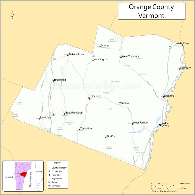
About Orange County Map, Alabama: The map showing the county boundary, county seat, major cities, highways, water bodies and neighbouring counties.
Most Viewed Links
Map of Orange County, Vermont
York County is a county located in the U.S. state of Virginia. It`s county seat is Yorktown. As per 2020 census, the population of York County was 70915 and population density of York was square miles. According to the United States Census Bureau, the county has a total area of 106 sq mi (275 km2). York County was established on 1634.
Orange County Facts
| Continent | North America |
| Country | United States |
| State | Vermont |
| County Seat | Chelsea |
| Largest City/Town | Randolph |
| Established | 1781 |
| Total Area | 693 sq mi (1,795 sq km) |
| Land Area | 687 sq mi (1,779 sq km) |
| Water Area | 6 sq mi (16 sq km) |
| Population | 29,018 (Census 2020) |
| Population Density | 42.2 people per sq mi |
| Time Zone | Eastern Time Zone (ET) |
| Major Highways | Interstate 89, U.S. Route 302, VT Route 14, VT Route 25, VT Route 110 |
| Major Rivers | White River, Connecticut River, First Branch White River |
| Neighboring Counties | Washington County, Caledonia County, Windsor County, Addison County, Grafton County (NH) |
| Famous For | Rolling hills, covered bridges, Vermont villages, maple syrup, and outdoor recreation |
| Top Attractions | Vermont Institute of Natural Science, Lake Fairlee, Tunbridge Fairgrounds, Chelsea Green, White River |
| Official Website | Official Website |
About Orange County, Vermont
Orange County is located in east-central Vermont along the New Hampshire border and was established in 1781. The county seat is Chelsea, while Randolph is the largest town in the county. Orange County is known for its scenic countryside, historic villages, covered bridges, farms, and outdoor recreation areas along the White River Valley.
Cities and Towns in Orange County, Vermont
| City/Town | Population (Census 2020) | Latitude & Longitude |
|---|---|---|
| Chelsea (county seat) | 1,258 | 43.9895°N, 72.4470°W |
| Randolph | 4,774 | 43.9256°N, 72.6651°W |
| Bradford | 2,872 | 43.9920°N, 72.1287°W |
| Fairlee | 988 | 43.9087°N, 72.1420°W |
| Thetford | 2,775 | 43.8329°N, 72.2462°W |
| Tunbridge | 1,185 | 43.8945°N, 72.4937°W |
| Vershire | 672 | 43.9248°N, 72.3071°W |
| Washington | 1,090 | 44.1056°N, 72.4279°W |
| Williamstown | 3,515 | 44.1192°N, 72.5415°W |
| West Fairlee | 652 | 43.9034°N, 72.2448°W |
| Braintree | 1,216 | 43.9578°N, 72.7101°W |
| Brookfield | 1,292 | 44.0306°N, 72.5721°W |
| Corinth | 1,466 | 44.0089°N, 72.2873°W |
| Newbury | 2,168 | 44.0792°N, 72.0362°W |
| Orange | 1,042 | 44.1090°N, 72.3812°W |
| Strafford | 1,098 | 43.8687°N, 72.3726°W |
| Topsham | 1,141 | 44.1234°N, 72.2048°W |
| Randolph Center (CDP) | 584 | 43.9498°N, 72.6034°W |
| Bradford Village (CDP) | 928 | 43.9924°N, 72.1289°W |
| East Corinth (CDP) | 510 | 44.0251°N, 72.2385°W |
Best Golf Courses in Orange County, Vermont
| Golf Course | Location | Latitude & Longitude |
|---|---|---|
| Montague Golf Club | Randolph | 43.9251°N, 72.6640°W |
| Lake Morey Resort Golf Club | Fairlee | 43.9002°N, 72.1426°W |
| Bradford Country Club | Bradford | 43.9975°N, 72.1261°W |
| Rocks Estate Golf Area | Strafford | 43.8670°N, 72.3742°W |
What are Major Roads and Highways in Orange County
Major highways connect the county to nearby regions and cities.
- Interstate 89 - major north-south interstate connecting Randolph with Montpelier and White River Junction
- U.S. Route 302 - east-west highway linking Orange County with Barre and New Hampshire
- VT Route 14 - connects Orange County towns with Washington County and White River Junction
- VT Route 25 - scenic route running through Bradford and nearby Connecticut River communities
- VT Route 110 - local route connecting Chelsea, Tunbridge, and South Royalton
Neighboring Counties of Orange County
- Washington County (northwest)
- Caledonia County (north)
- Windsor County (south)
- Addison County (west)
- Grafton County, New Hampshire (east)
What are Top Attractions in Orange County, Vermont
The county offers a mix of natural and cultural attractions.
| Main Sight Name | City | Famous For |
|---|---|---|
| Lake Morey | Fairlee | Boating, fishing, and lakeside recreation |
| Tunbridge Fairgrounds | Tunbridge | Historic Vermont agricultural fair |
| Chelsea Historic District | Chelsea | Classic Vermont village center and courthouse |
| Vermont Institute of Natural Science | Nearby Quechee Area | Nature education and raptor exhibits |
| White River | Randolph | Fishing, kayaking, and scenic river views |
| Lake Fairlee | West Fairlee | Swimming, paddling, and summer recreation |
| Corinth Covered Bridges | Corinth | Historic wooden covered bridges |
| Wright's Mountain Trail | Bradford | Hiking and scenic overlooks |
| First Branch White River | Chelsea | Rural scenery and trout fishing |
| Randolph Village | Randolph | Historic downtown shops and local arts |
| Thetford Hill Historic District | Thetford | Historic architecture and village scenery |
| Brookfield Floating Bridge | Brookfield | Unique floating bridge across Sunset Lake |
Distance from Orange County to Nearby Cities
The following distances are measured by road (driving).
- Chelsea to Montpelier (Washington County), Vermont - 29 mi (47 km)
- Chelsea to Barre (Washington County), Vermont - 23 mi (37 km)
- Chelsea to Burlington (Chittenden County), Vermont - 76 mi (122 km)
- Chelsea to White River Junction (Windsor County), Vermont - 31 mi (50 km)
- Chelsea to Bradford (Orange County), Vermont - 18 mi (29 km)
- Chelsea to Randolph (Orange County), Vermont - 15 mi (24 km)
- Chelsea to Newport (Orleans County), Vermont - 79 mi (127 km)
- Chelsea to Middlebury (Addison County), Vermont - 64 mi (103 km)
- Chelsea to Concord, New Hampshire - 96 mi (154 km)
- Chelsea to Lebanon, New Hampshire - 34 mi (55 km)
- Chelsea to St. Johnsbury (Caledonia County), Vermont - 47 mi (76 km)
- Chelsea to Rutland (Rutland County), Vermont - 66 mi (106 km)
- Chelsea to Albany, New York - 143 mi (230 km)
- Chelsea to Hanover, New Hampshire - 32 mi (51 km)
References
- QuickFacts - U.S. Census Bureau
- United States Census Bureau
- United States Geological Survey (USGS)
- National Geodetic Survey
- Official Website
- Alabama Counties
- Alaska boroughs
- Arizona Counties
- Arkansas Counties
- California County Map
- Colorado Counties
- Connecticut Counties
- Delaware Counties
- Florida County Map
- Georgia County Map
- Hawaii Counties
- Idaho Counties
- Illinois Counties
- Indiana Counties
- Iowa Counties
- Kansas Counties
- Kentucky Counties
- Louisiana Counties
- Maine Counties
- Maryland Counties
- Massachusetts Counties
- Michigan County Map
- Minnesota Counties
- Mississippi Counties
- Missouri Counties
- Montana Counties
- Nebraska Counties
- Nevada Counties
- New York Counties
- New Hampshire Counties
- New Jersey Counties
- New Mexico Counties
- North Carolina Counties
- North Dakota Counties
- Ohio County Map
- Oklahoma Counties
- Oregon Counties
- Pennsylvania Counties
- Rhode Island Counties
- South Carolina Counties
- South Dakota Counties
- Map of Tennessee
- Texas County Map
- Utah Counties
- Vermont Counties
- Virginia Counties
- Washington Counties
- West Virginia Counties
- Wisconsin Counties
- Wyoming Counties