Map of Hawaii County - Hawaii County is a county located in the U.S. state of Hawaii. Hawaii County Map showing cities, highways, important places and water bodies. Get Where is Hawaii County located in the map, major cities in Hawaii county, population, areas, and places of interest.
Hawaii County Map, Hawaii
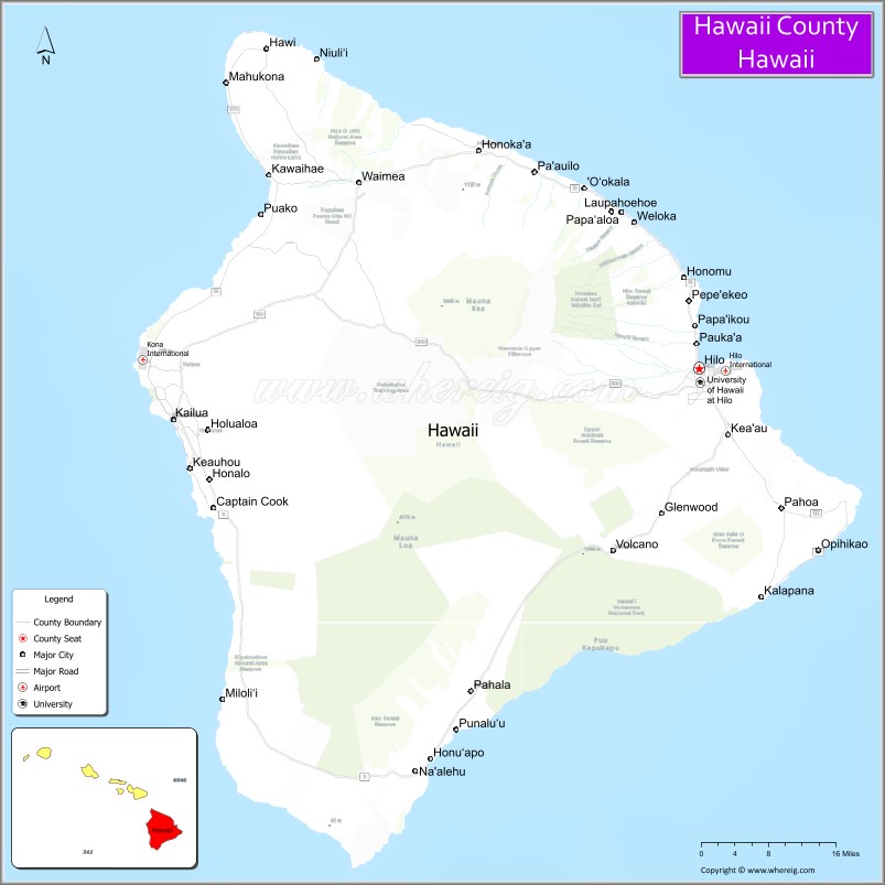
About Hawaii County Map, Alabama: The map showing the county boundary, county seat, major cities, highways, water bodies and neighbouring counties.
Related Hawaii Maps of Info
Map of Hawaii County, Hawaii
Adams County is a county located in the U.S. state of Idaho. It`s county seat is Council. As per 2020 census, the population of Adams County was 4625 and population density of Adams was square miles. According to the United States Census Bureau, the county has a total area of 1,365 sq mi (3,535 km2). Adams County was established on 1911.
Hawaii County Facts
| Continent | North America |
| Country | United States |
| State | Hawaii |
| County Seat | Hilo |
| Largest City/Town | Hilo |
| Established | 1905 |
| Total Area | 5,086 sq mi (13,173 sq km) |
| Land Area | 4,028 sq mi (10,433 sq km) |
| Water Area | 1,058 sq mi (2,740 sq km) |
| Population | 200,629 (Census 2020) |
| Population Density | 50 people per sq mi |
| Time Zone | Hawaii-Aleutian Time Zone (HST) |
| Major Highways | Hawaii Belt Road, Saddle Road (Daniel K. Inouye Highway), Mamalahoa Highway, Queen Kaʻahumanu Highway |
| Major Volcanoes/Rivers | Mauna Loa, Mauna Kea, Kilauea, Wailuku River |
| Neighboring Counties | Maui County, Honolulu County, Kauai County nearby island regions |
| Famous For | Volcanoes National Park, Mauna Kea observatories, black sand beaches, coffee farms, and tropical landscapes |
| Top Attractions | Hawaiʻi Volcanoes National Park, Mauna Kea, Akaka Falls State Park, Punaluʻu Black Sand Beach, Kona Coffee farms |
| Official Website | Official Website |
About Hawaii County, Hawaii
Hawaii County occupies the entire Island of Hawaiʻi, commonly known as the Big Island, and is the largest county in the state of Hawaii. The county seat is Hilo, while Kailua-Kona is the largest population center on the western side of the island. Hawaii County is famous for active volcanoes, diverse climates, world-class astronomy facilities, waterfalls, beaches, coffee farms, and dramatic natural scenery ranging from tropical rainforests to volcanic deserts. ([en.wikipedia.org](https://en.wikipedia.org/wiki/Hawaii_County,_Hawaii?utm_source=chatgpt.com))
Cities and Communities in Hawaii County, Hawaii
| City/Town | Population | Latitude & Longitude |
|---|---|---|
| Hilo (county seat) | 45,000+ | 19.7076°N, 155.0813°W |
| Kailua-Kona | 20,000+ | 19.6390°N, 155.9969°W |
| Waimea | 10,000+ | 20.0200°N, 155.6680°W |
| Pāhoa | 3,000+ | 19.5000°N, 154.9500°W |
| Volcano | 2,500+ | 19.4300°N, 155.2400°W |
| Captain Cook | 3,500+ | 19.4969°N, 155.9214°W |
| Hawi | 1,000+ | 20.2419°N, 155.8286°W |
| Ocean View | 4,000+ | 19.0686°N, 155.7658°W |
Best Golf Courses in Hawaii County, Hawaii
| Golf Course | Location | Latitude & Longitude |
|---|---|---|
| Mauna Kea Golf Course | Kohala Coast | 20.0015°N, 155.8244°W |
| Hualālai Golf Course | Kailua-Kona | 19.8272°N, 155.9921°W |
| Waikoloa Beach Golf Course | Waikoloa | 19.9217°N, 155.7905°W |
| Makani Golf Club | Kailua-Kona Area | 19.7288°N, 155.9682°W |
What are Major Roads and Highways in Hawaii County
Major highways connect communities around the Big Island and provide access to volcanoes, beaches, resorts, and mountain regions.
- Hawaii Belt Road - primary highway circling most of the island
- Saddle Road (Daniel K. Inouye Highway) - major cross-island route between Hilo and Kona
- Mamalahoa Highway - scenic roadway serving western and southern communities
- Queen Kaʻahumanu Highway - coastal highway along the Kona and Kohala coast
Neighboring Counties of Hawaii County
- Maui County (northwest across the Alenuihāhā Channel)
- Honolulu County (northwest island region)
- Kauai County (northwest island region)
What are Top Attractions in Hawaii County, Hawaii
The county offers volcanoes, waterfalls, black sand beaches, astronomy observatories, coffee plantations, hiking trails, and tropical island scenery.
| Main Sight Name | City | Famous For |
|---|---|---|
| Hawaiʻi Volcanoes National Park | Volcano Area | Active volcanoes, lava fields, and hiking trails |
| Mauna Kea | Central Big Island | Summit observatories and stargazing |
| Akaka Falls State Park | Honomu Area | Tropical waterfalls and rainforest scenery |
| Punaluʻu Black Sand Beach | Naʻalehu Area | Black volcanic sand and sea turtles |
| Kona Coffee Farms | Kona Region | World-famous Hawaiian coffee production |
| Rainbow Falls | Hilo | Scenic waterfall and lush gardens |
| Puʻuhonua o Hōnaunau National Historical Park | Captain Cook Area | Ancient Hawaiian cultural heritage |
| Waipiʻo Valley Lookout | Hamakua Coast | Dramatic cliffs and valley landscapes |
| Kealakekua Bay | South Kona | Snorkeling, marine life, and Captain Cook history |
| Hapuna Beach State Recreation Area | Kohala Coast | White sand beach and ocean recreation |
Distance from Hawaii County to Nearby Cities
The following distances are measured by air or inter-island travel routes.
- Hilo to Kailua-Kona - 78 mi (126 km)
- Hilo to Honolulu, Oahu - 216 mi (348 km)
- Hilo to Kahului, Maui - 121 mi (195 km)
- Hilo to Līhuʻe, Kauai - 338 mi (544 km)
- Hilo to Los Angeles, California - 2,476 mi (3,985 km)
- Hilo to San Francisco, California - 2,393 mi (3,851 km)
- Hilo to Seattle, Washington - 2,665 mi (4,289 km)
- Hilo to Tokyo, Japan - 3,859 mi (6,210 km)
- Hilo to Sydney, Australia - 5,078 mi (8,172 km)
- Hilo to Vancouver, Canada - 2,727 mi (4,389 km)
- Hilo to Las Vegas, Nevada - 2,764 mi (4,448 km)
- Hilo to New York City, New York - 4,961 mi (7,984 km)
References
- Hawaii County Official Website
- Hawaii County, Hawaii - Wikipedia
- U.S. Census Bureau QuickFacts
- Hawaiʻi Volcanoes National Park
- Go Hawaii - Big Island
- Alabama Counties
- Alaska boroughs
- Arizona Counties
- Arkansas Counties
- California County Map
- Colorado Counties
- Connecticut Counties
- Delaware Counties
- Florida County Map
- Georgia County Map
- Hawaii Counties
- Idaho Counties
- Illinois Counties
- Indiana Counties
- Iowa Counties
- Kansas Counties
- Kentucky Counties
- Louisiana Counties
- Maine Counties
- Maryland Counties
- Massachusetts Counties
- Michigan County Map
- Minnesota Counties
- Mississippi Counties
- Missouri Counties
- Montana Counties
- Nebraska Counties
- Nevada Counties
- New York Counties
- New Hampshire Counties
- New Jersey Counties
- New Mexico Counties
- North Carolina Counties
- North Dakota Counties
- Ohio County Map
- Oklahoma Counties
- Oregon Counties
- Pennsylvania Counties
- Rhode Island Counties
- South Carolina Counties
- South Dakota Counties
- Map of Tennessee
- Texas County Map
- Utah Counties
- Vermont Counties
- Virginia Counties
- Washington Counties
- West Virginia Counties
- Wisconsin Counties
- Wyoming Counties