Map of Kauai County - Kauai County is a county located in the U.S. state of Hawaii. Kauai County Map showing cities, highways, important places and water bodies. Get Where is Kauai County located in the map, major cities in Kauai county, population, areas, and places of interest.
Kauai County Map, Hawaii
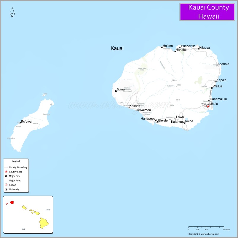
About Kauai County Map, Alabama: The map showing the county boundary, county seat, major cities, highways, water bodies and neighbouring counties.
Related Hawaii Maps of Info
Map of Kauai County, Hawaii
Benewah County is a county located in the U.S. state of Idaho. It`s county seat is St. Maries. As per 2020 census, the population of Benewah County was 9931 and population density of Benewah was square miles. According to the United States Census Bureau, the county has a total area of 776 sq mi (2,010 km2). Benewah County was established on 1915.
Kauai County Facts
| Continent | North America |
| Country | United States |
| State | Hawaii |
| County Seat | Līhuʻe |
| Largest City/Town | Kapaʻa |
| Established | 1905 |
| Total Area | 1,266 sq mi (3,279 sq km) |
| Land Area | 620 sq mi (1,606 sq km) |
| Water Area | 646 sq mi (1,673 sq km) |
| Population | 73,298 (Census 2020) |
| Population Density | 118 people per sq mi |
| Time Zone | Hawaii-Aleutian Time Zone (HST) |
| Major Highways | Kaumualiʻi Highway, Kūhiō Highway, Māmalahoa Highway |
| Major Water Bodies | Pacific Ocean, Wailua River |
| Neighboring Counties | Honolulu County, Maui County, Hawaii County nearby island regions |
| Famous For | Na Pali Coast, Waimea Canyon, tropical rainforests, waterfalls, and scenic beaches |
| Top Attractions | Na Pali Coast State Wilderness Park, Waimea Canyon State Park, Wailua Falls, Hanalei Bay, Poipu Beach |
| Official Website | Official Website |
About Kauai County, Hawaii
Kauai County encompasses the islands of Kauaʻi, Niʻihau, Kaʻula, and nearby smaller islands in northwestern Hawaii. The county seat is Līhuʻe, while Kapaʻa is the largest population center. Kauai County is widely known as the “Garden Isle” because of its lush tropical landscapes, dramatic cliffs, waterfalls, beaches, rainforests, and scenic outdoor recreation areas. ([en.wikipedia.org](https://en.wikipedia.org/wiki/Kauai_County,_Hawaii?utm_source=chatgpt.com))
Cities and Communities in Kauai County, Hawaii
| City/Town | Population | Latitude & Longitude |
|---|---|---|
| Līhuʻe (county seat) | 8,000+ | 21.9747°N, 159.3656°W |
| Kapaʻa | 11,000+ | 22.0889°N, 159.3190°W |
| Princeville | 2,000+ | 22.2208°N, 159.4968°W |
| Hanalei | 500+ | 22.2038°N, 159.5037°W |
| Poʻipū | 1,000+ | 21.8764°N, 159.4569°W |
| Waimea | 2,000+ | 21.9581°N, 159.6699°W |
| Koloa | 2,500+ | 21.9075°N, 159.4656°W |
| Hanapēpē | 2,000+ | 21.9103°N, 159.5890°W |
Best Golf Courses in Kauai County, Hawaii
| Golf Course | Location | Latitude & Longitude |
|---|---|---|
| Princeville Makai Golf Club | Princeville | 22.2238°N, 159.4898°W |
| Poipu Bay Golf Course | Poʻipū | 21.8710°N, 159.4385°W |
| Ocean Course at Hokuala | Līhuʻe | 21.9632°N, 159.3374°W |
| Kukuiolono Golf Course | Kalaheo | 21.9248°N, 159.5264°W |
What are Major Roads and Highways in Kauai County
Major highways provide transportation across Kauaʻi and connect resort areas, beaches, mountain parks, and local communities.
- Kaumualiʻi Highway - primary highway connecting western and southern Kauaʻi communities
- Kūhiō Highway - scenic coastal roadway serving eastern and northern regions
- Māmalahoa Highway - regional connector route through central areas
- Local Coastal Roads - scenic routes linking beaches, parks, and resort destinations
Neighboring Counties of Kauai County
- Honolulu County (southeast across island channels)
- Maui County (southeast island region)
- Hawaii County (southeast island region)
What are Top Attractions in Kauai County, Hawaii
The county offers tropical beaches, waterfalls, hiking trails, dramatic cliffs, river adventures, and some of Hawaii’s most scenic natural landscapes.
| Main Sight Name | City | Famous For |
|---|---|---|
| Na Pali Coast State Wilderness Park | Northwest Kauaʻi | Sea cliffs, hiking, and boat tours |
| Waimea Canyon State Park | Waimea Area | “Grand Canyon of the Pacific” scenic views |
| Wailua Falls | Līhuʻe Area | Twin waterfalls and tropical rainforest scenery |
| Hanalei Bay | Hanalei | Surfing, beaches, and mountain landscapes |
| Poipu Beach | Poʻipū | Snorkeling, sea turtles, and family recreation |
| Wailua River | East Kauaʻi | Kayaking and riverboat adventures |
| Spouting Horn | Koloa Area | Ocean blowhole and coastal scenery |
| Kilauea Lighthouse | Kilauea | Wildlife refuge and panoramic ocean views |
| Kalalau Trail | Na Pali Coast | Famous hiking route and wilderness scenery |
| Fern Grotto | Wailua River Area | Natural lava cave and tropical vegetation |
Distance from Kauai County to Nearby Cities
The following distances are measured by air or inter-island travel routes.
- Līhuʻe to Honolulu, Oahu - 108 mi (174 km)
- Līhuʻe to Kahului, Maui - 201 mi (323 km)
- Līhuʻe to Hilo, Hawaii - 338 mi (544 km)
- Līhuʻe to Kailua-Kona, Hawaii - 290 mi (467 km)
- Līhuʻe to Los Angeles, California - 2,613 mi (4,205 km)
- Līhuʻe to San Francisco, California - 2,453 mi (3,948 km)
- Līhuʻe to Seattle, Washington - 2,736 mi (4,403 km)
- Līhuʻe to Tokyo, Japan - 3,745 mi (6,027 km)
- Līhuʻe to Sydney, Australia - 5,112 mi (8,227 km)
- Līhuʻe to Vancouver, Canada - 2,767 mi (4,453 km)
- Līhuʻe to Las Vegas, Nevada - 2,817 mi (4,534 km)
- Līhuʻe to New York City, New York - 5,037 mi (8,106 km)
References
- Kauai County Official Website
- Kauai County, Hawaii - Wikipedia
- U.S. Census Bureau QuickFacts
- Waimea Canyon State Park
- Go Hawaii - Kauai
- Alabama Counties
- Alaska boroughs
- Arizona Counties
- Arkansas Counties
- California County Map
- Colorado Counties
- Connecticut Counties
- Delaware Counties
- Florida County Map
- Georgia County Map
- Hawaii Counties
- Idaho Counties
- Illinois Counties
- Indiana Counties
- Iowa Counties
- Kansas Counties
- Kentucky Counties
- Louisiana Counties
- Maine Counties
- Maryland Counties
- Massachusetts Counties
- Michigan County Map
- Minnesota Counties
- Mississippi Counties
- Missouri Counties
- Montana Counties
- Nebraska Counties
- Nevada Counties
- New York Counties
- New Hampshire Counties
- New Jersey Counties
- New Mexico Counties
- North Carolina Counties
- North Dakota Counties
- Ohio County Map
- Oklahoma Counties
- Oregon Counties
- Pennsylvania Counties
- Rhode Island Counties
- South Carolina Counties
- South Dakota Counties
- Map of Tennessee
- Texas County Map
- Utah Counties
- Vermont Counties
- Virginia Counties
- Washington Counties
- West Virginia Counties
- Wisconsin Counties
- Wyoming Counties