Map of Maui County - Maui County is a county located in the U.S. state of Hawaii. Maui County Map showing cities, highways, important places and water bodies. Get Where is Maui County located in the map, major cities in Maui county, population, areas, and places of interest.
Maui County Map, Hawaii
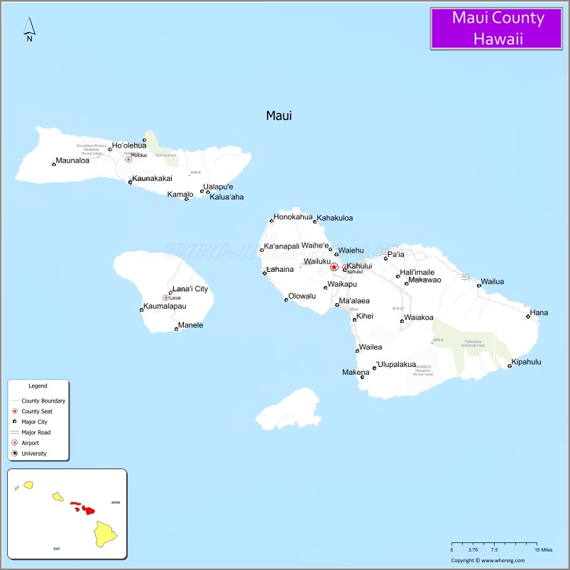
About Maui County County Map, Hawaii: The map showing the county boundary, county seat, major cities, highways, water bodies and neighbouring counties.
Related Hawaii Maps of Info
Map of Maui County, Hawaii
Bingham County is a county located in the U.S. state of Idaho. It`s county seat is Blackfoot. As per 2020 census, the population of Bingham County was 48876 and population density of Bingham was square miles. According to the United States Census Bureau, the county has a total area of 2,095 sq mi (5,426 km2). Bingham County was established on 1885.
Maui County Facts
| Continent | North America |
| Country | United States |
| State | Hawaii |
| County Seat | Wailuku |
| Largest City/Town | Kahului |
| Established | 1905 |
| Total Area | 2,398 sq mi (6,211 sq km) |
| Land Area | 1,162 sq mi (3,009 sq km) |
| Water Area | 1,236 sq mi (3,202 sq km) |
| Population | 164,754 (Census 2020) |
| Population Density | 142 people per sq mi |
| Time Zone | Hawaii-Aleutian Time Zone (HST) |
| Major Highways | Hāna Highway, Honoapiʻilani Highway, Haleakalā Highway, Piʻilani Highway |
| Major Water Bodies | Pacific Ocean, ʻĪao Stream |
| Neighboring Counties | Honolulu County, Hawaii County, Kauai County nearby island regions |
| Famous For | Road to Hāna, Haleakalā volcano, luxury resorts, whale watching, and tropical beaches |
| Top Attractions | Haleakalā National Park, Road to Hāna, Kāʻanapali Beach, ʻĪao Valley State Monument, Molokini Crater |
| Official Website | Official Website |
About Maui County, Hawaii
Maui County includes the islands of Maui, Molokaʻi (except Kalawao County), Lānaʻi, Kahoʻolawe, and smaller surrounding islands. The county seat is Wailuku, while Kahului is the largest commercial center. Maui County is internationally known for volcanic landscapes, tropical beaches, luxury resorts, whale watching, scenic coastal drives, and Hawaiian cultural heritage. ([en.wikipedia.org](https://en.wikipedia.org/wiki/Maui_County,_Hawaii?utm_source=chatgpt.com))
Cities and Communities in Maui County, Hawaii
| City/Town | Population | Latitude & Longitude |
|---|---|---|
| Kahului | 28,000+ | 20.8895°N, 156.4729°W |
| Wailuku (county seat) | 17,000+ | 20.8913°N, 156.5047°W |
| Lahaina | 13,000+ | 20.8783°N, 156.6825°W |
| Kīhei | 22,000+ | 20.7850°N, 156.4656°W |
| Makawao | 7,000+ | 20.8569°N, 156.3131°W |
| Hāna | 1,500+ | 20.7570°N, 155.9884°W |
| Lānaʻi City | 3,000+ | 20.8272°N, 156.9197°W |
| Kaunakakai | 3,500+ | 21.0933°N, 157.0236°W |
Best Golf Courses in Maui County, Hawaii
| Golf Course | Location | Latitude & Longitude |
|---|---|---|
| Kapalua Plantation Course | Kapalua | 21.0031°N, 156.6648°W |
| Wailea Golf Club | Wailea | 20.6848°N, 156.4419°W |
| Maui Nui Golf Club | Kīhei | 20.7462°N, 156.4476°W |
| The Dunes at Maui Lani | Kahului | 20.8872°N, 156.4648°W |
What are Major Roads and Highways in Maui County
Major highways connect Maui County communities, beaches, volcano regions, and tourism destinations across the islands.
- Hāna Highway - world-famous scenic coastal route with waterfalls and rainforest views
- Honoapiʻilani Highway - major roadway serving western Maui resort communities
- Haleakalā Highway - mountain route leading to Haleakalā National Park
- Piʻilani Highway - southern Maui coastal connector road
Neighboring Counties of Maui County
- Honolulu County (west across island channels)
- Hawaii County (southeast across the Alenuihāhā Channel)
- Kauai County (northwest island region)
What are Top Attractions in Maui County, Hawaii
The county offers volcanic landscapes, beaches, waterfalls, snorkeling, whale watching, scenic drives, and luxury island tourism experiences.
| Main Sight Name | City | Famous For |
|---|---|---|
| Haleakalā National Park | Upcountry Maui | Volcanic summit, sunrise views, and hiking trails |
| Road to Hāna | East Maui | Scenic coastal drive with waterfalls and rainforests |
| Kāʻanapali Beach | Lahaina Area | Resorts, snorkeling, and ocean recreation |
| ʻĪao Valley State Monument | Wailuku | Lush valley scenery and the ʻĪao Needle |
| Molokini Crater | South Maui | Snorkeling, diving, and marine wildlife |
| Wailea Beach Resorts | Wailea | Luxury accommodations and tropical beaches |
| Lāhainā Historic District | Lahaina | Historic whaling town and cultural heritage |
| Makena Beach | South Maui | Golden sand beach and scenic coastline |
| Whale Watching Areas | Maui Waters | Seasonal humpback whale viewing tours |
| Hoʻokipa Beach Park | Paia Area | Surfing, windsurfing, and sea turtle viewing |
Distance from Maui County to Nearby Cities
The following distances are measured by air or inter-island travel routes.
- Kahului to Honolulu, Oahu - 101 mi (163 km)
- Kahului to Hilo, Hawaii - 121 mi (195 km)
- Kahului to Kailua-Kona, Hawaii - 84 mi (135 km)
- Kahului to Līhuʻe, Kauai - 201 mi (323 km)
- Kahului to Los Angeles, California - 2,487 mi (4,003 km)
- Kahului to San Francisco, California - 2,328 mi (3,746 km)
- Kahului to Seattle, Washington - 2,607 mi (4,196 km)
- Kahului to Tokyo, Japan - 3,780 mi (6,083 km)
- Kahului to Sydney, Australia - 5,028 mi (8,092 km)
- Kahului to Vancouver, Canada - 2,638 mi (4,245 km)
- Kahului to Las Vegas, Nevada - 2,692 mi (4,332 km)
- Kahului to New York City, New York - 4,913 mi (7,907 km)
References
- Maui County Official Website
- Maui County, Hawaii - Wikipedia
- U.S. Census Bureau QuickFacts
- Haleakalā National Park
- Go Hawaii - Maui
- Alabama Counties
- Alaska boroughs
- Arizona Counties
- Arkansas Counties
- California County Map
- Colorado Counties
- Connecticut Counties
- Delaware Counties
- Florida County Map
- Georgia County Map
- Hawaii Counties
- Idaho Counties
- Illinois Counties
- Indiana Counties
- Iowa Counties
- Kansas Counties
- Kentucky Counties
- Louisiana Counties
- Maine Counties
- Maryland Counties
- Massachusetts Counties
- Michigan County Map
- Minnesota Counties
- Mississippi Counties
- Missouri Counties
- Montana Counties
- Nebraska Counties
- Nevada Counties
- New York Counties
- New Hampshire Counties
- New Jersey Counties
- New Mexico Counties
- North Carolina Counties
- North Dakota Counties
- Ohio County Map
- Oklahoma Counties
- Oregon Counties
- Pennsylvania Counties
- Rhode Island Counties
- South Carolina Counties
- South Dakota Counties
- Map of Tennessee
- Texas County Map
- Utah Counties
- Vermont Counties
- Virginia Counties
- Washington Counties
- West Virginia Counties
- Wisconsin Counties
- Wyoming Counties