Written and Fact-checked by Whereig Editors | Updated On: May 31, 2026
Map of Washington County - Washington County is a county located in the U.S. state of Rhode Island. Washington County Map showing cities, highways, important places and water bodies. Get Where is Washington County located in the map, major cities in Washington county, population, areas, and places of interest.
Map of Washington County, Rhode Island
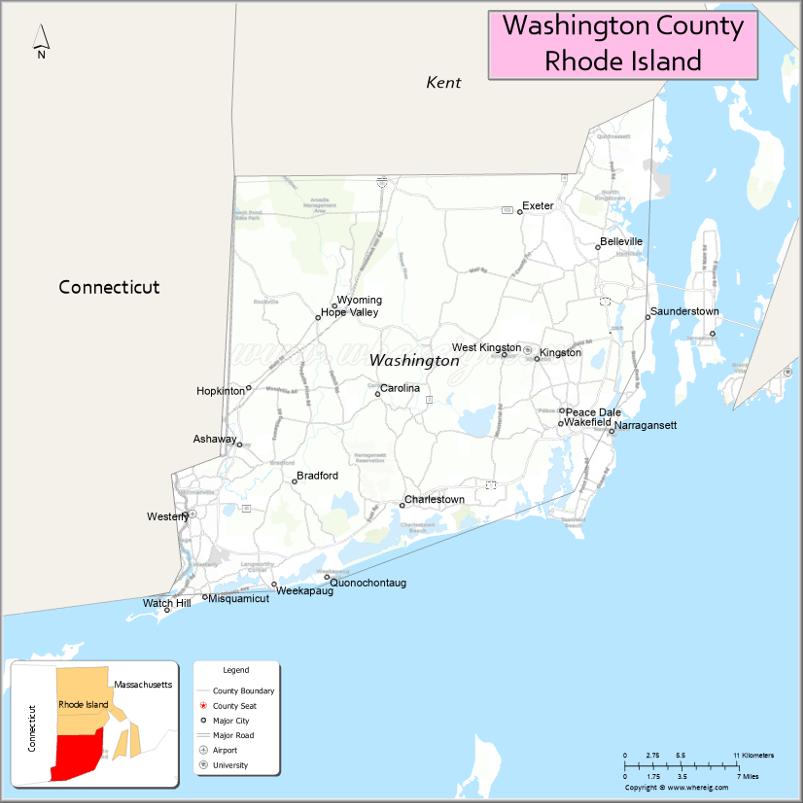
About Washington County Map, Rhode Island: The map showing the county boundary, county seat, major cities, highways, water bodies and neighbouring counties.
More Rhode Island Maps & Info
About Washington County, Rhode Island
Washington County is a county located in the U.S. state of Rhode Island. It's county seat is South Kingstown*. As per 2020 census, the population of Washington County is 130592 people and population density is square miles. According to the United States Census Bureau, the county has a total area of 329 sq mi (852 km2). Washington County was established on 1729.
Washington County Facts
| Continent | North America |
| Country | United States |
| State | Rhode Island |
| County Seat | South Kingstown |
| Largest City/Town | South Kingstown |
| Established | 1729 |
| Total Area | 563.8 sq mi (1,460.2 sq km) |
| Land Area | 329.7 sq mi (854.0 sq km) |
| Water Area | 234.1 sq mi (606.2 sq km) |
| Population | 129,839 (Census 2020) |
| Population Density | 393.8 people per sq mi |
| Time Zone | Eastern Time Zone |
| Major Highways | Interstate 95, US Route 1, Rhode Island Route 2, Rhode Island Route 4, Rhode Island Route 138 |
| Major Rivers | Pawcatuck River, Wood River, Queen River, Chipuxet River |
| Neighboring Counties | Kent County (Rhode Island), Newport County (Rhode Island), Providence County (Rhode Island), New London County (Connecticut) |
| Famous For | Narragansett Beach, Block Island, University of Rhode Island, coastal villages, and wildlife refuges |
| Top Attractions | Block Island, Narragansett Town Beach, Point Judith, Ninigret National Wildlife Refuge, and South County coastline |
| Official Website | Official Website |
About Washington County, Rhode Island
Washington County is located in southern Rhode Island and was established in 1729. The county seat and largest town is South Kingstown. Often referred to as South County, it is known for its Atlantic Ocean coastline, beaches, historic villages, wildlife refuges, and outdoor recreation. The county is also home to the University of Rhode Island and the popular resort destination of Block Island.
Cities and Towns in Washington County, Rhode Island
| City/Town | Population (Census 2020) | Latitude & Longitude |
|---|---|---|
| South Kingstown (county seat) | 31,931 | 41.4548°N, 71.5617°W |
| Narragansett | 14,532 | 41.4501°N, 71.4495°W |
| North Kingstown | 27,732 | 41.5501°N, 71.4662°W |
| Westerly | 23,359 | 41.3776°N, 71.8273°W |
| Charlestown | 8,529 | 41.3834°N, 71.6415°W |
| Richmond | 8,020 | 41.4901°N, 71.6631°W |
| Hopkinton | 8,402 | 41.4612°N, 71.7773°W |
| Exeter | 6,460 | 41.5770°N, 71.5378°W |
| New Shoreham (Block Island) | 1,410 | 41.1701°N, 71.5587°W |
| Wakefield-Peacedale (CDP) | 9,869 | 41.4370°N, 71.5001°W |
| Kingston (CDP) | 7,825 | 41.4801°N, 71.5228°W |
| Bradford (CDP) | 1,769 | 41.3995°N, 71.7470°W |
Best Golf Courses in Washington County, Rhode Island
| Golf Course | Location | Latitude & Longitude |
|---|---|---|
| Triggs Memorial Extension Course | North Kingstown | 41.5731°N, 71.4827°W |
| North Kingstown Golf Course | North Kingstown | 41.5753°N, 71.4768°W |
| Meadow Brook Golf Course | Richmond | 41.4682°N, 71.7056°W |
| Laurel Lane Country Club | West Kingston | 41.4820°N, 71.5914°W |
| Fenner Hill Golf Club | Hope Valley | 41.5104°N, 71.7396°W |
| Shelter Harbor Golf Club | Charlestown | 41.3486°N, 71.6402°W |
| Winnapaug Country Club | Westerly | 41.3208°N, 71.8206°W |
| Weekapaug Golf Club | Westerly | 41.3287°N, 71.8044°W |
| Montauk Golf Range | Narragansett | 41.4396°N, 71.4679°W |
What are Major Roads and Highways in Washington County
Major highways connect the county to nearby regions and cities.
- Interstate 95 - major north-south interstate connecting the county with Providence, Connecticut, New York, and Boston
- US Route 1 - scenic coastal route serving Narragansett, South Kingstown, Charlestown, and Westerly
- Rhode Island Route 2 - regional highway linking South County communities
- Rhode Island Route 4 - expressway connecting North Kingstown with Providence metropolitan areas
- Rhode Island Route 138 - major east-west route connecting Jamestown, North Kingstown, and South Kingstown
Neighboring Counties of Washington County
- Kent County (north)
- Providence County (northwest)
- Newport County (east across Narragansett Bay)
- New London County, Connecticut (west)
What are Top Attractions in Washington County, Rhode Island
The county offers a mix of natural and cultural attractions.
| Main Sight Name | City | Famous For |
|---|---|---|
| Block Island | New Shoreham | Beaches, bluffs, lighthouses, and outdoor recreation |
| Narragansett Town Beach | Narragansett | One of Rhode Island's most popular beaches |
| Point Judith Lighthouse | Narragansett | Historic lighthouse and coastal views |
| Ninigret National Wildlife Refuge | Charlestown | Birdwatching, trails, and wildlife habitat |
| East Matunuck State Beach | South Kingstown | Oceanfront swimming and surfing |
| University of Rhode Island | Kingston | State flagship university campus |
| Misquamicut State Beach | Westerly | Popular Atlantic Ocean beach destination |
| Watch Hill | Westerly | Historic coastal village and harbor |
| Sachuest Point National Wildlife Refuge | Middletown Area | Wildlife observation and coastal trails |
| Trustom Pond National Wildlife Refuge | South Kingstown | Protected coastal pond and bird habitat |
| Beavertail State Park Views | Narragansett Bay Area | Scenic ocean panoramas |
| South County Museum | Narragansett | Regional history and cultural exhibits |
| Burlingame State Park | Charlestown | Camping, hiking, and outdoor recreation |
| Arcadia Management Area | Exeter | Large forest preserve with trails and fishing |
| Frosty Drew Observatory | Charlestown | Astronomy programs and stargazing |
Distance from Washington County to Nearby Cities
The following distances are measured by road (driving).
- South Kingstown to Narragansett (Washington County), Rhode Island - 5 mi (8 km)
- South Kingstown to North Kingstown (Washington County), Rhode Island - 11 mi (18 km)
- South Kingstown to Charlestown (Washington County), Rhode Island - 12 mi (19 km)
- South Kingstown to Westerly (Washington County), Rhode Island - 19 mi (31 km)
- South Kingstown to Richmond (Washington County), Rhode Island - 10 mi (16 km)
- South Kingstown to East Greenwich (Kent County), Rhode Island - 18 mi (29 km)
- South Kingstown to Warwick (Kent County), Rhode Island - 23 mi (37 km)
- South Kingstown to Newport (Newport County), Rhode Island - 27 mi (43 km)
- South Kingstown to Providence (Providence County), Rhode Island - 31 mi (50 km)
- South Kingstown to Bristol (Bristol County), Rhode Island - 33 mi (53 km)
- South Kingstown to New London (New London County), Connecticut - 37 mi (60 km)
- South Kingstown to Norwich (New London County), Connecticut - 34 mi (55 km)
- South Kingstown to Hartford (Hartford County), Connecticut - 68 mi (109 km)
- South Kingstown to Worcester (Worcester County), Massachusetts - 76 mi (122 km)
- South Kingstown to Boston (Suffolk County), Massachusetts - 78 mi (126 km)
References
- QuickFacts - Washington County, Rhode Island
- United States Census Bureau
- United States Geological Survey (USGS)
- National Geodetic Survey
- South County Rhode Island Tourism Council
- Alabama Counties
- Alaska boroughs
- Arizona Counties
- Arkansas Counties
- California County Map
- Colorado Counties
- Connecticut Counties
- Delaware Counties
- Florida County Map
- Georgia County Map
- Hawaii Counties
- Idaho Counties
- Illinois Counties
- Indiana Counties
- Iowa Counties
- Kansas Counties
- Kentucky Counties
- Louisiana Counties
- Maine Counties
- Maryland Counties
- Massachusetts Counties
- Michigan County Map
- Minnesota Counties
- Mississippi Counties
- Missouri Counties
- Montana Counties
- Nebraska Counties
- Nevada Counties
- New York Counties
- New Hampshire Counties
- New Jersey Counties
- New Mexico Counties
- North Carolina Counties
- North Dakota Counties
- Ohio County Map
- Oklahoma Counties
- Oregon Counties
- Pennsylvania Counties
- Rhode Island Counties
- South Carolina Counties
- South Dakota Counties
- Map of Tennessee
- Texas County Map
- Utah Counties
- Vermont Counties
- Virginia Counties
- Washington Counties
- West Virginia Counties
- Wisconsin Counties
- Wyoming Counties