Written and Fact-checked by Whereig Editors | Updated On: May 31, 2026
Map of Bristol County - Bristol County is a county located in the U.S. state of Rhode Island. Bristol County Map showing cities, highways, important places and water bodies. Get Where is Bristol County located in the map, major cities in Bristol county, population, areas, and places of interest.
Map of Bristol County, Rhode Island
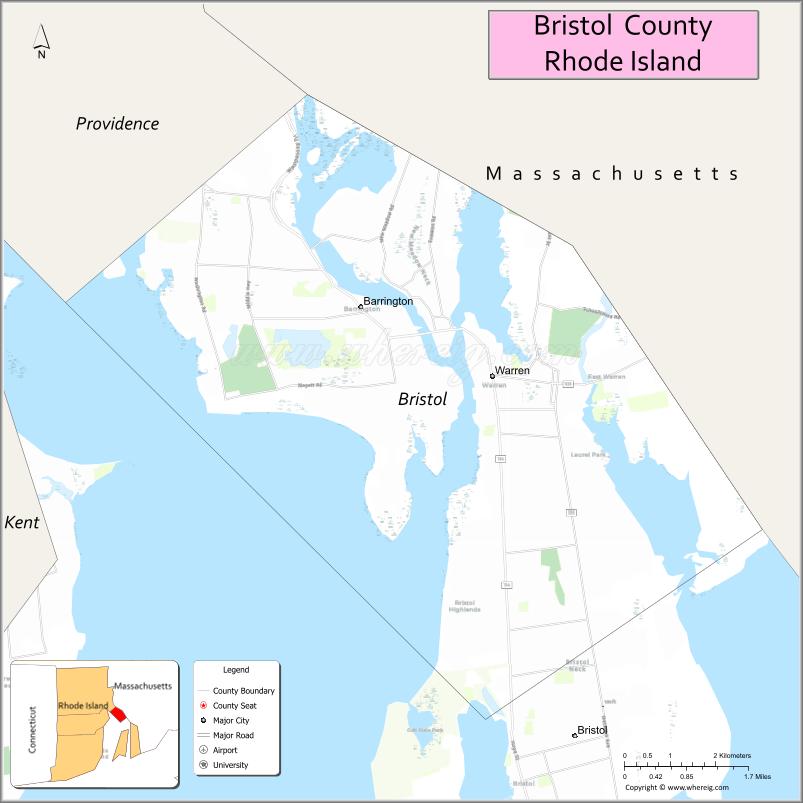
About Bristol County Map, Rhode Island: The map showing the county boundary, county seat, major cities, highways, water bodies and neighbouring counties.
More Rhode Island Maps & Info
About Bristol County, Rhode Island
Bristol County is a county located in the U.S. state of Rhode Island. It's county seat is Bristol. As per 2020 census, the population of Bristol County is 50818 people and population density is square miles. According to the United States Census Bureau, the county has a total area of 24 sq mi (62 km2). Bristol County was established on 1747.
Bristol County Facts
| Continent | North America |
| Country | United States |
| State | Rhode Island |
| County Seat | Bristol |
| Largest City/Town | Bristol |
| Established | 1747 |
| Total Area | 45.2 sq mi (117.1 sq km) |
| Land Area | 24.9 sq mi (64.5 sq km) |
| Water Area | 20.3 sq mi (52.6 sq km) |
| Population | 50,158 (Census 2020) |
| Population Density | 2,014.4 people per sq mi |
| Time Zone | Eastern Time Zone |
| Major Highways | US Route 6, Rhode Island Route 114, Rhode Island Route 136 |
| Major Rivers | Palmer River, Kickemuit River, Warren River |
| Neighboring Counties | Kent County (Rhode Island), Newport County (Rhode Island), Providence County (Rhode Island), Bristol County (Massachusetts) |
| Famous For | America's oldest continuous Fourth of July celebration, Colt State Park, waterfront communities, and maritime history |
| Top Attractions | Colt State Park, Blithewold Mansion, East Bay Bike Path, Herreshoff Marine Museum, and Independence Park |
| Official Website | Official Website |
About Bristol County, Rhode Island
Bristol County is located in the eastern part of Rhode Island and was established in 1747. The county seat and largest town is Bristol. Situated along Narragansett Bay, the county is known for its coastal scenery, maritime heritage, historic architecture, and recreational waterfront areas. Despite being Rhode Island's smallest county by land area, it is one of the state's most historically significant regions.
Cities and Towns in Bristol County, Rhode Island
| City/Town | Population (Census 2020) | Latitude & Longitude |
|---|---|---|
| Bristol (county seat) | 22,493 | 41.6770°N, 71.2662°W |
| Barrington | 17,153 | 41.7407°N, 71.3087°W |
| Warren | 10,512 | 41.7307°N, 71.2820°W |
Best Golf Courses in Bristol County, Rhode Island
| Golf Course | Location | Latitude & Longitude |
|---|---|---|
| Bristol Golf Club | Bristol | 41.6827°N, 71.2778°W |
| Rhode Island Country Club | Barrington | 41.7335°N, 71.3196°W |
| Touisset Country Club | Warren | 41.7024°N, 71.2405°W |
What are Major Roads and Highways in Bristol County
Major highways connect the county to nearby regions and cities.
- US Route 6 - connects Barrington with Providence and southeastern Massachusetts
- Rhode Island Route 114 - major north-south route linking Barrington, Warren, Bristol, and Newport County
- Rhode Island Route 136 - connects Bristol with Massachusetts communities to the east
- Local roads provide access to waterfront districts, parks, and residential neighborhoods
Neighboring Counties of Bristol County
- Providence County, Rhode Island (north)
- Kent County, Rhode Island (west)
- Newport County, Rhode Island (south across Narragansett Bay)
- Bristol County, Massachusetts (east)
What are Top Attractions in Bristol County, Rhode Island
The county offers a mix of natural and cultural attractions.
| Main Sight Name | City | Famous For |
|---|---|---|
| Colt State Park | Bristol | Waterfront recreation, walking trails, and scenic views of Narragansett Bay |
| Blithewold Mansion, Gardens & Arboretum | Bristol | Historic mansion and nationally recognized gardens |
| Herreshoff Marine Museum | Bristol | America's Cup yacht history and maritime heritage |
| Independence Park | Bristol | Waterfront park and center of Fourth of July celebrations |
| East Bay Bike Path | Bristol | Popular cycling and walking trail along the shoreline |
| Warren Waterfront Historic District | Warren | Historic architecture, shops, and restaurants |
| Touisset Marsh Wildlife Refuge | Warren | Birdwatching and coastal habitat |
| Haines Memorial State Park | Barrington | Picnicking, waterfront access, and recreation |
| Barrington Beach | Barrington | Swimming and coastal recreation |
| Coggeshall Farm Museum | Bristol | Living history farm depicting 18th-century life |
Distance from Bristol County to Nearby Cities
The following distances are measured by road (driving).
- Bristol to Warren (Bristol County), Rhode Island - 4 mi (6 km)
- Bristol to Barrington (Bristol County), Rhode Island - 8 mi (13 km)
- Bristol to East Providence (Providence County), Rhode Island - 11 mi (18 km)
- Bristol to Providence (Providence County), Rhode Island - 16 mi (26 km)
- Bristol to Newport (Newport County), Rhode Island - 20 mi (32 km)
- Bristol to Warwick (Kent County), Rhode Island - 18 mi (29 km)
- Bristol to Cranston (Providence County), Rhode Island - 19 mi (31 km)
- Bristol to Fall River (Bristol County), Massachusetts - 13 mi (21 km)
- Bristol to New Bedford (Bristol County), Massachusetts - 24 mi (39 km)
- Bristol to Taunton (Bristol County), Massachusetts - 28 mi (45 km)
- Bristol to Attleboro (Bristol County), Massachusetts - 27 mi (43 km)
- Bristol to Woonsocket (Providence County), Rhode Island - 32 mi (51 km)
- Bristol to Narragansett (Washington County), Rhode Island - 30 mi (48 km)
- Bristol to Boston (Suffolk County), Massachusetts - 69 mi (111 km)
- Bristol to Hartford (Hartford County), Connecticut - 87 mi (140 km)
References
- QuickFacts - Bristol County, Rhode Island
- United States Census Bureau
- United States Geological Survey (USGS)
- National Geodetic Survey
- Official Website
- Alabama Counties
- Alaska boroughs
- Arizona Counties
- Arkansas Counties
- California County Map
- Colorado Counties
- Connecticut Counties
- Delaware Counties
- Florida County Map
- Georgia County Map
- Hawaii Counties
- Idaho Counties
- Illinois Counties
- Indiana Counties
- Iowa Counties
- Kansas Counties
- Kentucky Counties
- Louisiana Counties
- Maine Counties
- Maryland Counties
- Massachusetts Counties
- Michigan County Map
- Minnesota Counties
- Mississippi Counties
- Missouri Counties
- Montana Counties
- Nebraska Counties
- Nevada Counties
- New York Counties
- New Hampshire Counties
- New Jersey Counties
- New Mexico Counties
- North Carolina Counties
- North Dakota Counties
- Ohio County Map
- Oklahoma Counties
- Oregon Counties
- Pennsylvania Counties
- Rhode Island Counties
- South Carolina Counties
- South Dakota Counties
- Map of Tennessee
- Texas County Map
- Utah Counties
- Vermont Counties
- Virginia Counties
- Washington Counties
- West Virginia Counties
- Wisconsin Counties
- Wyoming Counties