Written and Fact-checked by Whereig Editors | Updated On: May 31, 2026
Map of Kent County - Kent County is a county located in the U.S. state of Rhode Island. Kent County Map showing cities, highways, important places and water bodies. Get Where is Kent County located in the map, major cities in Kent county, population, areas, and places of interest.
Map of Kent County, Rhode Island
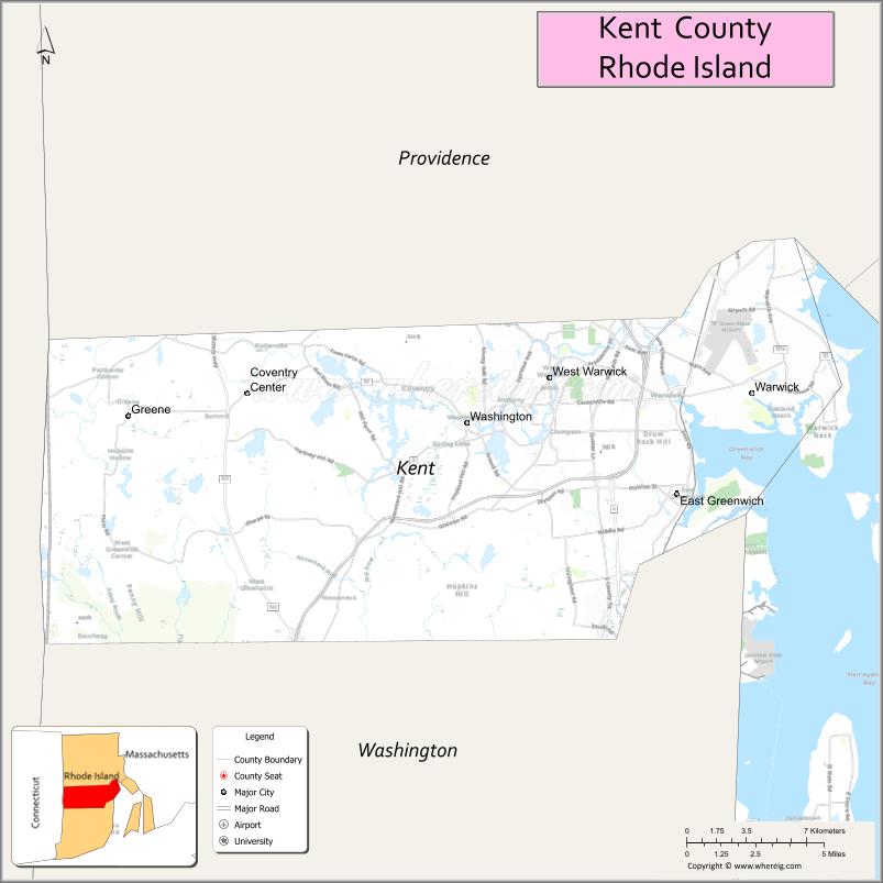
About Kent County Map, Rhode Island: The map showing the county boundary, county seat, major cities, highways, water bodies and neighbouring counties.
More Rhode Island Maps & Info
About Kent County, Rhode Island
Kent County is a county located in the U.S. state of Rhode Island. It's county seat is East Greenwich. As per 2020 census, the population of Kent County is 170715 people and population density is square miles. According to the United States Census Bureau, the county has a total area of 168 sq mi (435 km2). Kent County was established on 1750.
Kent County Facts
| Continent | North America |
| Country | United States |
| State | Rhode Island |
| County Seat | East Greenwich |
| Largest City/Town | Warwick |
| Established | 1750 |
| Total Area | 188.9 sq mi (489.3 sq km) |
| Land Area | 168.4 sq mi (436.2 sq km) |
| Water Area | 20.5 sq mi (53.1 sq km) |
| Population | 170,363 (Census 2020) |
| Population Density | 1,011.7 people per sq mi |
| Time Zone | Eastern Time Zone |
| Major Highways | Interstate 95, Interstate 295, Rhode Island Route 4, US Route 1 |
| Major Rivers | Pawtuxet River, Flat River, South Branch Pawtuxet River |
| Neighboring Counties | Providence County, Bristol County, Washington County, Newport County |
| Famous For | T.F. Green International Airport, Warwick, Goddard Memorial State Park, historic East Greenwich, and Narragansett Bay shoreline |
| Top Attractions | Goddard Memorial State Park, Warwick City Park, Clouds Hill Museum, East Greenwich Waterfront, and Oakland Beach |
| Official Website | Official Website |
About Kent County, Rhode Island
Kent County is located in central Rhode Island and was established in 1750. The county seat is East Greenwich, while Warwick is the largest city. The county borders Narragansett Bay and serves as a major residential, commercial, and transportation hub for the state. Kent County is home to Rhode Island T.F. Green International Airport and features a blend of historic communities, coastal recreation, and modern development.
Cities and Towns in Kent County, Rhode Island
| City/Town | Population (Census 2020) | Latitude & Longitude |
|---|---|---|
| East Greenwich (county seat) | 14,223 | 41.6604°N, 71.4484°W |
| Warwick | 82,823 | 41.7001°N, 71.4162°W |
| West Warwick | 31,425 | 41.6965°N, 71.5217°W |
| Coventry | 35,688 | 41.7001°N, 71.6828°W |
Best Golf Courses in Kent County, Rhode Island
| Golf Course | Location | Latitude & Longitude |
|---|---|---|
| Warwick Country Club | Warwick | 41.6937°N, 71.3678°W |
| Potowomut Golf Club | Warwick | 41.6721°N, 71.4062°W |
| Midville Golf Club | West Warwick | 41.6954°N, 71.5410°W |
| Green Valley Country Club | Portsmouth/East Greenwich Area | 41.6447°N, 71.4816°W |
| Maple Valley Golf & Country Club | Coventry | 41.7045°N, 71.6349°W |
| Fenner Hill Golf Club | Coventry | 41.6683°N, 71.7052°W |
What are Major Roads and Highways in Kent County
Major highways connect the county to nearby regions and cities.
- Interstate 95 - primary north-south interstate connecting Warwick with Providence, New York, and Boston
- Interstate 295 - bypass route serving western portions of the county
- Rhode Island Route 4 - major highway connecting Warwick and East Greenwich with South County
- US Route 1 - historic coastal route serving Warwick and East Greenwich
- Local roads provide access to waterfront communities, parks, neighborhoods, and business districts
Neighboring Counties of Kent County
- Providence County (north)
- Bristol County (east)
- Newport County (southeast across Narragansett Bay)
- Washington County (south)
What are Top Attractions in Kent County, Rhode Island
The county offers a mix of natural and cultural attractions.
| Main Sight Name | City | Famous For |
|---|---|---|
| Goddard Memorial State Park | Warwick | Large waterfront park with trails, golf, and equestrian facilities |
| Warwick City Park | Warwick | Beach access, walking trails, and recreation areas |
| Oakland Beach | Warwick | Popular bayfront beach and boardwalk area |
| Clouds Hill Victorian Museum | Warwick | Historic mansion and museum |
| Rocky Point State Park | Warwick | Scenic waterfront park on Narragansett Bay |
| East Greenwich Main Street Historic District | East Greenwich | Historic architecture, shopping, and dining |
| East Greenwich Waterfront | East Greenwich | Marina, harbor views, and restaurants |
| Nathanael Greene Homestead | Coventry | Historic home of Revolutionary War General Nathanael Greene |
| Washington Secondary Bike Path | West Warwick | Cycling and walking trail through central Rhode Island |
| Coventry Greenway | Coventry | Outdoor recreation and scenic trails |
| Warwick Mall Area | Warwick | Shopping and entertainment destination |
| Pawtuxet River Scenic Areas | Countywide | Fishing, kayaking, and natural landscapes |
Distance from Kent County to Nearby Cities
The following distances are measured by road (driving).
- East Greenwich to Warwick (Kent County), Rhode Island - 6 mi (10 km)
- East Greenwich to West Warwick (Kent County), Rhode Island - 5 mi (8 km)
- East Greenwich to Coventry (Kent County), Rhode Island - 12 mi (19 km)
- East Greenwich to Cranston (Providence County), Rhode Island - 10 mi (16 km)
- East Greenwich to Providence (Providence County), Rhode Island - 15 mi (24 km)
- East Greenwich to Bristol (Bristol County), Rhode Island - 16 mi (26 km)
- East Greenwich to Newport (Newport County), Rhode Island - 24 mi (39 km)
- East Greenwich to Narragansett (Washington County), Rhode Island - 22 mi (35 km)
- East Greenwich to Westerly (Washington County), Rhode Island - 42 mi (68 km)
- East Greenwich to Fall River (Bristol County), Massachusetts - 21 mi (34 km)
- East Greenwich to New Bedford (Bristol County), Massachusetts - 33 mi (53 km)
- East Greenwich to Worcester (Worcester County), Massachusetts - 56 mi (90 km)
- East Greenwich to Hartford (Hartford County), Connecticut - 72 mi (116 km)
- East Greenwich to Boston (Suffolk County), Massachusetts - 67 mi (108 km)
- East Greenwich to New Haven (New Haven County), Connecticut - 98 mi (158 km)
References
- QuickFacts - Kent County, Rhode Island
- United States Census Bureau
- United States Geological Survey (USGS)
- National Geodetic Survey
- Official Rhode Island Website
- Alabama Counties
- Alaska boroughs
- Arizona Counties
- Arkansas Counties
- California County Map
- Colorado Counties
- Connecticut Counties
- Delaware Counties
- Florida County Map
- Georgia County Map
- Hawaii Counties
- Idaho Counties
- Illinois Counties
- Indiana Counties
- Iowa Counties
- Kansas Counties
- Kentucky Counties
- Louisiana Counties
- Maine Counties
- Maryland Counties
- Massachusetts Counties
- Michigan County Map
- Minnesota Counties
- Mississippi Counties
- Missouri Counties
- Montana Counties
- Nebraska Counties
- Nevada Counties
- New York Counties
- New Hampshire Counties
- New Jersey Counties
- New Mexico Counties
- North Carolina Counties
- North Dakota Counties
- Ohio County Map
- Oklahoma Counties
- Oregon Counties
- Pennsylvania Counties
- Rhode Island Counties
- South Carolina Counties
- South Dakota Counties
- Map of Tennessee
- Texas County Map
- Utah Counties
- Vermont Counties
- Virginia Counties
- Washington Counties
- West Virginia Counties
- Wisconsin Counties
- Wyoming Counties