Written and Fact-checked by Whereig Editors | Updated On: May 31, 2026
Map of Providence County - Providence County is a county located in the U.S. state of Rhode Island. Providence County Map showing cities, highways, important places and water bodies. Get Where is Providence County located in the map, major cities in Providence county, population, areas, and places of interest.
Map of Providence County, Rhode Island
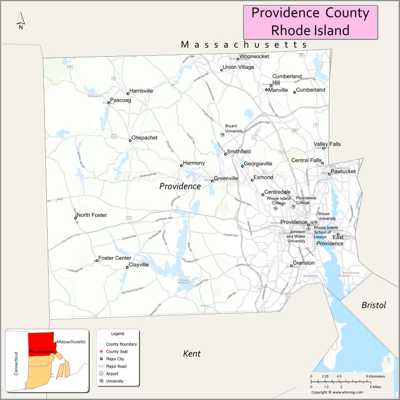
About Providence County Map, Rhode Island: The map showing the county boundary, county seat, major cities, highways, water bodies and neighbouring counties.
More Rhode Island Maps & Info
About Providence County, Rhode Island
Providence County is a county located in the U.S. state of Rhode Island. It's county seat is Providence. As per 2020 census, the population of Providence County is 658221 people and population density is square miles. According to the United States Census Bureau, the county has a total area of 409 sq mi (1,059 km2). Providence County was established on 1703.
Providence County Facts
| Continent | North America |
| Country | United States |
| State | Rhode Island |
| County Seat | Providence |
| Largest City/Town | Providence |
| Established | 1703 |
| Total Area | 436.8 sq mi (1,131.3 sq km) |
| Land Area | 410.1 sq mi (1,062.2 sq km) |
| Water Area | 26.7 sq mi (69.1 sq km) |
| Population | 660,741 (Census 2020) |
| Population Density | 1,611.1 people per sq mi |
| Time Zone | Eastern Time Zone |
| Major Highways | Interstate 95, Interstate 195, Interstate 295, US Route 6, US Route 44, Rhode Island Route 146 |
| Major Rivers | Providence River, Blackstone River, Woonasquatucket River, Pawtuxet River, Moshassuck River |
| Neighboring Counties | Bristol County (Rhode Island), Kent County (Rhode Island), Washington County (Rhode Island), Bristol County (Massachusetts), Worcester County (Massachusetts), Norfolk County (Massachusetts) |
| Famous For | Providence, Brown University, Rhode Island School of Design, WaterFire, and Blackstone Valley history |
| Top Attractions | WaterFire, Roger Williams Park, Rhode Island State House, RISD Museum, and Blackstone River Valley |
| Official Website | Official Website |
About Providence County, Rhode Island
Providence County is located in northern Rhode Island and was established in 1703. The county seat and largest city is Providence, the state capital. As the most populous county in Rhode Island, it serves as the state's economic, educational, cultural, and governmental center. The county includes urban centers, historic mill towns, suburban communities, and scenic river valleys.
Cities and Towns in Providence County, Rhode Island
| City/Town | Population (Census 2020) | Latitude & Longitude |
|---|---|---|
| Providence (county seat) | 190,934 | 41.8240°N, 71.4128°W |
| Pawtucket | 75,604 | 41.8787°N, 71.3826°W |
| Central Falls | 22,583 | 41.8907°N, 71.3923°W |
| Cranston | 82,934 | 41.7798°N, 71.4373°W |
| East Providence | 47,139 | 41.8137°N, 71.3701°W |
| Johnston | 29,568 | 41.8265°N, 71.5184°W |
| Lincoln | 22,529 | 41.9218°N, 71.4359°W |
| North Providence | 33,523 | 41.8501°N, 71.4662°W |
| North Smithfield | 12,441 | 41.9668°N, 71.5495°W |
| Smithfield | 22,118 | 41.9220°N, 71.5498°W |
| Woonsocket | 43,240 | 42.0029°N, 71.5148°W |
| Burrillville | 16,158 | 41.9559°N, 71.7023°W |
| Cumberland | 36,405 | 41.9665°N, 71.4323°W |
| Glocester | 10,389 | 41.8729°N, 71.6681°W |
| Foster | 4,350 | 41.7815°N, 71.7181°W |
| Scituate | 10,384 | 41.8320°N, 71.5878°W |
Best Golf Courses in Providence County, Rhode Island
| Golf Course | Location | Latitude & Longitude |
|---|---|---|
| Triggs Memorial Golf Course | Providence | 41.8195°N, 71.4650°W |
| Wannamoisett Country Club | East Providence | 41.8194°N, 71.3476°W |
| Metacomet Country Club | East Providence | 41.8454°N, 71.3588°W |
| Kirkbrae Country Club | Lincoln | 41.9357°N, 71.4648°W |
| Louisquisset Golf Club | North Providence | 41.8715°N, 71.4707°W |
| Crystal Lake Golf Club | Burrillville | 41.9693°N, 71.6849°W |
| Country View Golf Club | Harrisville | 41.9830°N, 71.6732°W |
| Glocester Country Club | Chepachet | 41.9167°N, 71.7021°W |
| Laurel Lane Country Club | West Kingston/Smithfield Area | 41.9092°N, 71.5607°W |
What are Major Roads and Highways in Providence County
Major highways connect the county to nearby regions and cities.
- Interstate 95 - primary north-south interstate through Providence connecting Boston and New York City
- Interstate 195 - connects Providence with East Providence and southeastern Massachusetts
- Interstate 295 - western bypass serving suburban communities
- US Route 6 - major east-west corridor through Providence and Johnston
- US Route 44 - connects Providence with Smithfield and western Rhode Island
- Rhode Island Route 146 - expressway connecting Providence with Worcester, Massachusetts
Neighboring Counties of Providence County
- Bristol County, Rhode Island (southeast)
- Kent County, Rhode Island (south)
- Washington County, Rhode Island (southwest)
- Bristol County, Massachusetts (east)
- Norfolk County, Massachusetts (northeast)
- Worcester County, Massachusetts (northwest)
What are Top Attractions in Providence County, Rhode Island
The county offers a mix of natural and cultural attractions.
| Main Sight Name | City | Famous For |
|---|---|---|
| WaterFire | Providence | Iconic riverfront art installation and cultural event |
| Roger Williams Park | Providence | Large urban park with gardens, zoo, and recreation |
| Roger Williams Park Zoo | Providence | One of the oldest zoos in the United States |
| Rhode Island State House | Providence | Historic state capitol building |
| RISD Museum | Providence | Internationally recognized art museum |
| Brown University | Providence | Ivy League university founded in 1764 |
| Providence Performing Arts Center | Providence | Broadway shows and live performances |
| Blackstone River Valley National Historical Park | Pawtucket | Birthplace of America's Industrial Revolution |
| Slater Mill Historic Site | Pawtucket | America's first successful water-powered textile mill |
| Lincoln Woods State Park | Lincoln | Hiking, swimming, and outdoor recreation |
| Scituate Reservoir | Scituate | Largest inland body of water in Rhode Island |
| Mowry Conservation Area | Smithfield | Nature trails and wildlife viewing |
| Woonsocket Museum of Work and Culture | Woonsocket | French-Canadian heritage and labor history |
| Snake Den State Park | Johnston | Historic farmland and walking trails |
| Pawtuxet Village Historic District | Cranston | Historic waterfront district and colonial architecture |
Distance from Providence County to Nearby Cities
The following distances are measured by road (driving).
- Providence to Cranston (Providence County), Rhode Island - 5 mi (8 km)
- Providence to Pawtucket (Providence County), Rhode Island - 5 mi (8 km)
- Providence to East Providence (Providence County), Rhode Island - 4 mi (6 km)
- Providence to Woonsocket (Providence County), Rhode Island - 17 mi (27 km)
- Providence to Warwick (Kent County), Rhode Island - 11 mi (18 km)
- Providence to Bristol (Bristol County), Rhode Island - 16 mi (26 km)
- Providence to Newport (Newport County), Rhode Island - 34 mi (55 km)
- Providence to Narragansett (Washington County), Rhode Island - 32 mi (51 km)
- Providence to Fall River (Bristol County), Massachusetts - 20 mi (32 km)
- Providence to New Bedford (Bristol County), Massachusetts - 35 mi (56 km)
- Providence to Attleboro (Bristol County), Massachusetts - 12 mi (19 km)
- Providence to Worcester (Worcester County), Massachusetts - 44 mi (71 km)
- Providence to Boston (Suffolk County), Massachusetts - 50 mi (80 km)
- Providence to Hartford (Hartford County), Connecticut - 72 mi (116 km)
- Providence to New Haven (New Haven County), Connecticut - 108 mi (174 km)
References
- QuickFacts - Providence County, Rhode Island
- United States Census Bureau
- United States Geological Survey (USGS)
- National Geodetic Survey
- Official Providence Website
- Alabama Counties
- Alaska boroughs
- Arizona Counties
- Arkansas Counties
- California County Map
- Colorado Counties
- Connecticut Counties
- Delaware Counties
- Florida County Map
- Georgia County Map
- Hawaii Counties
- Idaho Counties
- Illinois Counties
- Indiana Counties
- Iowa Counties
- Kansas Counties
- Kentucky Counties
- Louisiana Counties
- Maine Counties
- Maryland Counties
- Massachusetts Counties
- Michigan County Map
- Minnesota Counties
- Mississippi Counties
- Missouri Counties
- Montana Counties
- Nebraska Counties
- Nevada Counties
- New York Counties
- New Hampshire Counties
- New Jersey Counties
- New Mexico Counties
- North Carolina Counties
- North Dakota Counties
- Ohio County Map
- Oklahoma Counties
- Oregon Counties
- Pennsylvania Counties
- Rhode Island Counties
- South Carolina Counties
- South Dakota Counties
- Map of Tennessee
- Texas County Map
- Utah Counties
- Vermont Counties
- Virginia Counties
- Washington Counties
- West Virginia Counties
- Wisconsin Counties
- Wyoming Counties