
Where is Bennington Located? - Bennington is a city located in the Bennington County of Vermont, United States. Bennington lies between 42.88266 Degrees North latitudes and -73.1923 Degrees West longitudes.
Location Map of Bennington, Vermont
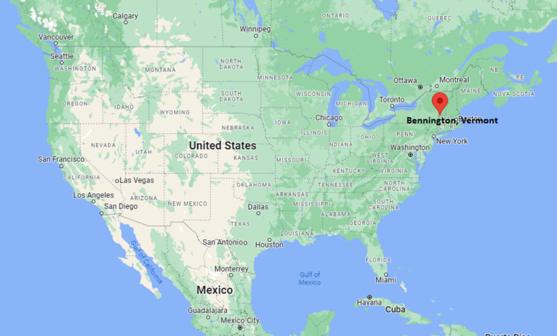
Bennington Map, Vermont, USA
Where is Bennington?: The Google Map showing the location of Bennington in the U.S. state of Vermont.
Where is Bennington Located?
Bennington is a town located in the Bennington County of Vermont, United States. Bennington lies at approximately 42.88266 Degrees North latitude and -73.1923 Degrees West longitude. According to the 2020 U.S. Census, the population of Bennington town is 8,795 people and the town has a total area of 4.867 sq mi. The town has numerous parks and recreational facilities.
Most Viewed US Maps
| USA Sttae Map | USA Region Map | USA Road Map |
| USA County Map | Where is USA in World Map? | US ZIP Code Map |
| USA Time Zones Map | US State and Capitals Map | USA Physical Map |
Find 4,400+ U.S. Cities by State - Explore Their Locations and Get Detailed Information
Bennington, Vermont Quick Facts
| Fact | Details |
|---|---|
| Town | Bennington |
| County | Bennington County |
| State | Vermont |
| State Capital | Montpelier |
| Country | United States |
| US Region | Northeast |
| Latitude | 42.88266 N |
| Longitude | -73.1923 W |
| Elevation | 545 ft (166 m) |
| Land Area | 42.5 sq mi |
| Water Area | 0.3 sq mi |
| Total Area | 4.867 sq mi |
| Population (Census 2020) | 15,333 |
| Population Density | Approximately 361 per sq mi |
| ZIP Code | 05201 |
| Area Code | 802 |
| Time Zone Standard | Eastern Standard Time (EST, UTC-5) |
| Time Zone Daylight | Eastern Daylight Time (EDT, UTC-4) |
| Currency | United States Dollar (USD) |
| FIPS Code | 50-04825 |
| Congressional District | Vermont At-Large Congressional District |
Nearby Cities and Towns to Bennington, Vermont
- North Bennington, Vermont - 3 mi Northwest
- Williamstown, Massachusetts - 14 mi South
- Hoosick Falls, New York - 14 mi West
- Arlington, Vermont - 17 mi North
- Manchester, Vermont - 22 mi Northeast
- Pownal, Vermont - 13 mi Southwest
- Cambridge, New York - 24 mi West
- Pittsfield, Massachusetts - 35 mi Southeast
- Troy, New York - 38 mi West
- Albany, New York - 41 mi Southwest
Bennington, Vermont Climate and Weather Overview
| Month | Avg High (°F) | Avg Low (°F) | Avg Rainfall (in) |
|---|---|---|---|
| January | 29 | 12 | 2.9 |
| April | 57 | 35 | 3.7 |
| July | 81 | 59 | 4.4 |
| October | 60 | 39 | 3.9 |
| Annual | 57 | 37 | 45.5 |
| Climate Attribute | Details |
|---|---|
| Climate Classification | Humid Continental (Köppen Dfb) |
| Annual Rainfall | Approximately 46 inches |
| Annual Sunshine Days | About 187 days |
| Hurricane/Tornado Risk | Low - Winter storms, heavy snow and occasional flooding |
| Snowfall | Approximately 63 inches annually |
Driving Distances from Bennington, Vermont
| City | State | Distance (mi) | Approx. Drive Time |
|---|---|---|---|
| North Bennington | Vermont | 3 | 6 min |
| Pownal | Vermont | 13 | 18 min |
| Williamstown | Massachusetts | 14 | 20 min |
| Hoosick Falls | New York | 14 | 20 min |
| Arlington | Vermont | 17 | 22 min |
| Manchester | Vermont | 22 | 30 min |
| Cambridge | New York | 24 | 35 min |
| Pittsfield | Massachusetts | 35 | 45 min |
| Troy | New York | 38 | 50 min |
| Albany | New York | 41 | 55 min |
Transportation and Connectivity in Bennington, Vermont
| Transportation | Details |
|---|---|
| Airport Name | William H. Morse State Airport |
| IATA Code | DDH |
| Port | Not Applicable |
| Major Highways | U.S. Highway 7, Vermont Route 9, Vermont Route 67A, Vermont Route 279 |
| Train/Amtrak Service | Nearest Amtrak station at Albany-Rensselaer, New York |
| Local Bus/Transit Service | Green Mountain Community Network (The Bus) |
- U.S. Highway 7 - Primary north-south highway connecting Bennington with Burlington, Rutland and western Massachusetts.
- Vermont Route 9 - Major east-west highway linking Bennington with Brattleboro and New York State.
- Vermont Route 67A - Connects downtown Bennington with North Bennington and nearby commercial areas.
- Vermont Route 279 - Limited-access bypass providing quick access to New York and reducing through traffic in the town center.
Key Landmarks and Places to Visit in Bennington, Vermont
| Landmark | Type |
|---|---|
| Bennington Battle Monument | Historic Monument |
| Bennington Museum | Museum |
| Old First Church | Historic Church |
| Robert Frost Stone House Museum | Historic House Museum |
| Downtown Bennington Historic District | Historic District |
| Lake Paran | Recreation Area |
| Silk Road Covered Bridge | Historic Covered Bridge |
| Harmon Hill Trail | Hiking Trail |
| Bennington Center for the Arts | Arts Center |
| Woodford State Park | State Park |
Colleges and Universities in Bennington, Vermont
| Institution | Type | Level | Notable For |
|---|---|---|---|
| Bennington College | Private | College | Liberal arts, visual arts and creative writing |
| Southern Vermont College (former campus) | Private | Former College | Historic higher education campus |
| Community College of Vermont - Bennington | Public | Community College | Associate degrees and workforce education |
| Williams College | Private | College | Liberal arts and research |
| Massachusetts College of Liberal Arts | Public | College | Liberal arts and education |
| Vermont State University | Public | University | Professional and undergraduate programs |
Waterbodies in Bennington, Vermont
Walloomsac River, Paran Creek, Lake Paran, Roaring Branch, Green River, Hemlock Brook, Furnace Brook, Woodford Reservoir, Batten Kill, Hudson River (nearby watershed).
Golf Courses in Bennington, Vermont
Mount Anthony Country Club, Prospect Mountain Country Club, Waubeeka Golf Links, Equinox Golf Resort, Dorset Field Club, Windham Country Club, Haystack Golf Club, Saratoga National Golf Club.
Bennington, Vermont - Key Historical Facts
- Bennington was chartered in 1749, making it the first town established in what is now the state of Vermont.
- The town is best known for the 1777 Battle of Bennington, a key American victory during the Revolutionary War that helped pave the way for success at Saratoga.
- The Bennington Battle Monument, completed in 1891, commemorates this important Revolutionary War event and is the tallest human-made structure in Vermont.
- Throughout the nineteenth century, Bennington developed as a regional center for manufacturing, pottery, textiles and commerce.
- The town has a rich literary and artistic heritage, with notable connections to poet Robert Frost and the progressive educational traditions of Bennington College.
- Today, Bennington is recognized for its historic downtown, cultural attractions, outdoor recreation and scenic location near the Green Mountains.
References
Vermont Maps and Info
- Where is Barre
- Where is Bellows Falls
- Where is Bennington
- Where is Bradford
- Where is Brandon
- Where is Brattleboro
- Where is Bristol
- Where is Burlington
- Where is Castleton
- Where is Chester
- Where is Enosburg Falls
- Where is Essex Junction
- Where is Fair Haven
- Where is Hardwick
- Where is Jericho
- Where is Johnson
- Where is Lyndonville
- Where is Manchester Center
- Where is Middlebury
- Where is Milton
- Where is Montpelier
- Where is Morrisville
- Where is Newport
- Where is North Bennington
- Where is Norwich
- Where is Pittsford
- Where is Poultney
- Where is Quechee
- Where is Randolph
- Where is Richford
- Where is Rutland
- Where is Shelburne
- Where is South Barre
- Where is South Burlington
- Where is St. Albans
- Where is St. Johnsbury
- Where is Swanton
- Where is Vergennes
- Where is Wallingford
- Where is West Brattleboro
- Where is West Rutland
- Where is White River Junction
- Where is Wilder
- Where is Williamstown
- Where is Windsor
- Where is Winooski
- Where is Woodstock