
Where is Brandon Located? - Brandon is a city located in the Rutland County of Vermont, United States. Brandon lies between 43.80647 Degrees North latitudes and -73.0882 Degrees West longitudes.
Location Map of Brandon, Vermont
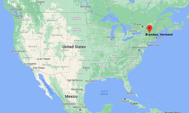
Brandon Map, Vermont, USA
Where is Brandon?: The Google Map showing the location of Brandon in the U.S. state of Vermont.
Where is Brandon Located?
Brandon is a town located in the Rutland County of Vermont, United States. Brandon lies between 43.80647 Degrees North latitude and -73.0882 Degrees West longitude. According to the 2020 U.S. Census, the population of Brandon town is 3,966 people and the town has a total area of 2.835 sq mi. The town has numerous parks and recreational facilities.
Most Viewed US Maps
| USA Sttae Map | USA Region Map | USA Road Map |
| USA County Map | Where is USA in World Map? | US ZIP Code Map |
| USA Time Zones Map | US State and Capitals Map | USA Physical Map |
Find 4,400+ U.S. Cities by State - Explore Their Locations and Get Detailed Information
Brandon, Vermont Quick Facts
| Fact | Details |
|---|---|
| Town | Brandon |
| County | Rutland County |
| State | Vermont |
| State Capital | Montpelier |
| Country | United States |
| US Region | Northeast |
| Latitude | 43.80647 N |
| Longitude | -73.0882 W |
| Elevation | 463 ft (141 m) |
| Land Area | 39.42 sq mi |
| Water Area | 0.53 sq mi |
| Total Area | 2.835 sq mi |
| Population (Census 2020) | 3,966 |
| Population Density | Approximately 101 per sq mi |
| ZIP Code | 05733 |
| Area Code | 802 |
| Time Zone Standard | Eastern Standard Time (EST, UTC-5) |
| Time Zone Daylight | Eastern Daylight Time (EDT, UTC-4) |
| Currency | United States Dollar (USD) |
| FIPS Code | 50-08125 |
| Congressional District | Vermont At-Large Congressional District |
Nearby Cities and Towns to Brandon, Vermont
- Pittsford, Vermont - 12 mi South
- Middlebury, Vermont - 16 mi North
- Leicester, Vermont - 6 mi South
- Salisbury, Vermont - 10 mi North
- Rutland, Vermont - 22 mi South
- Vergennes, Vermont - 29 mi North
- Fair Haven, Vermont - 33 mi Southwest
- Ticonderoga, New York - 29 mi West
- Bristol, Vermont - 28 mi Northeast
- Burlington, Vermont - 57 mi North
Brandon, Vermont Climate and Weather Overview
| Month | Avg High (°F) | Avg Low (°F) | Avg Precipitation (in) |
|---|---|---|---|
| January | 28 | 10 | 2.7 |
| April | 56 | 34 | 3.2 |
| July | 81 | 59 | 4.1 |
| October | 59 | 39 | 3.5 |
| Annual | 56 | 36 | 42.3 |
| Climate Attribute | Details |
|---|---|
| Climate Classification | Warm-Summer Humid Continental (Köppen Dfb) |
| Annual Precipitation | Approximately 42.3 inches |
| Annual Sunshine Days | About 182 days |
| Severe Weather Risk | Moderate - Winter snowstorms, spring flooding and occasional summer thunderstorms |
| Annual Snowfall | Approximately 75 inches |
Driving Distances from Brandon, Vermont
| Town/City | State | Distance (mi) | Approx. Drive Time |
|---|---|---|---|
| Leicester | Vermont | 6 | 10 min |
| Salisbury | Vermont | 10 | 15 min |
| Pittsford | Vermont | 12 | 18 min |
| Middlebury | Vermont | 16 | 22 min |
| Rutland | Vermont | 22 | 30 min |
| Bristol | Vermont | 28 | 40 min |
| Ticonderoga | New York | 29 | 40 min |
| Vergennes | Vermont | 29 | 40 min |
| Fair Haven | Vermont | 33 | 45 min |
| Burlington | Vermont | 57 | 1 hr 10 min |
Transportation and Connectivity in Brandon, Vermont
| Transportation | Details |
|---|---|
| Nearest Airport | Rutland–Southern Vermont Regional Airport |
| IATA Code | RUT |
| Nearest Major Airport | Burlington International Airport |
| Major Highways | U.S. Route 7, Vermont Route 73 |
| Rail Service | Amtrak Ethan Allen Express available at nearby Rutland |
| Local Transit | The Bus (Marble Valley Regional Transit District) |
- U.S. Route 7 is the primary north-south highway connecting Brandon with Rutland, Middlebury and Burlington.
- Vermont Route 73 provides access to the Green Mountains, Lake Champlain Valley and nearby recreation areas.
- Rutland–Southern Vermont Regional Airport, about 22 miles south, serves general aviation, while Burlington International Airport offers commercial flights.
- Marble Valley Regional Transit (The Bus) provides regional public transportation linking Brandon with neighboring Vermont communities.
Key Landmarks and Places to Visit in Brandon, Vermont
| Landmark | Type |
|---|---|
| Brandon Village Historic District | Historic District |
| Brandon Museum | Local History Museum |
| Neshobe River | Scenic River |
| Brandon Town Hall and Opera House | Historic Performing Arts Venue |
| Brandon Artists Guild | Art Gallery |
| Fern Lake | Recreation Area |
| Moosalamoo National Recreation Area | National Recreation Area |
| Branbury State Park | State Park |
| Lake Dunmore | Freshwater Lake |
| Mount Horrid Trail | Hiking Destination |
Colleges and Universities in Brandon, Vermont
| Institution | Type | Level | Notable For |
|---|---|---|---|
| Middlebury College | Private | Liberal Arts College | Liberal arts, languages and international studies |
| Castleton University (Vermont State University) | Public | University | Education, business and health sciences |
| Community College of Vermont - Rutland Center | Public | Community College | Associate degrees and workforce training |
| Vermont State University - Randolph Center | Public | University | Technical education and applied sciences |
| Norwich University | Private | University | Military education, engineering and cybersecurity |
| University of Vermont | Public | Research University | Medicine, agriculture and environmental sciences |
Waterbodies in Brandon, Vermont
Neshobe River, Lake Dunmore, Fern Lake, Burr Pond, Otter Creek, Silver Lake, Leicester River, Chittenden Reservoir, Lake Hortonia, Sunset Lake.
Golf Courses in Brandon, Vermont
Neshobe Golf Club, Proctor-Pittsford Country Club, Rutland Country Club, Middlebury College Golf Course, Green Mountain National Golf Course, Lake St. Catherine Country Club, Ralph Myhre Golf Course, Killington Golf Course.
Brandon, Vermont - Key Historical Facts
- Brandon was chartered in 1761 by Governor Benning Wentworth of New Hampshire and became one of Vermont's earliest settled communities after the American Revolution.
- The town grew into an important industrial center during the nineteenth century, with mills powered by the Neshobe River producing iron goods, textiles and marble products.
- Its well-preserved downtown features many historic brick buildings that reflect Brandon's prosperity during the Victorian era.
- Brandon became known as an arts community during the twentieth century, attracting artists, craftspeople and galleries to its historic village center.
- Tourism has expanded because of the town's proximity to the Green Mountains, Lake Dunmore and nearby outdoor recreation areas.
- Today, Brandon is recognized for its historic architecture, vibrant arts scene, locally owned businesses and access to hiking, fishing and year-round recreation.
References
- Town of Brandon
- U.S. Census Bureau
- Vermont Tourism
- Vermont Agency of Commerce and Community Development
Vermont Maps and Info
- Where is Barre
- Where is Bellows Falls
- Where is Bennington
- Where is Bradford
- Where is Brandon
- Where is Brattleboro
- Where is Bristol
- Where is Burlington
- Where is Castleton
- Where is Chester
- Where is Enosburg Falls
- Where is Essex Junction
- Where is Fair Haven
- Where is Hardwick
- Where is Jericho
- Where is Johnson
- Where is Lyndonville
- Where is Manchester Center
- Where is Middlebury
- Where is Milton
- Where is Montpelier
- Where is Morrisville
- Where is Newport
- Where is North Bennington
- Where is Norwich
- Where is Pittsford
- Where is Poultney
- Where is Quechee
- Where is Randolph
- Where is Richford
- Where is Rutland
- Where is Shelburne
- Where is South Barre
- Where is South Burlington
- Where is St. Albans
- Where is St. Johnsbury
- Where is Swanton
- Where is Vergennes
- Where is Wallingford
- Where is West Brattleboro
- Where is West Rutland
- Where is White River Junction
- Where is Wilder
- Where is Williamstown
- Where is Windsor
- Where is Winooski
- Where is Woodstock